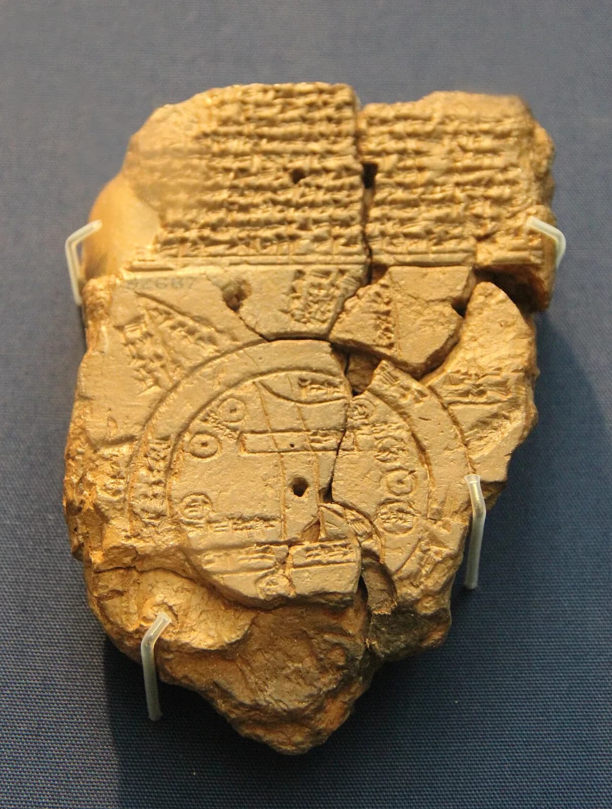
A clay tablet in the British Museum measures 12.2 by 8.2 centimeters. The top half holds a drawing of two circles with a river running through them. Past the outer circle are triangles, and beside them the scribe wrote how far away each one is.
On the back the scribe wrote that no one knows what is inside them.
The traditional view
The British Museum dates the surviving tablet to about the sixth century BC. Hormuzd Rassam excavated it at Abu Habba, ancient Sippar. The museum describes a map that shows the world as a disc, "surrounded by a ring of water called the 'Bitter River.'" Babylon is marked as a rectangle at the right end of the Euphrates.
Other places carry names. The museum lists Assyria, Der, Bit-Yakin, Habban and Urartu. It says Habban is "placed quite wrongly to the west of Babylon," while Urartu is placed "relatively correctly to the north of Assyria."
The museum's curator adds that a note at the end of the tablet says it was copied from an earlier document. The place names show that the original was composed "no earlier than the 9th century BC." Britannica calls it the oldest known map of the ancient world.
Wayne Horowitz published a new edition of the text in 1988. He calls the drawing "unique among ancient Mesopotamian maps." He writes that other cuneiform maps are drawn to scale, while on this one the size and location of many features "seem preposterous." His example is the circle for Der, which is as large as the circle for Assyria.
Alan Millard notes that Babylonian scribes drew older maps. A clay map from Yorghan Tepe dates to about 2300 B.C. and a plan of Nippur to about 1500 B.C. The claim of age therefore holds for this tablet as a map of the whole world.
Two Newer Readings
Paul Delnero of Johns Hopkins University wrote a paper on the map in 2018. In the abstract he says scholars have "almost without exception" read it as an "idealized and highly ideological picture of the cosmos." In that reading Babylon occupies "its privileged center." He proposes to examine the map "as a dynamic, as opposed to static image." I have read only the abstract.
Irving Finkel is a curator at the British Museum. In a museum video, the Armstrong Institute of Biblical Archaeology prints his reading of the fourth region on the back of the tablet. The line says something is "as thick as a parsiktu-vessel." Finkel says the word is "only once otherwise known from cuneiform tablets," in the description of the ark built by the Babylonian Noah.
He says that a climber would see "the wreck of the Babylonian ark" against the dark sky. I have not watched the video myself.
Horowitz translates the same line as "thick as a parsiktum-measure/vessel, 20 finger(s)" and does not link it to an ark. The Armstrong article prints "10 fingers." I have not checked the signs. Horowitz says that only the descriptions of the third, fifth, seventh and eighth regions are "even partially intelligible." He adds that "it is not possible to correlate the surviving nagû on the map with those described on the reverse."
The fragment that Finkel identified was joined to the tablet in the 1990s. I do not know whether Horowitz revised that sentence afterward.
The tablet names Utnapishtim, the hero of the Gilgamesh flood, on its front. In Earthly Enigmas I follow the Gilgamesh flood account under the heading "What Gilgamesh Actually Says." I write there that it "reads less like vague myth and more like a compressed historical account." The museum notes that the word for the outer regions, nagu, also appears in Gilgamesh when the flood recedes.
What the Tablet Cannot Say
Both readings lean on questions the evidence cannot yet answer. Three of them stand out.
Is it a map or a diagram?
The museum calls the tablet a map of the world. Millard writes that it is "not so much a topographical map as an attempt to illustrate ideas expressed in the accompanying text." He calls it "really a diagram." Horowitz says the writing suggests that the purpose was "to locate and describe distant regions."
The drawing gets some things right. Horowitz calls the course of the Euphrates relatively accurate, and Urartu sits north of Assyria. The drawing also omits the Tigris. Horowitz says the ocean ring is not much wider than the Euphrates and puts that down to "the crudity of the map."
The center of the drawing is read two ways. Horowitz says the central point is an unlabeled compass point with Babylon above it, so Babylon "cannot be considered the umbilicus of the Babylonian world." The museum calls the hole at the center a "firing hole" that the scribe made on purpose.
What was the drawing made to do?
What lies beyond the Bitter River?
The museum says the triangles may have been imagined as mountains. Horowitz writes that they may be islands. He adds that they may be "a distant land mass" or may extend over the far edge of the earth. Britannica says some scholars read them as mythological regions and others as real areas beyond the known world.
The writing on the tablet names what is there. A caption beside the northeastern region reads "Where Shamash is not seen." The front lists beasts that Marduk made and three heroes, Utnapishtim, Sargon and Nur-Dagan. On the back one region is a place where "a winged [bi]rd cannot safely comp[lete its journey]."
The scribe gives each region a distance of six or seven bēru. Millard puts a bēru at about ten kilometers, so seven bēru comes to roughly 70 kilometers by my arithmetic. Horowitz suggests the figure may be the crossing of the ocean to each region. The text ends by saying that no one knows the interior.
Where did the Babylonians think the triangles were, and what did they think was inside them?
How much of the tablet do we have?
The sources give different dates. The museum says the tablet is from about the sixth century BC and copies an older text. Horowitz thinks the original dates to the late eighth or seventh century. Millard gives about 600 B.C. Britannica gives a range from the late eighth to the sixth century.
The tablet is broken. Britannica says five triangles survive and that the back of the tablet suggests there were eight. Horowitz writes that a third one "has now fallen off" since an early photograph. Britannica says a piece broke off during a loan and that a fragment was reattached in 1995.
The museum also says it is "not clear why" the map gives the distance as six bēru twice while the text gives seven. Horowitz says the findspot is "uncertain" and the tablet may come from Borsippa. Britannica says it is unclear whether the copy note covers the whole tablet or only the back.
How much of what we read belongs to the original, how much to the copyist and how much to the breaks?
The questions I can't put down
Some questions need more room than one article gives them. Two of them keep pulling me back.
Where are the other maps? Herodotus writes in the Godley translation, "I laugh to see how many have before now drawn maps of the world, not one of them reasonably." He describes them as round and encircled by the Ocean river. Horowitz notes that none of those Greek maps survives. Millard says mapmaking "cannot have been common among the scribes of ancient Babylonia." Horowitz says only this one is drawn "on an international scale." In the book I follow that thread under the heading "Knowledge of the Entire Globe." The Piri Reis Map article asks the same question about a later chart. I follow it through Earthly Enigmas.
What did the mapmaker know? Horowitz says the author "was well versed in geometry," and he points to Old Babylonian tablets with circles inside circles. Millard writes that the Pythagorean theorem "was understood both in practice and in theory in the seventeenth century B.C., a millennium before Pythagoras himself was born." I have not checked that claim. In the book I write that Pythagoras went to Babylon and was "a transmitter, not an originator." I have not checked the Babylon claim either. You can read a free sample of the book before you decide. The articles section has more subjects in the same format.
Sources
- British Museum collection record: The Map of the World, tablet 92687
- Wayne Horowitz, Mesopotamian Cosmic Geography (Eisenbrauns, 1998), Chapter 2, "The Babylonian Map of the World" (read as a third-party scan; the print edition should be checked)
- Alan Millard, Cartography in the Ancient Near East, History of Cartography, vol. 1, ch. 6 (University of Chicago Press, 1987)
- Britannica: Babylonian Map of the World (secondary)
- Paul Delnero, A Land with No Borders, JANEH 4/1 (2018) (abstract only, via Academia)
- Armstrong Institute of Biblical Archaeology: The Imago Mundi, Babylonian Directions to Noah's Ark (2024) (secondary, for Irving Finkel's words from the British Museum video)
- Herodotus, Histories 4.36, Godley translation (Perseus)