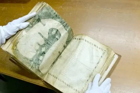
The map fits on one sheet of parchment. UNESCO's nomination form gives its size as 27 by 22.5 centimeters. East is at the top and the Mediterranean runs down the middle in dark green.
Small circles run along almost every coast. The form calls this figuration very unusual. It asks whether the circles stand for rocks and does not settle the question.
The same sheet raises a larger one. Where did the picture come from?
The traditional view
The map sits in manuscript 29 at the Pierre-Amalric library in Albi, in southern France. UNESCO's form describes a manuscript of 77 sheets and 156 pages that forms a collection of 22 texts. The map is on sheet 57 and an Index of winds and seas follows it on sheet 58.
UNESCO added the map to its Memory of the World Register in 2015. The form calls it "one of the first two non-symbolic and non-abstract world maps." The City of Albi keeps the manuscript. It says access to the original is reserved for researchers and that a facsimile is shown in the treasury of Sainte-Cécile cathedral.
The form says the map "does not bear an explicit fabrication date" and that specialists propose the second half of the 8th century. It places the work in Gaul, probably in Albi, or in Septimania or even in Spain. A materials study in the Journal of Cultural Heritage in 2025 gives a similar range. Its abstract says the map was "probably made in the second half of the 8th century." It places the work "somewhere between south-western France and northern Spain, maybe in Albi itself." I have read only the abstract.
The form describes the inhabited world as "oblong-shaped, a sort of horseshoe with the opening representing the Gibraltar strait." It counts 25 countries or regions and 51 names, all written in uncial script. Jerusalem is marked, but unlike on other Christian world maps it does not sit at the center.
Alfred Hiatt, writing in a 2022 volume on the map, is plain about how little it shows. He describes "schematic representation of coastlines, relatively few cities, and just six islands."
The editors of that volume, Emmanuelle Vagnon and Sandrine Victor, say the map was once read as proof of cultural decline next to Ptolemy's geography. They write that historians now see it as evidence of common mapmaking practice, perhaps in school settings (my translation). Their introduction is the best single survey I found of what is and is not agreed.
A Map Drawn From Older Maps
UNESCO's form says the map was "likely taken from an antique map that was updated and Christianized." The form says that of all the surviving mappae mundi Albi's is the closest, in form and content, to an older model. It describes that model as one "that would have existed in late Antiquity, which has not survived but which, thanks to studies, we can suppose the existence of."
Hiatt writes that the Albi, Cotton and Vatican maps "all three ultimately derive from earlier models." The Vagnon and Victor introduction describes the Albi map as a survivor of a production that was perhaps abundant and often made on perishable supports (my translation).
In Earthly Enigmas I follow another map built from older maps. I write that someone before 1513 had mapped the Atlantic coastlines with unusual accuracy. The source maps behind the Piri Reis chart have not been found. The Piri Reis article sets out that case. In Chapter 11 I list the burning of the Library of Alexandria among the losses.
What Has Not Been Settled
Both views lean on questions the evidence cannot yet answer. Three of them stand out.
How firm is the date?
The nomination form says the manuscript carries no date. It names one main clue. The form says the town of Ravenna is shown at the same size as Rome. It notes that Ravenna fell to the Lombards in 752 and to the Frankish king Pepin in 756. From this it proposes the second half of the 8th century.
The Vagnon and Victor introduction reports that the contributors agree on the last quarter of the 8th century. It also records an objection to the Ravenna clue. Ravenna had been a Gothic capital in the 5th century, and the Goths appear on the map. The city could therefore be much older than the event in 756 (my translation).
The same introduction says that the specialist Marc Smith finds the style of the uncial script a better fit for the early 9th century than the 8th. Nadège Corbière calls the Ravenna clue "possible but slight" in her chapter. She says the first half of the 8th century is unlikely because two of the texts were composed in that century (my translation).
The introduction adds that the map reflects the geography of late antiquity as the copyists passed it down. It does not show the territorial changes of the early Middle Ages. A date for the copy is therefore a separate matter from a date for the picture.
A monograph on the My Old Maps site titles the map "750 A.D." and describes it as the work of about 730. I treat that page as a secondary source.
What would a firm date for this map rest on?
What was it for?
UNESCO's form says the whole manuscript "clearly had a scholastic, pedagogical leaning" and that it "could have been a 'teacher's handbook'." It says the lower corners of the sheets are worn where fingers hold them, which it reads as proof of "long and regular use."
The form also reports Patrick Gautier Dalché's idea that the map served as an aid to meditation, since it shows the world as only God could see it. It adds "We have no written evidence of this practice." It says as well that medieval maps had an ideological aim, to show the need to spread Christianity to regions that remained pagan.
Corbière reads the manuscript differently. She sees a guide for monks, with grammar to understand the Bible and ascetic texts to support meditation (my translation).
The introduction says the exegetical and teaching role seems the most relevant to the map's long use. It also asks questions it does not answer. Do the box-like compartments show territorial limits, a divide between the civilized and the barbarian, or a history of peoples? Is the map's plainness a sign that it is unfinished or a deliberate simplification for teaching (my translation)?
The form itself says it is not certain the map was considered exceptional in the 8th century.
Who held this sheet in their hands, and what did they ask of it?
What was it copied from?
The scholars name several candidates and do not agree on any. Gautier Dalché has suggested that the horseshoe shape echoes a passage on the shape of the earth in the Periegesis of Dionysius, a Greek geographical poem. The introduction reports that Patrick Counillon, a specialist in Greek geography, thinks this unlikely because the map's place names have no link to the poem (my translation).
Anca Dan places the map in a tradition of regional mapping that goes back to Eratosthenes. She also argues that the Index of winds and seas on the facing sheet is a second, textual map from the same model. The introduction notes that Magali Coumert holds a different view on this point. It also says that Dan's link to the bishop Eucherius of Lyon needs further philological work and cannot yet be stated without qualification (my translation).
Hiatt writes that the Orosius text copied in the same manuscript seems to complement the map "rather than directly informing it." He says he remains "unconvinced that the Cotton map (or any of these maps) can with any great certainty be connected with specific ancient authors." He still finds it "highly likely that they retain certain formal elements that do descend from late antique originals."
The sources also differ on Isidore of Seville. UNESCO's form says the map "does not derive from a reading of Isidore of Seville either." The My Old Maps monograph, citing Evelyn Edson, says that 49 of the map's 50 place names appear in Book XIV of Isidore's Etymologiae. I have not checked that count.
What lies behind this map, and where is it now?
The questions I can't put down
Some questions need more room than one article gives them. Two of them keep pulling me back.
What happened at Jerusalem? A 2022 chapter by Laurianne Robinet and colleagues reports that imaging shows the area around Jerusalem was "possibly reworked, even scraped" (my translation). The chapter asks whether it was first painted green, like a river, and later covered in yellow, "but to what end?" UNESCO's form, prepared for the 2014 nomination, says "No additions have been made to the Mappa mundi. It is entirely original." The introduction to the 2022 volume attributes the changes at Jerusalem to the copyist (my translation). In the book I follow another old document that was miscataloged for centuries, the Chinon Parchment, and I ask what else sits in the archives. I follow that question through Earthly Enigmas.
How many maps like this were lost? UNESCO's form says the Albi map has no known equivalent and that no later copy was made. The Vagnon and Victor introduction reports Dan's conclusion that it was not exceptional in its day (my translation). It also reports that Gautier Dalché found a text in Naples describing an old world map. He links it to a map once kept at Bobbio. In the book I follow the maps behind the Piri Reis chart and the losses at Alexandria. You can read a free sample before you decide. The articles section has more subjects in the same format.
Sources
- UNESCO Memory of the World nomination form, The Mappa Mundi of Albi (English)
- City of Albi: La Mappa Mundi
- Robinet and colleagues, The Mappa mundi of Albi, Journal of Cultural Heritage 74 (2025) (abstract only)
- Vagnon and Victor (eds.), La Mappa mundi d'Albi (Éditions de la Sorbonne, 2022): introduction
- Robinet, Heu-Thao and Tournié, Analyse matérielle du manuscrit (same volume)
- Corbière, Le ms. 29 d'Albi: une encyclopédie du VIIIe siècle ? (same volume)
- Hiatt, The Cotton Mappa mundi as analogue to the Albi world map (same volume)
- My Old Maps: The Albi or Merovingian Map, #206 (secondary)