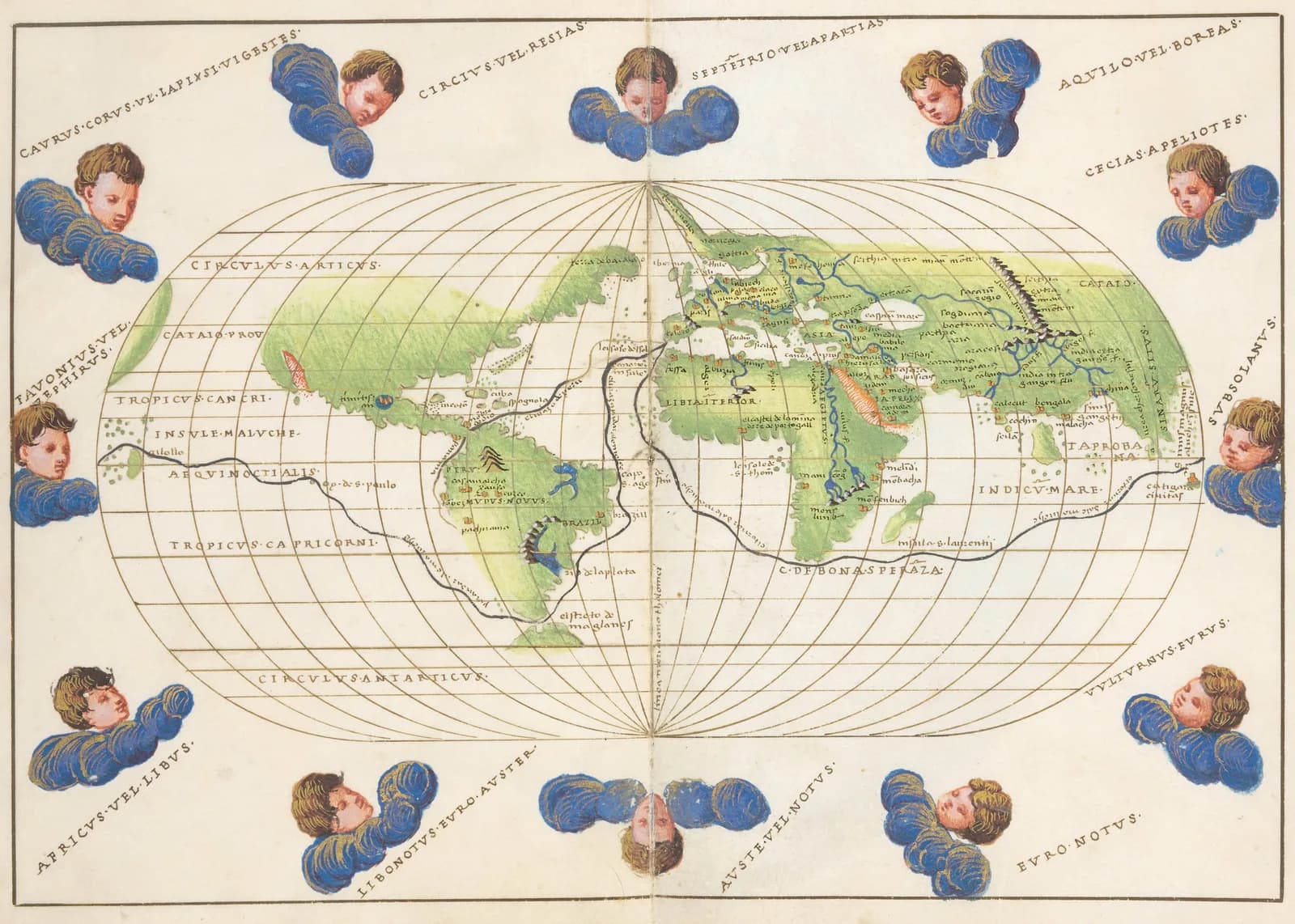
The Spanish national library holds a small atlas dated 1544. It measures 20 by 14 centimeters and has 16 parchment leaves with maps painted in bright colors and gold.
One leaf is a map of the whole world in an oval frame. Twelve painted wind heads blow around its edge.
The man who made it was Battista Agnese. More than 70 atlases from his workshop survive. The records about Agnese himself are thin.
The traditional view
The Biblioteca Nacional de España catalogs the atlas as a manuscript with the shelf mark RES/176. It describes maps of the Mediterranean, the Black Sea and the Sea of Azov in the style of portolan charts. It also lists two world maps, one flat and one oval.
The library calls the oval map "la carta más representativa de Battista Agnese," which I would translate as his most representative chart. It says the map is based on Ptolemy's classic world map and adds the new discoveries. It also says Ptolemy's immense southern continent disappears and a land called Terra nova runs from northern Scandinavia toward the pole. The translations are mine.
The Library of Congress hosts the same atlas in its World Digital Library records. It describes Agnese as an Italian cartographer born in Genoa who worked in Venice between 1536 and 1564. It says he made approximately 100 manuscript atlases and that more than 70 survive.
A different Agnese atlas in the Library of Congress was drawn in Venice in 1543 and 1544 for an abbot in Arras. The library says its world map traces Magellan's route in silver and the route of the Spanish treasure ships from Cádiz to Peru in gold. It adds that "a version of this oval world map appeared in each of the seventy-one such atlases that have survived."
Specialists describe the purpose of these atlases in different ways. The Morgan Library says an Agnese atlas was "unlikely to have been used in practical navigation" and was reserved for rich merchants and high-ranking officials. The Library of Congress record for the Madrid atlas says its most detailed maps "were the navigation aids of the day." The dealer Daniel Crouch Rare Books writes that his charts "should not be considered as navigational works per se."
The Maps Behind the Maps
In Earthly Enigmas I treat the Piri Reis map as a compilation of older source maps that have not been found. I write that someone, before 1513, had mapped the Atlantic coastlines with unusual accuracy. I follow that question in Chapter 5 and again in Chapter 15.
Charles Hapgood took the same question to the portolan charts. Hoye and Lunde report that Hapgood and his students asked how "medieval sailors, with no navigational aids but the compass," could have prepared such accurate charts. The same article adds that "the matter of accuracy, in fact, is debatable."
Agnese's atlases belong to that tradition. The Hispanic Society of America says he drew his ocean charts from a copy of the Spanish padrón real.
What Has Not Been Settled
Both views lean on questions the evidence cannot yet answer. Three of them stand out.
Who was Battista Agnese, and who worked beside him?
The historian of cartography Chet Van Duzer writes in a 2022 paper that "we have no significant documentary evidence about Agnese aside from his works." He puts Agnese's birth in Genoa probably around 1500. He gives the earliest dated work as an atlas of 13 October 1536 in the British Library.
The counts differ from source to source. The Library of Congress essay says seventy-one atlases survive. Crouch counts 25 signed atlases and 52 unsigned ones that he attributes to Agnese. He adds the atlas he is selling, which makes 78 works and 746 charts. The Library of Congress record for the Madrid atlas says Agnese made approximately 100.
Crouch writes that despite the lack of any supporting documentary evidence "it is generally accepted" that Agnese operated an atelier in Venice. Van Duzer says Agnese "assigned the painting of many of the decorative details on his maps to other artists." He adds that the wind heads vary greatly from one atlas to another.
Even the dates are open. A chart in Wolfenbüttel carries a signature dated 1514. Crouch reports that two Italian historians attributed it to Agnese. If the date is right his career began about two decades before any dated atlas and lasted at least 50 years. Van Duzer writes that the date on the chart "is likely an error for 1554."
Who was he, and how many hands made the atlases that carry his name?
Was the Spanish master chart secret, and how did it reach Venice?
Agnese worked in Venice. His oval world maps trace Magellan's route and the route of the Spanish treasure ships to Peru. The Hispanic Society says he "relied upon both manuscript and printed sources" and used "a copy of the padrón real for his charts of the oceans." It cites Henry Wagner's 1931 study of his atlases.
The padrón real was the master chart of the Spanish crown, kept at the Casa de la Contratación in Seville. A catalog essay at MyOldMaps calls it "a formerly top secret and constantly updated document."
Michael Ferrar, who writes at Cartography Unchained, sees it differently. He says the Spanish king ordered in 1508 and again in 1512 that the chart be kept up to date. He writes that "it was permissible for copies to be made and sold." That raises the question, in his words, of why some researchers write that it was secret.
I have not seen where Ferrar takes the royal orders or the permission from. I have not read Wagner either. The Madrid library's page does not say how its copy came to Spain.
Was the Spanish master chart secret, and how did its content reach a workshop in Venice?
Can a map be dated by what it shows?
Van Duzer's paper concerns a manuscript world map at the Huntington Library known as the King-Hamy chart. Its early owner Ernest Hamy gave it a date of about 1502 in 1886. Van Duzer writes that "a similar date has been accepted for the chart ever since."
He calls the chart "an enigma." He says it would seem to be one of the earliest surviving maps of the New World, "yet it reveals nothing new in South America." He writes that handwriting and other stylistic cues show Agnese made it. His conclusion is that it is a historical map showing the image of the world held by Europeans in the early stages of expansion.
He adds that a chart in Munich "had been dated to c. 1505 by several scholars who did not recognize it as the work of Agnese."
Dating by content is also how specialists place Agnese's own atlases. Crouch says a depiction of Scotland as a peninsula did not appear until about 1552, according to Wagner, and he uses it as a guide to dating. He also uses the unnamed strait in North America on the oval world map and the courses of Magellan's voyage and the route to Peru. The library record gives the Madrid atlas the date 1544. I have not seen how that date was established.
How many early maps are dated by their content alone?
The questions I can't put down
Some questions need more room than one article gives them. Two of them keep pulling me back.
Where did the portolan chart come from? The tradition behind Agnese's coastlines has no recognized parent. The map historian Tony Campbell puts the question this way. "With no precursors identified for any of the specific instances described below, where could this wide range of cartographic devices have come from?" He calls that "the unresolved issue of portolan chart origins." The geodesist Roel Nicolai argues in a 2016 book that the charts' "accuracy exceeds medieval mapping capabilities." Campbell answers that the improvements seen in the few decades after the earliest chart contradict that argument. He suggests an origin among sailors in an Italian port and writes that "at this stage we cannot go further with any confidence." I have read only the publisher's summary of Nicolai's book. I follow the Hapgood side of the source-map question in Earthly Enigmas.
Why does the southern continent vanish? The Madrid library says Ptolemy's southern continent disappears from Agnese's oval world map. Oronce Finé's heart-shaped world map at the Library of Congress draws a vast Terra Australis. The library calls it "a hypothetical continent that geographers posited had to exist to counterbalance the weight of the northern land masses." The library dates Finé's map to 1534. Hoye and Lunde date it to 1531, and I have not settled which is right. They describe it in Hapgood's terms as "a map of what was almost certainly Antarctica." In Chapter 15 of the book I look at the Piri Reis coastline and at what lies under the Antarctic ice. The Piri Reis map article follows the other half of that debate. You can read a free sample of the book before you decide. The articles section has more subjects in the same format.
Sources
- Biblioteca Nacional de España: Atlas de Battista Agnese, RES/176
- Library of Congress: Atlas of Battista Agnese (World Digital Library record of the Madrid atlas)
- Library of Congress: Agnese Atlas (1544, dedicated to Hieronymus Ruffault)
- The Morgan Library and Museum: MS M.507, Agnese Portolan Atlas
- Hispanic Society of America: World Atlas, Battista Agnese, ca. 1550 (K13)
- Daniel Crouch Rare Books: A magnificent portolan atlas by Battista Agnese (dealer description, secondary)
- Chet Van Duzer, The King-Hamy Chart at the Huntington Library (Imago temporis, 2022) (I read the first 14 of 44 pages)
- Tony Campbell, Cartographic innovations by the early portolan chartmakers
- Roel Nicolai, The Enigma of the Origin of Portolan Charts (Brill, 2016) (publisher summary only)
- Hoye and Lunde, Piri Reis and the Hapgood Hypotheses, Saudi Aramco World (1980)
- Library of Congress: A Modern and Complete Map of the World by Oronce Fine
- Michael Ferrar, Diego Ribeiro and the Square Padron Real (Cartography Unchained) (an individual researcher's site, credentials not checked)
- MyOldMaps: Sancho Gutiérrez World Map, The Padrón Real of the Casa de la Contratación (catalog essay, first 8 of 11 pages)
- Wikipedia: Battista Agnese (secondary, used only to locate the Van Duzer paper)