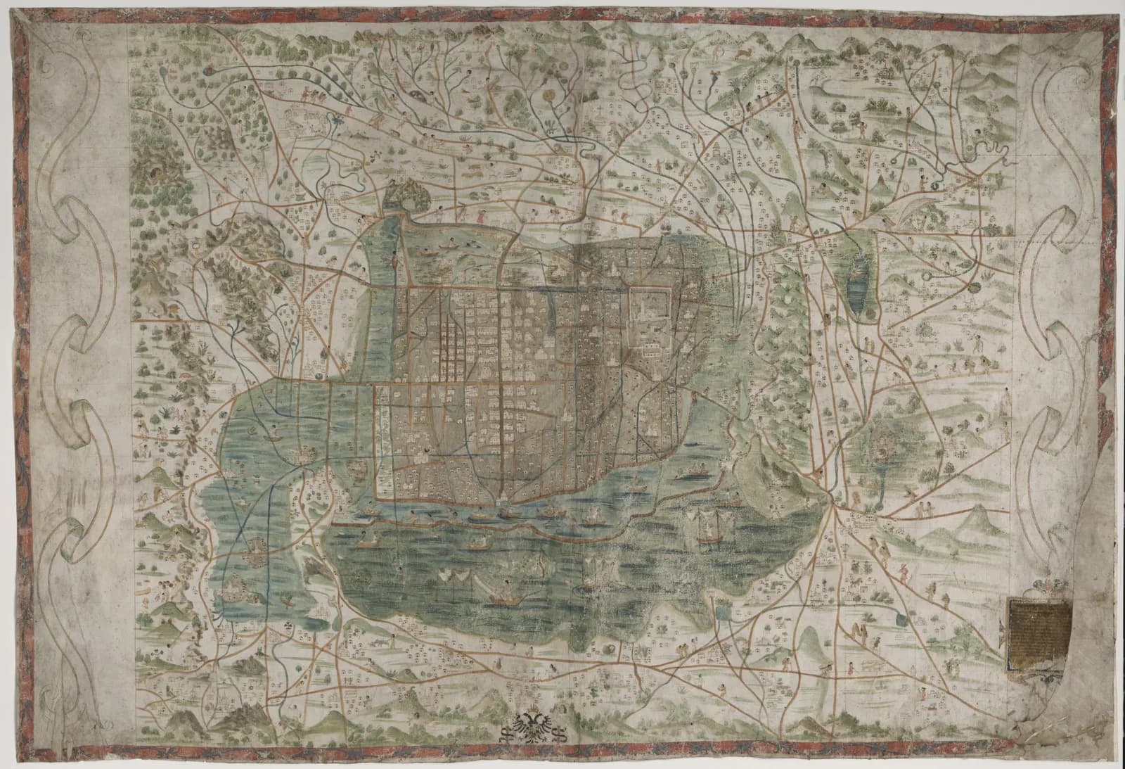
In a library in Sweden there is a painted map of Mexico City. The Uppsala University Library lists it as two pieces of parchment joined together, 75 by 114 centimeters.
A dedication to Emperor Charles V is only partly legible in the lower right corner. Scholars have given the map three different dates and at least two different makers.
The traditional view
The library's own news page says the map was "probably made around 1550." It says the map shows "Tenochtitlán and the surrounding area, as the Aztec capital looked after a few decades of Spanish presence."
The same page adds that "The old temple areas had been demolished and replaced by churches and new houses, but the old street structure and water canals still remained." The library's catalogue record lists the cathedral at the central plaza and Nahuatl symbols for place names.
Miguel León-Portilla and Carmen Aguilera published a book on the map in 2016. A UNAM science page describes it as made around 1550, "apenas a treinta años de la Conquista." That means barely thirty years after the Conquest (my translation).
They write that it was made "muy probablemente en el Colegio de Santa Cruz de Tlatelolco por un tlacuilo mestizo o por un indígena recientemente aculturado." In my translation the maker was most probably a mestizo painter or a recently acculturated Indigenous man, working at the Colegio.
Mariana Favila Vázquez summarizes the content in Investigaciones geográficas. She writes that the sheet is oriented with the north-south axis horizontal. It shows the island of Mexico-Tenochtitlan and lakeside towns up to 40 kilometers away. She adds that roads and canals link the island to other places in the Valley of Mexico.
She also reports that Spaniards and Indians appear at work, and that the map carries more than 200 place glyphs. I did not see the 2016 book itself.
The map carried the name Santa Cruz for a long time. Favila explains that the name of the cosmographer Alonso de Santa Cruz appears on the cartouche in the lower right corner. She adds that Santa Cruz "nunca cruzó el océano Atlántico para visitar Nueva España." In my translation he never crossed the Atlantic to visit New Spain.
For the other famous picture of the city, see the Nuremberg plan. The Library of Congress says that print, dated 1524, depicts the city in 1520. The Uppsala map shows it after the Spanish had built on it.
What the Painting Does Not Say
The Uppsala map is old, painted and rich in detail. The scholars still disagree about when it was painted, who painted it and how far its makers followed European habits.
In Chapter 5 I write that someone before 1513 mapped the Atlantic coastlines with unusual accuracy from older source maps. A painted copy of a lost original is the same kind of question on a smaller scale.
Here is where the researchers stand. Jennifer Saracino's 2018 essay argues against earlier descriptions of the map's composition as one that "has fully espoused European cartographic modes." Her abstract says closer study of its pictorial conventions can show how the artists "might have consciously selected particular pictorial strategies."
John F. López reads the map differently in his 2014 article in Ethnohistory. His abstract says "cartographic elements" in the map "closely resemble those found in Alonso de Santa Cruz's 1542 world map." He also writes that the city's traza, or urban plan, "was not spatially unitary."
Both abstracts describe Indigenous artists or an Indigenous mapmaker. I have only read the abstracts.
Where They Don't Meet
Three questions stand out. The sources set them out, and none of them answers them.
When was it painted?
The library says "probably made around 1550." Saracino and Barbara Mundy give a different date in the abstract of their 2021 article. They write "the traditional scholarly consensus has been that the map dates to c.1554." Then they "derive evidence from an examination of the original map to argue for a creation date of c.1537-1541."
They add that the earlier date matters. Combined with the map's "high degree of topographical and chorographical precision," it means the map "offers a snapshot of the city's urban development and ecological changes at an earlier point in its history than has been acknowledged." Her 2018 essay had already carried c. 1540 in its title.
Favila puts the limit of what is known plainly. She writes that the map was painted in New Spain, "sin conocerse a ciencia cierta la fecha de su creación." That means the date of creation is not known with certainty (my translation). She also reports that Santa Cruz gave the map to Charles V "antes de su abdicación en 1556," citing Saracino. That sets an upper limit.
I have not read the evidence behind the 1537 to 1541 range. The article sits behind a publisher paywall, and I used the abstract. What on the object itself fixes its date?
Whose hands painted it?
The library's record says modern scholarship points to an Aztec cartographer with European training, not to Santa Cruz. The Fulcrum repository lists the creator as "Unknown."
Favila reports that the link to the Colegio de Santa Cruz de Tlatelolco rests on two points. One is a stylistic likeness to the images in the Florentine Codex, which was made there. The other is that the convent of Santiago Tlatelolco looks larger on the map, apparently to show its importance. Her footnote adds that "las proporciones de este espacio coinciden con sus dimensiones reales." That means the proportions of that space match its real dimensions, "por lo cual ese argumento es debatible" (my translation: so that argument is debatable).
Other accounts name more people. A Nexos article says the makers were "estudiantes y sabios indígenas en colaboración de frailes españoles como, tal vez, Bernardino de Sahagún." In my translation they were Indigenous students and scholars working with Spanish friars, perhaps including Sahagún. A paper at the Museums and the Web conference reports that León-Portilla and Aguilera propose the map was made by "members of the Aztec nobility working under the tutelage of Spanish monks." The León-Portilla text I quoted above says a mestizo painter or an acculturated Indigenous man. I have not checked how the two descriptions line up.
López finds shared elements with the Santa Cruz world map of 1542. Saracino's 2018 abstract argues that the artists chose their pictorial strategies with care.
Was it one painter, a workshop, or a collaboration with the friars?
How did it get to Sweden?
The sources tell different stories. Favila follows León-Portilla and Aguilera. She says the map was sent to Spain and reached Santa Cruz, who sent it to Charles V. She writes that he "pudo, o no, haberlo recuperado" to make the copy he added to his Islario general. That means he may or may not have recovered it (my translation).
She adds that "todo indica" the map then traveled to Prague, "tal vez para ser regalado a Fernando I." That means everything indicates it went to Prague, perhaps as a gift to Ferdinand I (my translation). She writes that "Las hipótesis señalan" it was taken to Sweden during the Thirty Years' War (1618 to 1648). It ended up in the Royal Library and then at Uppsala University.
The library's own record gives another route. It says the map was "likely" acquired by the Swedish linguist Johan Gabriel Sparwenfeld in late seventeenth-century Spain and later donated to the library.
The Nexos article gives a third account. It says the map was in Sweden "por lo menos desde fines del siglo XVIII." Bishop Carl Gustaf Nordin owned it and gave it, with other documents, to King Gustav III. From the Royal Library it moved to Uppsala.
A fourth line comes from a Wikipedia summary. It says the exact whereabouts of the map were lost after it was presented to Charles V until it was rediscovered at Uppsala. I used Wikipedia only to locate sources.
Favila says it was rediscovered at the end of the nineteenth century. Which route did the map actually take?
The questions I can't put down
Some questions need more room than one article gives them. Two of them keep pulling me back.
How much of the valley is on the parchment? Saracino and Mundy call the map precise. López says the city plan was not spatially unitary. Favila reports roads and canals that link the island to towns up to 40 kilometers away. The library says the old street structure and water canals still remained. In the book I ask what older source maps lay behind the Piri Reis chart. The Piri Reis article follows that question through Earthly Enigmas.
How many place names are on it? The publisher's note on León-Portilla and Aguilera's book says the map holds "ciento veinte glifos toponímicos" around the lakes, which means 120 place glyphs. The Museums and the Web paper says almost 200. Favila says more than 200 and adds that some are legible, some carry a gloss and some are "simplemente indescifrables," or simply undecipherable. The Codex Quetzalecatzin article and the Oztoticpac Lands Map article look at other Nahua sheets with place glyphs. You can read a free sample of the book before you decide. The articles section has more subjects in the same format.
Sources
- Uppsala University, Unique 16th century map exhibited in Mexico City (news, 2021) (read through a fetch tool excerpt)
- Uppsala University Library, Alvin record 85478: Map of Mexico City ca. 1550 (read through a fetch tool excerpt)
- Mariana Favila Vázquez, Tornaviaje de un mapa del siglo XVI a la capital de México, Investigaciones Geográficas 107 (2022) (read in full, open access)
- Jennifer Saracino and Barbara E. Mundy, Dating the Mapa Uppsala of Mexico-Tenochtitlan, Imago Mundi 73:1 (2021) (abstract only)
- Jennifer Saracino, Indigenous Stylistic and Conceptual Innovation in the Uppsala Map of Mexico City (c. 1540), Artl@s Bulletin 7:2 (2018) (abstract only)
- John F. López, Indigenous Commentary on Sixteenth-Century Mexico City, Ethnohistory 61:2 (2014) (abstract only)
- Ciencia UNAM, Mapa de México-Tenochtitlan en el nuevo libro de Miguel León-Portilla (read through a fetch tool excerpt)
- Amoxcalli, Parution: Mapa de México-Tenochtitlan y sus contornos hacia 1550 (publisher's note) (read through a fetch tool excerpt)
- Nexos, El Mapa de Uppsala: la historia de un gran tesoro mestizo (read through a fetch tool excerpt)
- Acuña and Diaz, The Digital-Signs in the Map of Mexico 1550, Museums and the Web 2010 (read through a fetch tool excerpt)
- Fulcrum: Uppsala Map of Mexico-Tenochtitlán ca. 1550
- Wikipedia: Santa Cruz Map (used to locate sources and to relay the lost-whereabouts line, which I have not checked)
- Library of Congress: Tenochtitlán, 1521 (World Digital Library record 2021668313) (I could not open the record, so I have not quoted it)