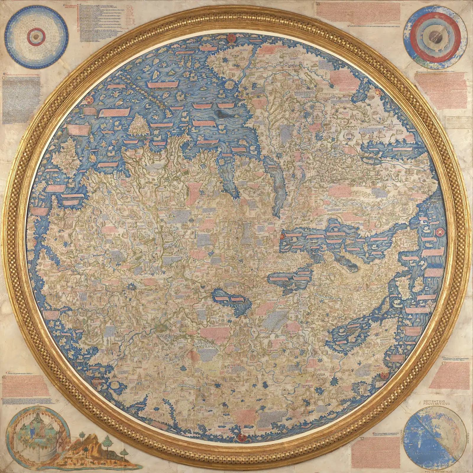
The map is a circle 196 centimeters across set inside a square frame 223 centimeters on a side. South is at the top. Thousands of written notes crowd the painted world.
The Biblioteca Nazionale Marciana in Venice, which keeps it, says the name of the author appears nowhere on the object.
The traditional view
The Marciana describes the map in its own record. I translate from the Italian. It says the Camaldolese monk Fra Mauro made it in the map workshop of the monastery of San Michele di Murano in the middle of the fifteenth century. The central circle is painted on four sheets of calf parchment glued onto three poplar boards.
The Museo Galileo's digital edition says the map brings Ptolemy's Geography and sea charts together with thousands of descriptive texts and hundreds of images. It names the sources of the notes. They include Ptolemy, Pliny, Marco Polo, Niccolò de' Conti, Ethiopian monks who visited Venice and other anonymous witnesses.
The same edition says the map has no scale of distances and no rhumb lines. It marks neither the equator nor the tropics. The only directional elements are eight wind roses around the edge.
Christoph Mauntel writes in a 2018 article in Peregrinations that the Portuguese king Alfonso V commissioned a map from Fra Mauro in the late 1450s. He adds that the map now in the Marciana was presumably drawn for the Venetian Signoria.
The Museo Galileo says the Portuguese court paid the monastery 28 ducats for a copy between 1457 and 1459. It adds that Bartolomeu Dias reached the southern tip of Africa in 1488, "precisely as Fra Mauro had foreseen."
What the Map Leaves Open
In Earthly Enigmas I write about the Piri Reis map in the chapter called "Knowledge of the Entire Globe." I say that someone, before 1513, had mapped the Atlantic coastlines with unusual accuracy. You can read how I and the experts handle that question in the Piri Reis article.
Where the Sources Part Ways
Both views lean on questions the evidence cannot yet answer. Three of them stand out.
Which map is the one in Venice?
The Marciana gives no author's name for the object and dates it only to the middle of the fifteenth century. The Museo Galileo says the Portuguese copy was "perhaps the very one now in the Marciana Library."
Mauntel says the surviving map was presumably drawn for the Signoria. A Google Arts and Culture story, adapted from a catalog text by the Spanish National Geographic Institute, says something else. It says the map was completed on April 24, 1459, sent to Portugal and later lost.
The same story says Fra Mauro died two years later while making a copy for the Signoria and that Andrea Bianco finished it. Mauntel says Fra Mauro died around 1459. The Museo Galileo gives his working years as about 1430 to about 1459 or 1464.
I have not checked any of these dates against the documents. Which map is the one in Venice, and when was it finished?
Where did the news come from?
The Museo Galileo says Fra Mauro drew on older maps and then says it cannot be certain how he reached such detailed information. The interior of Africa came from maps made for him by Ethiopian monks in Venice. Of those maps, the Museo says, "no trace remains."
The Museo adds that Giovanni Battista Ramusio claimed Marco Polo's maps were another source. It says historical research has been unable to confirm that.
Fra Mauro gave his own account in a note on the river Don. In Falchetta's edition the Italian reads "E chi volesse contradir sapia che questo ho da persone dignissime che hano veduto ad ochio." In my translation he tells any doubter that he has it from most worthy people who saw it with their own eyes. On the question of the continents he told readers he would "leave the prudent to decide," in Mauntel's translation.
Wikipedia's article on the map says Piero Falchetta notes many facts that have no source in any other surviving Western map or manuscript of the period. I have not checked that in Falchetta's book.
What did those maps and those witnesses say, and where are they now?
Who sailed beyond the Cape of Diab?
A long note on the southern tip of Africa describes a voyage. As Wikipedia translates it from Falchetta, "Around 1420 a ship, or junk, from India" crossed toward the Island of Men and the Island of Women off Cape Diab. It "sailed for 40 days in a south-westerly direction without ever finding anything other than wind and water."
The same translation says the ship went some 2,000 miles ahead and then turned back, reaching Cape Diab again in 70 days. A second note has Fra Mauro saying he spoke with a person worthy of trust who had made such a voyage. I have not checked either translation against the Italian.
The Museo Galileo reads the voyage differently in one detail. It says Chinese junks traveled over 2,000 miles to reach the southern coasts of Ethiopia. It says Fra Mauro joined that report to Portuguese navigation and concluded that Africa could be sailed around. It calls this an intuition that anticipated Dias by almost half a century.
Gavin Menzies uses the same note in his case that Chinese treasure fleets sailed these waters in the early 1420s. His maps page says Fra Mauro drew the Cape of Good Hope correctly 30 years before Dias.
Peter Barber, then head of the map collection at the British Library, is quoted in a 2002 Sydney Morning Herald report. He calls the Menzies theories potentially dangerous. The report also says Professor Luo Zongzheng of the Nanjing Museum reportedly told Menzies that Zheng He has too many theories. He added that there are no relics, boats or anything concrete. I have not read either man's own work.
Who sailed beyond the Cape of Diab around 1420, and what did they find?
The questions I can't put down
Some questions need more room than one article gives them. Two of them keep pulling me back.
How big did Fra Mauro think the world was? A note on the map gives circumference figures of 22,500 or 24,000 miglia and says they have not been tested. I have only seen that wording on Wikipedia and have not checked it in Falchetta's edition. In the book I follow the argument that the network of ancient sites needed knowledge of latitude and longitude across the whole planet. I follow that question through Earthly Enigmas.
How accurate was the map, and measured against what? Wikipedia reports that Europe is the most accurate part and that India is split in two. The Herald report says the map fails to depict China accurately. In the book I write about the unusual accuracy of the Piri Reis coastlines. You can read a free sample before you decide. The articles section has more maps in the same format, including the Catalan Atlas and Al-Idrisi's World.
Sources
- Biblioteca Nazionale Marciana: Il Mappamondo
- Museo Galileo: Fra Mauro's world map, digital edition (introduction)
- Museo Galileo: The World Map
- Museo Galileo: Cartographic Sources
- Museo Galileo: From the Mediterranean to the Indian Ocean
- Museo Galileo: Portuguese Expansion in Africa and into the Indian Ocean
- Christoph Mauntel, Fra Mauro's View on the Boring Question of Continents, Peregrinations 6.3 (2018)
- Google Arts and Culture: Fra Mauro's Mappa Mundi (adapted from a Spanish National Geographic Institute text; secondary)
- Gavin Menzies: Maps
- Sydney Morning Herald: Found in the junk (2002) (news report; secondary)
- Wikipedia: Fra Mauro map (secondary, used to locate sources and for the English wording of two notes from Falchetta's edition)