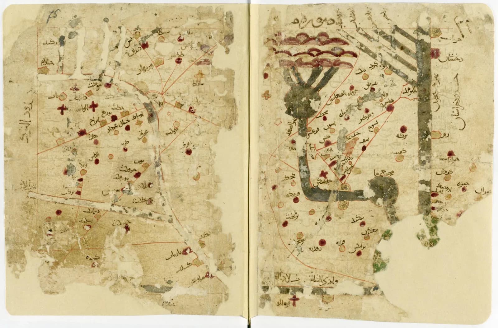
The Gotha manuscript has 75 folios and 21 color maps. It was written in 569 in the Islamic calendar, which is 1173 in ours.
The geographer it copies worked about two centuries earlier. Emilie Savage-Smith writes that the earliest dated copy of his book comes from the twelfth century.
The traditional view
Al-Istakhri wrote a geography of the Islamic lands in the tenth century. The Gotha Research Library says he wrote it in the first half of that century. The library adds that the oldest extant mapped work of its kind can probably be traced to him.
The Gotha copy carries the title Kitab al-Aqalim. The library says the title refers to a work by al-Balkhi, which is lost. Al-Istakhri largely quoted, commented on and corrected it.
The library describes 21 maps. They are a map of the world, three maps of the Mediterranean, the Indian Ocean and the Caspian Sea, and 17 maps of regions from Morocco to Transoxania. The library says the book pays particular attention to the Persian provinces and Transoxania. It gives the origins of the two writers and the patronage of the Samanid rulers as the reasons.
UNESCO placed the work on its Memory of the World Register in 2015. The nomination came jointly from Germany and Iran. It covers the Gotha copy and a Persian translation copied in 1325, which the National Museum of Iran holds.
The nomination form calls the Gotha copy the oldest known manuscript of the work in its Arabic original. It lists 150 pages, 75 folios and a page size of 25.0 by 19.0 centimeters. According to the library, the explorer Ulrich Jasper Seetzen acquired the copy in Cairo in 1807 for the Dukes of Saxe-Gotha-Altenburg.
Gerald Tibbetts wrote the chapter on this tradition in the History of Cartography. He says Moeller published the Gotha copy in facsimile in 1839, so European scholars knew it better than the copy in Istanbul. The nomination form says de Goeje based his 1870 critical edition on it. That edition had no maps.
A second Arabic copy at the National Maritime Museum in Greenwich is dated before 1282 by an ownership inscription. The museum lists 17 maps.
Tibbetts describes how the maps look. Most lines are straight or arced, rivers are wide parallel lines and lakes are often perfect circles. He writes that "there is no projection to form the base of the map."
What the Evidence Does Not Settle
In Earthly Enigmas I treat the Piri Reis map as drawn from older source maps that have not been found. In Chapter 5 I write that someone had mapped the Atlantic coastlines with unusual accuracy before 1513. I also write that a global network requires global knowledge.
What the Copy Does Not Say
Both views lean on questions the evidence cannot yet answer. Three of them stand out.
Whose maps are these?
The title on the Gotha copy points to al-Balkhi, a scholar whose own geography is lost. Tibbetts reports that al-Muqaddasi said al-Balkhi "intended in his book chiefly the representation of the earth by maps." Tibbetts adds that other opinions give the maps to Abu Jafar al-Khazin. He calls the matter "very suspect" because neither al-Khazin's maps nor al-Balkhi's commentary have survived.
Little is known of al-Istakhri himself. Tibbetts calls him "virtually unknown apart from his one work." He says al-Istakhri does not appear in the standard Arab biographies. What is known of him personally comes from Ibn Hawqal's account of a meeting. The Iranian nomination form says al-Istakhri describes places he traveled to and saw directly. I have not checked what the text supports.
Tibbetts reads the maps as the work of the scholars themselves. He writes that each map "is linked directly to the scholar in each case and not added by the copyist." His evidence is Ibn Hawqal's report that the two men compared the maps each had drawn.
Savage-Smith reviewed Nadja Danilenko's 2021 study of the manuscripts. She writes that confusion over what belonged to al-Balkhi, al-Istakhri and Ibn Hawqal "had already begun in the tenth century." She calls the nature of al-Balkhi's work "highly speculative." She also says Danilenko "justifiably challenges" the term Balkhi School and studies the surviving copies instead of their origins.
Karen Pinto's 2016 book Medieval Islamic Maps says it identifies the creators, painters and patrons of these maps. I have read only the book's summary.
The confusion reached the title page of the first English translation. William Ouseley published it in 1800 as The Oriental Geography of Ebn Haukal. Tibbetts says he made it from a Persian redaction of al-Istakhri.
Who drew the first version of these maps, and whose hand is in the Gotha copy?
What were the maps for?
Tibbetts says the maps have no projection and no formal scale. He writes that the authors added up days of travel to size the inhabited world, but "these distances are not recognizable on the map."
He offers two purposes in the same chapter. He writes that the basic purpose of the maps "seems to be to incorporate the caravan routes across the province." Later he says the maps "appear to have been drawn for mnemonic purposes, rather than for any other practical use."
In the translation Tibbetts quotes, al-Istakhri states his plan as "to describe, and to delineate on maps, the various seas." Danilenko's publisher describes a different aim. The Brill description, as repeated in a bookseller's listing, says al-Istakhri "chose a timeless design intended to outlast upheavals." I have not read the book.
The maps also leave things out. Tibbetts says the set covers the Islamic empire of the tenth century. Spain has no separate map and is omitted in the text. He says the scholar Maqbul Ahmad sees a deliberate policy behind this focus.
Savage-Smith cautions that Danilenko's approach "runs the risk of imposing the framework of modern categories on the objects of analysis." She would have liked to know "whether the illustrations/maps in Istakhri's work added data visually."
What did a reader do with one of these maps?
Who held the book before 1807?
The nomination form lists seven entries in the manuscript's history. The first owner it names is Zuhayr al-Muhallabi, a secretary to the Ayyubid ruler al-Salih Najm al-Din Ayyub. The form says "It is assumed that he acquired the manuscript in 1240 in Syria or Mesopotamia."
The copy is dated 1173. The sources I read name no owner for the first 67 years.
The form next names the biographer Ibn Khallikan, who acquired the book from Zuhayr. It then names an unknown owner and a ruler of Yemen called Ali ibn Dawud, who reigned from 1321 to 1363. The fifth name is a scholar called Abd al-Qadir al-Jaziri. The form gives no dates for three of the seven entries.
Seetzen bought the book in Cairo in 1807, according to the Gotha library. The form says it reached the ducal library in 1810.
I have not seen Gotha's own catalog record. Nothing in the sources I read says where the copy was made or who made it.
Where was the book made, and who held it between 1173 and 1240?
The questions I can't put down
Some questions need more room than one article gives them. Two of them keep pulling me back.
How close is this page to the first one? Tibbetts writes that what one really wishes to know is how close to the original version the map in such a manuscript is. He says probably only one extant manuscript was produced within two hundred years of the map it was copied from. The Gotha copy was made about two centuries after al-Istakhri's book. In the book I treat the Piri Reis map as drawn from older source maps that have not been found. The Piri Reis Map article asks where the maps behind it went. I follow that thread through Earthly Enigmas.
What does a map of the whole world have to know? Tibbetts says al-Istakhri draws the world as a circle ringed by the Encompassing Sea. He gives its width as 400 days of travel and the inhabited length from north to south as 210 days. The extreme north and south are uninhabited, he says, because of cold and heat. In Chapter 5 I write that a global network requires global knowledge. Al-Idrisi's World looks at a very different map of the world from twelfth-century Sicily. You can read a free sample of the book before you decide. The articles section has more subjects in the same format.
Sources
- Gotha Research Library: UNESCO World Documentary Heritage, An Arabic manuscript
- UNESCO Memory of the World: Al-Masaalik Wa Al-Mamaalik
- UNESCO nomination form 2014-56, Al-Masaalik Wa Al-Mamaalik
- Gerald R. Tibbetts, The Balkhi School of Geographers, in The History of Cartography, vol. 2, book 1 (University of Chicago Press, 1992)
- Emilie Savage-Smith, review of Danilenko, Picturing the Islamicate World, Imago Mundi 74:1 (2022) (text read on a third-party host)
- Royal Museums Greenwich: Kitab al Aqualim, P/3
- Brill description of Danilenko, Picturing the Islamicate World, as repeated in a bookseller's listing (secondary, publisher blurb only)
- Karen Pinto, Medieval Islamic Maps: An Exploration (University of Chicago Press, 2016), summary on Academia.edu (summary only)