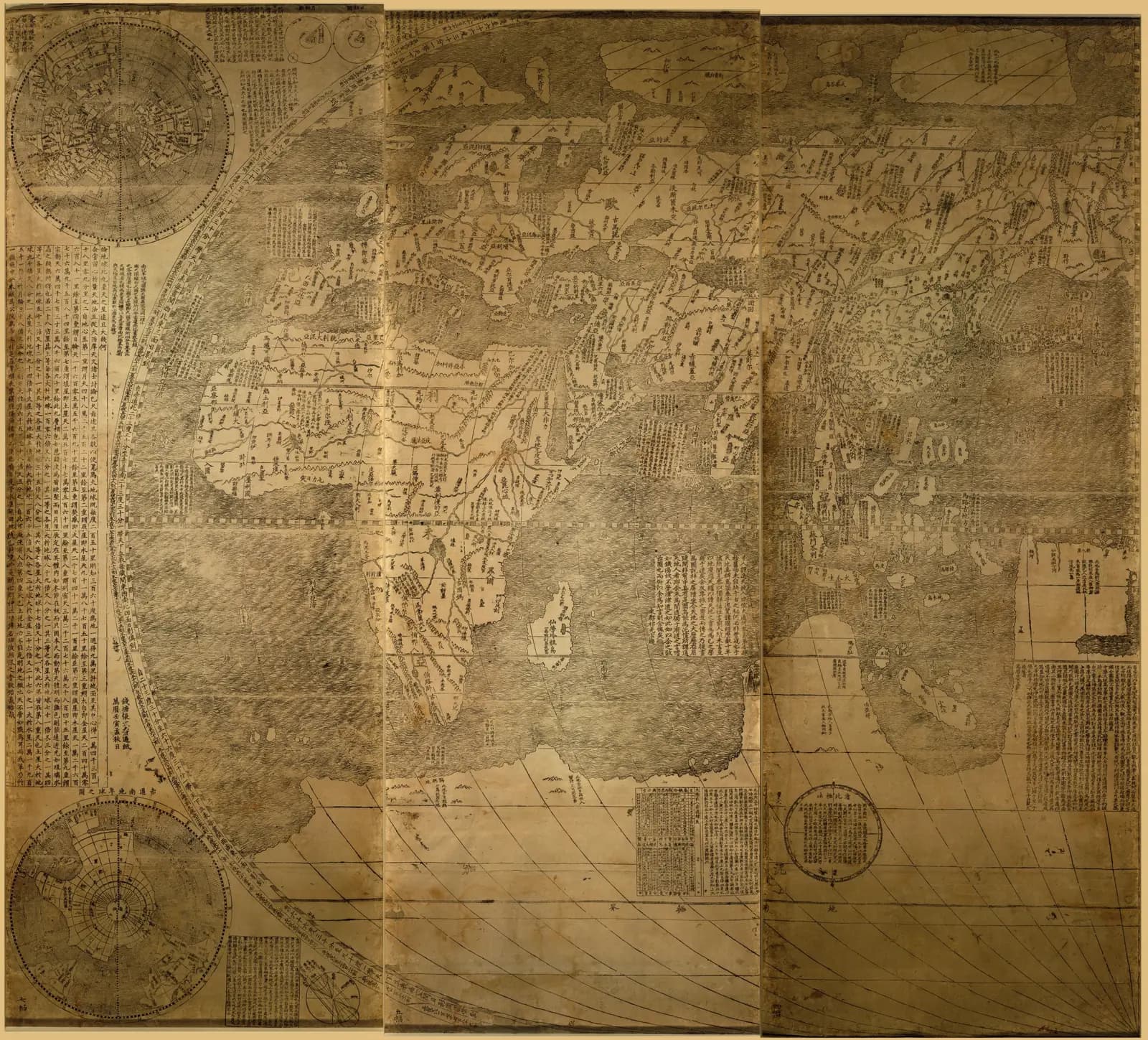
In 1602 six panels were printed in Beijing from carved wood blocks. Joined together they make a world map 5.5 feet tall and 12.5 feet wide.
The Library of Congress calls it the first map in Chinese to show the Americas. The University of Minnesota calls it the oldest surviving one.
The traditional view
The map is called the Kunyu wanguo quantu. The University of Minnesota translates the title as Complete Geographical Map of Ten Thousand Countries. It says the map is a woodblock print on six panels of fine native paper made with bamboo fiber.
Michaela Kästl of the University of Tübingen traces the map back to 1584. In that year the prefect of Zhaoqing, Wang Pan, saw a European world map on the wall of Matteo Ricci's residence. He asked Ricci to "make [the] map speak Chinese." Kästl counts four editions over two and a half decades and says the first is lost.
Minnesota calls the 1602 edition a true collaboration between Jesuit scholars and the Chinese scholars and artisans of the imperial court. It says Li Zhizao, a Chinese mathematician, astronomer and geographer, may have engraved the map. It says Zhang Wentao of Hangzhou printed it.
Kästl writes that most recent scholars agree on the European sources. Ricci used Christopher Clavius and Alessandro Piccolomini for the diagrams of the heavens. Abraham Ortelius and the planispheres of Gerardus Mercator and Petrus Plancius supplied the projection and the shape of the lands.
China came from Chinese sources. Kästl writes that the Jesuits did not survey the land themselves. She says the Great Wall is the only landmark on the whole map that is meticulously traced.
The map puts China near the middle. The Asian Art Museum in San Francisco notes that European maps of the time placed the Atlantic Ocean at the center. On Ricci's map the Americas sit on the right, Eurasia and Africa on the left, and China and the Pacific in the middle. Kästl says this was done by moving the prime meridian from the Atlantic to the Pacific.
In his preface Ricci says the map works "as a tool for travelling while reclining in one's study." Kästl translates that line from the Italian of Pasquale D'Elia's 1938 edition.
The Library of Congress reported that the historian Jonathan Spence described six stages in the making of the map. The Beijing edition was the fourth. In the fifth stage, from 1602 to 1605, the bulletin says printers and others made unofficial copies and sold them widely.
The habit of calling it Ricci's map has its critics. The Royal Geographical Society says the name prioritizes his influence. It says that narrative "marginalises non-European actors."
Maps Made From Maps
In Earthly Enigmas I treat the Piri Reis map as a compilation of older source maps. I write that "Someone, before 1513, had mapped the Atlantic coastlines with unusual accuracy." I say the debate over its southern coast remains open. You can read more in the Piri Reis article.
Ricci's map is a compilation too. The difference is that scholars can name its sources. Ricci says in the preface that he drew on the papers and books he had brought and the notes he had gathered over many years.
What the Accounts Leave Open
The scholars agree on a good deal. They part ways on a few points that bear on what the map is. Three of them stand out.
What happened to the copies that circulated in China?
The bulletin reports that a court eunuch gave Emperor Wanli a color-tinted edition in 1605. Spence, quoting Ricci's journal, said the emperor wanted another, then asked for 12 more, and then for 12 on silk.
Someone in the audience asked Spence what became of the thousands of copies that circulated in China. The bulletin quotes him saying that "No one has found any copies." It says he speculated about self-censorship or anti-Catholic sentiment and that he did not claim to know.
The counts of surviving copies differ by source. Minnesota's catalog entry, which I could read only as a search excerpt, says its map is one of six known complete examples of the 1602 printing. The Asian Art Museum and the Royal Geographical Society also say six. Kästl writes of three to four extant copies. Gianni Criveller's abstract on Academia says two authentic copies of the 1602 edition still exist. I have not checked what each count includes.
The Royal Geographical Society adds that its own copy is a later print, made in or after about 1644. It says a magazine reported in 1874 that no example of the map was known to survive.
Wikipedia, citing a CBC report, says no original example is known in China. I have not checked the CBC report. The Science and Technology Daily says the Nanjing Museum preserves a printed version. It does not say which edition.
What happened to the copies that circulated in China?
Where did the Americas come from?
Kästl writes that the information on the Americas must have come from European source material. The Chinese had not known the continents existed, so she says it was the Jesuits who supplied them.
Siu-Leung Lee reads the map differently. His 2012 chapter, listed on Academia, says the map is "mostly drawn by Chinese prior to 1430." He writes that "Half of the place names in America has no equivalent in European maps." He adds that the geography of western North America, then unknown to Europeans, is labeled accurately with Chinese place names. He concludes that the map is evidence that Ming Chinese circumnavigated and mapped the world more than 60 years before Columbus.
On his Academia page Lee describes himself as a biochemist turned historian and the president of the Zheng He Society of the Americas. I have read his abstract only. The full paper sits behind a login. His reference list includes Liu Gang and Gavin Menzies.
A separate map that Menzies and Liu brought to notice in 2006 is a different object. Geoff Wade's 2007 critique concludes that map "is a modern fake." The South China Morning Post reports that the author Sheng-Wei Wang has analyzed the 1602 map to back up her own claims about the Ming treasure fleet. I have not read her book.
Lee's 2018 paper, Chinese Mapped America Before 1430, says in its abstract that he compared the map with Mercator, Ortelius and Plancius. Has anyone else repeated that comparison?
Was the Earth ever round in Chinese maps?
The Asian Art Museum says Chinese mapmakers had an understanding of the spherical Earth from an early date. It says these ideas "were not sustained." Its Chinese-language text refers to first-century astronomers who compared heaven to an eggshell and the Earth to a yolk.
Kästl reads the record differently. She writes that there is no indication that Chinese mapmakers did in practice consider a round Earth a valid approach. She says the egg-and-yolk theory attributed to Zhang Heng leaves the Earth's shape open to interpretation. In her account sphericity belonged to heaven, and the Earth was described as a flat surface.
The map itself uses the old image. A legend says the land and sea form one globe "like the yolk in a hen's egg which is surrounded by the white." The Science and Technology Daily says the map introduced "the concept of a spherical Earth to China."
A section of Earthly Enigmas is titled Recovering, Not Progressing. Was the round Earth ever part of Chinese mapmaking, or only of Chinese astronomy?
The questions I can't put down
Some questions need more room than one article gives them. Two of them keep pulling me back.
What is the continent at the bottom? The Library of Congress record names the southern land Antarctica. Princeton's map library says a vast southern continent stayed on European maps from the fifteenth to the eighteenth centuries with little or no evidence to confirm it. It traces the idea to Aristotle's argument that the northern land needed a southern counterpart. The Science and Technology Daily says the map's southern land rests on European speculation. The Piri Reis map raises the same question, and the Piri Reis article sets out both readings. I follow it through Chapter 5 and again in Chapter 15 of Earthly Enigmas.
How can a sphere have a middle? Kästl writes that the idea of the Middle Kingdom does not fit a spherical earth, because a globe has no center at all. The map still puts China near the middle, and the Asian Art Museum's Chinese-language text adds that China looks like only a small part of a large world. In Chapter 5 I give a computed fit for a great circle on the globe and I write that anyone can check it. You can read a free sample of the book before you decide. The articles section has more subjects in the same format.
Sources
- Library of Congress: Kun yu wan guo quan tu, catalog record
- Library of Congress: news release on the exhibition (2010)
- Library of Congress Information Bulletin: The Many Facets of Matteo Ricci (May 2010)
- University of Minnesota Libraries: 1602 World Map of Matteo Ricci
- Michaela Kästl, Mapping the Ambiguous: Intercultural Encounters in Matteo Ricci's World Map (Springer, 2024, open access)
- Asian Art Museum: China at the Center, Rare Ricci and Verbiest World Maps
- Royal Geographical Society: Kunyu Wanguo Quantu and knowledge exchange
- Princeton University Library: Terra Australis
- Science and Technology Daily: Kunyu Wanguo Quantu pioneers new cartographic mode (2024) (state-run outlet, secondary)
- Siu-Leung Lee, Zheng He's Voyages Revealed by Matteo Ricci's World Map (Academia, abstract only)
- Siu-Leung Lee, Chinese Mapped America Before 1430 (Academia, 2018, abstract only)
- Geoff Wade, The Liu/Menzies World Map: A Critique (Academia, abstract only)
- Gianni Criveller, Did Ricci put China at the Centre of his World? (Academia, abstract only)
- South China Morning Post: Did Chinese explorers from the Ming dynasty travel to the Americas decades before Columbus? (Jan 2024, headline and summary only)
- Wikipedia: Kunyu Wanguo Quantu (secondary, for the CBC report on copies in China)