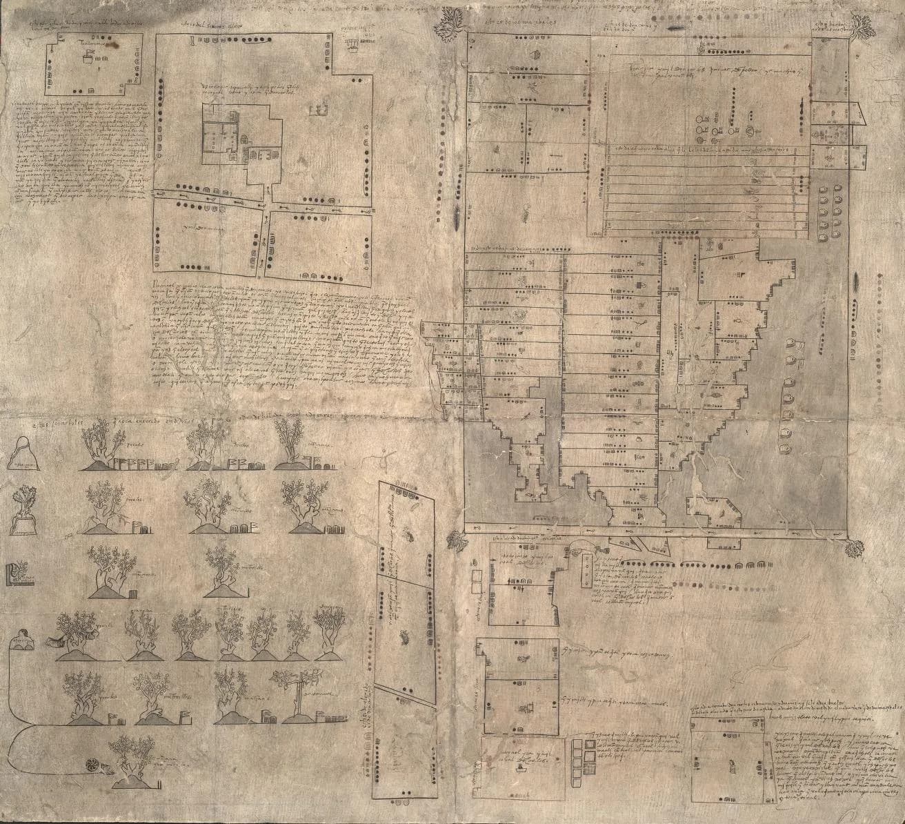
The Library of Congress holds a sheet of bark paper that was drawn for a court. It shows more than 75 plots of land, a plan of several houses and a row of fruit trees with the graft cuts drawn into the trunks.
The man whose property it describes was executed in 1539. The catalog says the outcome of the lawsuit is not known.
The traditional view
The Oztoticpac Lands Map is a Mexican pictorial document with writing in Spanish and Nahuatl. The Library of Congress catalog dates it to about 1540. It gives the size as 76 by 84 centimeters and notes red and black ink and worm holes.
The catalog summary is credited to the World Digital Library. It says the map "relates to a lawsuit concerning the estate of Don Carlos Ometochtli Chichimecatecotl, an Aztec lord and one of the many sons of Nezahualpilli, ruler of Texcoco." Don Carlos was charged with heresy and publicly executed by the Spanish authorities on November 30, 1539.
According to the same summary the litigation began on December 31, 1540. A man named Pedro de Vergara asked the Inquisition to return fruit trees taken from the property of Don Carlos. Other individuals said the land belonged to the family, the lords of Texcoco, as a whole.
The summary adds that the map "most likely was commissioned by Antonio Pimentel Tlahuilotzin, governor of Texcoco, to buttress these claims." A further set of petitioners claimed the Spanish authorities had partitioned the land and that it now belonged to commoners.
The catalog describes the contents. A plan of several houses within a precinct sits near the upper left. The right side holds "more than 75 identified plots, an inventory of landed properties once owned by Don Carlos." The lower left shows European fruit trees and grape vines grafted onto native stock, "the only such image of this agricultural technique known to exist in any Mexican indigenous pictorial document."
The Library's conservation page goes further. It says "As far as is known, this is the earliest recorded lawsuit or conflict in horticultural literature anywhere in the world."
John Hessler spoke about the map in a 2018 Library of Congress webinar. He says the map shows Indigenous people beginning to claim rights in a Spanish court. In his words it shows "the beginnings of a certain accommodation" to Spanish law.
Xavier Noguez reaches a similar view in a report for FAMSI. He calls the map "one of the earliest Indian pictorial documents painted after the Spanish conquest of Central México." He says it shows how the conquered nobility was "using mechanisms of litigation and the presentation of legal evidence within the Spanish system."
Noguez also gives a counterpoint on the Inquisition. He writes that Bishop Juan de Zumárraga "was harshly criticized by the Spanish crown, so much that Indians were removed from the jurisdiction of the Inquisition."
What the Map Was Made to Prove
The Codex Quetzalecatzin article sets out what Chapter 16 of Earthly Enigmas says about the Church and the books of Mesoamerica. This map touches the same institution from another side. It exists because an Inquisition trial ended in an execution. Noguez writes that all of the lord's "worldly goods were confiscated."
What the Sources Do Not Settle
Both views lean on questions the record has not answered. Three of them stand out.
Whose land was it?
Noguez writes that under the Precolumbian system of land tenure "private ownership did not exist." In his reading Don Carlos "enjoyed the income from certain lands" but did not "own" them. The land belonged to the Acolhua nobility in common, and the nobility had to prove it after the execution.
Hessler reads the testimony on the sheet differently in at least one place. He says one parcel is, according to the testimony, "in fact private property." In another place he reads a gloss as saying "The Palace at Oztotipac belongs to the ruling line and not to Don Carlos."
The sheet records its own doubt. Noguez gives a Spanish gloss on a plot at Tollantzinco that reads "this is because it is not certain that Ixtlixochitl gave this to Don Carlos who claimed ownership."
The catalog lists three competing claims. They are Vergara's claim to the trees, the family's claim to the land and the commoners' claim after partition. The outcome of the litigation is not known.
Who did the land belong to, and could the sheet itself settle it?
How large was each plot?
Every plot on the map carries dots around its edge that give its measurements. Hessler says "The surveys are in the Nahua units which are easily convertible to feet and standard units now." He gives the palace precinct as 678 by 633 feet.
Noguez describes a harder problem. He writes that "interpreting the land measuring system still presents a challenge." He adds that "we have yet to discover the formulas for converting the traditional system of land measurement into the modern metric system."
He quotes Herbert Harvey on the sheet itself. Harvey found that "two different standard measures were used, the 2.5 m. quahuiti and a 1.77 m.(?) cemmatl, without any special glyphic warning of the shift." The question mark is Harvey's.
The two statements were made years apart. I have not read Harvey's chapter or Howard Cline's study, and I have not checked whether the field has moved since Noguez wrote.
How large was each plot, and who can confirm it?
Which description fits the sheet?
The published descriptions of one object differ on basic facts. I have not reconciled them.
The catalog gives the size as 76 by 84 centimeters. The Mapas Project agrees. Noguez gives 96 by 105.6 centimeters, and an Internet Archive record repeats his figure.
The dates differ too. Hessler says the map "had to be between late 1539 and sometime in 1540." The catalog says about 1540 and puts the start of the lawsuit at the end of 1540. Noguez says it was prepared between 1540 and 1541.
The place is not fixed either. The catalog names Oztoticpac in Texcoco. Noguez says the map refers to "a still unidentified place very close to the city of Texcoco." Hessler says "Nothing on the map can really be located precisely."
The trees are counted in several ways. The conservation page lists twenty trees "identified as pomegranate, quince, apple, and pear." Noguez adds peach and vineyards. The catalog names peach, apricot and pear grafted onto "apple and cherry trees indigenous to Mexico."
Which of these descriptions fits the sheet, and what would settle it?
The questions I can't put down
Some questions need more room than one article gives them. Two of them keep pulling me back.
Where was the map before 1905? Noguez writes "We do not know how or when the Library of Congress (Washington, D.C.) acquired the Mapa." Hessler says nobody is sure when it arrived. He says it stayed unknown until April 1965, when map mounters at the Library pointed it out. Researchers for a census of Mesoamerican manuscripts found "absolutely no information about the document's history and its provenance." The sheet and the lawsuit both lost their endings. In Chapter 16 of Earthly Enigmas I ask what institutions hold and who can search it, and I follow that question through the Vatican collections.
Who spoke the testimony? Hessler says the Roman-script passages record words given by Texcocans, and he names one speaker. He says the person who wrote them down was "most likely" a cleric. The speakers are named and the writer is not. In Chapter 11 I write about oral tradition and I call it a technology. You can read a free sample before you decide. The articles section has more subjects in the same format.
Sources
- Library of Congress catalog record, The Oztoticpac lands map (LCCN 88690436)
- Library of Congress Preservation, Earliest Recorded Land Dispute: the Oztoticpac Lands Map
- John Hessler, Oztoticpac Lands Map, Library of Congress webinar recorded April 11, 2018 (video and transcript)
- Xavier Noguez, A Facsimile Edition of Mapa de Oztoticpac (FAMSI report, 1996)
- The Mapas Project, Oztoticpac Lands Map (Stephanie Wood, principal editor)
- Internet Archive record, Map of Oztoticpac (secondary description)
- Wikipedia was used only to locate sources and is not cited. I have not read Cline's 1966 study, Harvey's 1991 chapter or Kalyuta's Dumbarton Oaks research report. I know them only through Noguez, the Mapas Project and a search excerpt. The webinar transcript is the Library's auto-generated text.