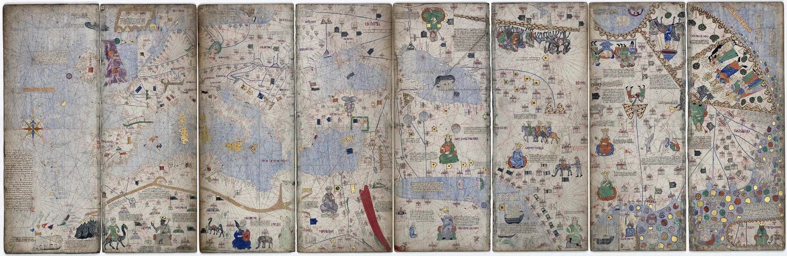
The Catalan Atlas is six sheets of painted vellum. Laid end to end they make a strip about 64 centimeters tall and 3 meters wide.
In the lower left a crowned king holds a scepter in one hand and a golden orb in the other. The caption reads "This Black lord (senyor) is called Musse Melly, lord of the Blacks of Gineua." The atlas carries no signature, and scholars still argue over who made it and where some of its news came from.
The traditional view
The Bibliothèque nationale de France holds the atlas as Espagnol 30. I translate from the French in its essay on the atlas. It says the atlas was in the royal collection of Charles V in 1380 and is attributed to the Majorcan Abraham Cresques. It was made after 1375, a year deduced from the perpetual calendar at the head of the maps, and before November 1380, when the library inventory lists it.
The BnF calls the work both a nautical chart with a compass rose and rhumb lines and a pictorial account of the inhabited regions of the globe. The first two sheets hold cosmology and calendars. The next four make a world map in four parts. Two cover the Orient from China to the Persian Gulf and two cover the Mediterranean West from the Black Sea to England.
The western part is a fairly classic portolan chart drawn to scale and based on the nautical science of its time. The BnF adds that the Atlantic coast of Europe is more precise than on earlier charts. France and the British Isles have become recognizable, although Ireland is greatly enlarged.
The Asian part is much looser. Vladimír Liščák names Marco Polo, John Mandeville and Odoric of Pordenone as the main sources for the eastern parts of the world. The BnF says the east rests almost entirely on Marco Polo's Book of Marvels and that the mapmaker plainly crossed his sources.
The BnF also notes that the king of Mali, with a gold nugget in his hand, is the first Black sovereign to appear on a map.
What the Atlas Leaves Open
Chapter 5 of Earthly Enigmas makes an argument about maps.
I treat the Piri Reis map as one correlation among several in my case for a global network. I read it as a compilation of older source maps. I write that someone, before 1513, had mapped the Atlantic coastlines with unusual accuracy. On the network itself I write that none of this is possible without global knowledge.
The Catalan Atlas draws the Atlantic coast of Europe and a set of Atlantic islands more than a century before 1513. Whether it belongs in that argument is not something the book says.
Where the Sources Part Ways
Both views lean on questions the evidence cannot yet answer. Three of them stand out.
Who made it, and which document says so?
The BnF names Abraham Cresques as the maker. It then writes that this attribution rests on two pieces of information that cannot agree.
The first is the inventory of the library of Charles V, which lists the atlas in 1380. The lines the BnF quotes from it describe a sea chart in panels and name no maker. The second is a note of November 1381. Prince John of Aragon wanted to send Charles VI a world map from the archives in Barcelona. He ordered a search for its author, "Cresques lo juheu qui lodit mapamundi a fet," who was to give all the useful information. If Cresques could not be found, two sailors able to stand in for him were to be asked.
Liščák says the atlas was "attributed, though without certainty, to Cresques Abraham." He adds that in 1375 Cresques Abraham and his son Jehudà received an assignment from Prince John to make a full series of nautical charts. He cites a general book by Baltasar Porcel for the payments. I have not checked that book or the documents.
François-Xavier Fauvelle writes in a footnote that "The Catalan Atlas being unsigned, there is still some uncertainty over its authorship." Katrin Kogman-Appel names Elisha ben Abraham Cresques as the primary maker, according to a review in The Medieval Review. The reviewer adds that she accepts that several makers were involved. He also says the literature on the surviving maps "often lacks consensus in attributions and dates."
Liščák gives the dates of Cresques Abraham as 1325 to 1387. The maker in Kogman-Appel's title has the same dates under the name Elisha ben Abraham Cresques. I have not read her book.
The date is soft as well. According to the Wikipedia article on the atlas, Felipe Fernández-Armesto writes that the atlas is "conventionally attributed to 1375". He adds that 1376 and 1377 also appear in its texts. I have not checked that in his book.
Who made it, and which document says so?
Whose report is the king of Mali?
The BnF says the mapmaker took the positions of the cities Melli, Tembuch, Geugen and Maynia from the traveler Ibn Battuta. It gives the reign of Mansa Musa as 1312 to 1332.
Fauvelle writes in the journal Medievalista about Sijilmasa, Taghaza and the City of Mali. He says their placement "follows precisely the route taken by the Tangerine traveler Ibn Battûta" in 1352. He calls this evidence that the mapmaker "had up-to-date information on the whereabouts of Mâli." In the passages I read he does not say the mapmaker read Ibn Battuta.
Fauvelle then raises a second problem. If the mapmaker still believed that Musa was king in 1375, the king "had in fact died at an unknown date around 1335." On either date the king had been dead for about forty years.
Fauvelle offers two routes for the news. Either the mapmaker "borrowed the information from a previous map," or it "had taken a different, longer path to reach him." He adds that Balearic Jewish merchants "could well have heard about Mûsâ of Mâli from fellow Jewish or Muslim correspondents in Cairo."
Ariel Fein, in a Smarthistory essay hosted by the Gilder Lehrman Institute, writes that the ruler images are "not accurate renderings of the historical individuals, but visual markers of distinct political groups." She says the difference between the light-skinned nomad and the dark-skinned trader "suggests accurate knowledge of the region, likely drawn from contemporaneous Islamic maps and treatises."
The Wikipedia article reports that the historian Hadrien Collet has examined the caption as one of the earliest European steps in the making of the Mansa Musa wealth myth. I have not read Collet.
Whose news is this, and how old was it when it reached Majorca?
Which islands are in the western ocean?
The BnF says the Azores, Madeira and the Canaries "no longer hold any mystery" for the Catalan sailors. It adds that the mythical island of Brazil appears in varying places on other maps. Here it "has been assimilated to a known land" and is one with the island of Terceira in the Azores.
Liščák calls the Insula de Brazil mythical and says it "has nothing to do with modern Brazil." He says Angelino Dulcert recorded it first. He also writes that the atlas treats the Atlantic island groups in a way that "is more complete than in any representation of earlier times." That line appears in his paper without a citation.
Alfredo Pinheiro Marques, a historian of Portuguese cartography, writes that the Azores "were discovered in 1427 by one Diogo de Silves." He says the first correct picture of them appears on Gabriel de Valseca's chart of 1439. The chain of imaginary islands on earlier charts he calls the "false Azores." He also writes that "nobody knows anything about this Diogo de Silves" and that "even the date 1427 is questionable."
Marques does not discuss the Catalan Atlas in the paper I read. I did not find a source that sets the atlas islands against the 1427 date directly.
Which islands did the mapmaker draw, and where did he get them?
The questions I can't put down
Some questions need more room than one article gives them. Two of them keep pulling me back.
Why does Africa stop where it does? The BnF says the mapmaker ends the continent without explanation at the course of the Niger. Liščák says the mapmakers preferred "to leave southern Africa blank rather than fill it with the anthropophagi" and other monsters. He also says the rectangular shape of the atlas "must not be taken as evidence on questions such as the extent, form or knowledge of the African continent." On the network I write that none of this is possible without global knowledge. I follow that question through Earthly Enigmas.
Where did the coastlines come from? The BnF says the western part rests on the nautical science of its time. Liščák says earlier charts came first. The Laurentian Portolan of 1351 resembles the atlas, and a chart of 1339 by Angelino Dulcert "also has points of resemblance." The Carte Pisane article takes up where such charts began. The Piri Reis map article sets out the source map question from the side of the book. You can read a free sample of the book before you decide. The articles section has more maps in the same format.
Sources
- BnF Essentiels: L'Atlas catalan
- BnF Essentiels: L'Afrique du nord dans l'Atlas catalan
- BnF Essentiels: L'Asie dans l'Atlas catalan
- Liščák, Mapa mondi (Catalan Atlas of 1375), Majorcan cartographic school, and 14th century Asia (ICA Proceedings, 2018)
- Fauvelle, The imperial capital of Mâli, 14th century (Medievalista, 2024)
- Westerby, review of Kogman-Appel, Catalan Maps and Jewish Books (The Medieval Review, 2021) (review only, the book itself not read)
- Fein, The Catalan Atlas (Smarthistory, 2022, hosted by the Gilder Lehrman Institute)
- Marques, The discovery of the Azores and its first repercussions in cartography
- Wikipedia: Catalan Atlas (secondary, for the Fernández-Armesto and Collet points)