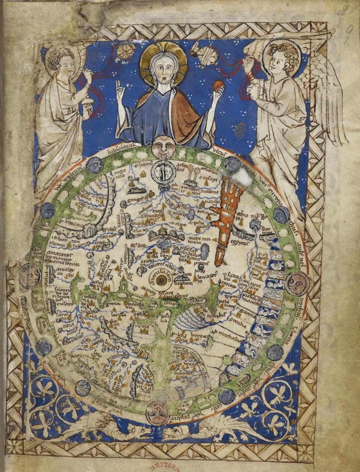
The world map on folio 9r of the Map Psalter is less than ten centimeters across. It names 91 places and carries fourteen monstrous figures along its southern edge.
East is at the top, where Christ presides over the world. The map sits at the front of a Latin prayer book made in England in the second half of the thirteenth century. Specialists still disagree about what it copies and who it was for.
The traditional view
The British Library catalogs the book as Add MS 28681, a psalter titled the Map Psalter with added miniatures. The record says it was made in London in the second half of the 13th century. The calendar commemorates Richard of Chichester, who was canonized in 1262, so the record suggests the book was produced after that date. It gives a date range of 1262 to 1300.
The record describes the map as a round world map in a square ornamental frame, with Jerusalem in the center, a zone of winds and figures of inhabitants. It says the design shares close parallels with the mappa mundi now at Hereford Cathedral. The Hereford article looks at that map.
The back of the same leaf holds a second map. The catalog calls it a diagram of Christ with angels, holding a globe divided into three continents, with the names of the principal kingdoms and cities. LauraLee Brott, in the abstract of her 2018 article in Cartographica, counts 91 place names on the front and 75 provinces and 77 cities on the back. She writes that the two maps are the only mappaemundi extant within a Book of Psalms.
Marta Przygodzka, in an undergraduate journal article, adds that the world map is one of the smallest to survive from the Middle Ages. She describes a T-O construction in which the green Mediterranean divides Europe, Asia and Africa and a ring of winds encloses them. Christ presides above, flanked by censing angels.
Przygodzka, citing P. D. A. Harvey, says maps like this are better thought of as frameworks where information is placed in a spatial position. She contrasts them with modern maps driven by scientific accuracy.
The catalog gives the book's dimensions as 170 by 130 millimeters. A different artist added six full-page miniatures of the life of Christ late in the 13th century, and the record says they were bound in the wrong order. The Resurrection comes before the Crucifixion.
The catalog says a letter of introduction is required to view the manuscript and lists the digital images as currently unavailable. That page is an interim version while the library recovers from a cyber-attack.
The Wall Map Nobody Has Seen
The catalog record has one provenance line about a lost original. It reads "Henry III, king of England (b. 1207, d. 1272) perhaps copied from a wall map in his palace at Westminster." The wording is compressed. I read it as saying the map was perhaps copied from a wall map in his palace. The record cites a 2013 chapter by Nicholas Vincent for the idea, and I have not seen that chapter.
In Earthly Enigmas I write that someone, before 1513, had mapped the Atlantic coastlines with unusual accuracy from older source maps that have not been found. The Piri Reis article sets out that case. In Chapter 11 I call oral tradition a technology, and I list the burning of the Library of Alexandria among the losses.
What The Specialists Cannot Settle
Both views lean on questions the evidence cannot yet answer. Three of them stand out.
Is it a copy of a lost wall map?
Melissa La Porte's 2012 master's thesis at Guelph says the world map may relate to a mural. Henry III commissioned that mural for his bed-and-audience chamber at Westminster Palace. She reports a suggestion that maps tied to that mural form a sub-genre, with the Psalter map and the Hereford map among them. The passage sits in her discussion of Daniel Birkholz, who argues for the political side of such maps.
She then states the difficulty. No copy of the mural survives, which makes it "impossible to know exactly what it would have looked like." She notes that Evelyn Edson earlier suggested a larger wall map as the source without naming the Westminster one.
La Porte writes that Matthew Paris made a copy of the mural map that has also been lost. She calls it possible that the Psalter maps were based on that copy. She says the mural was destroyed or badly damaged in a fire about 1263. I have not checked any of that against the royal records.
She also writes that there is "no way to know if it is truly unique" or part of a larger tradition of similar maps. In one place she names both the Westminster murals and the Great Hall at Winchester as possible sources.
The Wikipedia article on the map says the Psalter, Hereford and Ebstorf maps are all said to reflect a master map in the great hall of Westminster Palace. It adds that little suggests the Psalter map was used by Henry III or someone close to him beyond the similarities. I have not checked that. La Porte places the mural in the king's chamber rather than the great hall.
What would count as evidence that this map copies one particular lost wall?
Who was the reader?
La Porte offers two possible uses. The maps could have taught geography, history and mythology to a student or a scholar. The patron could also have seen Henry III's mural and wanted a version of his own. She adds that the maps may simply have been made "for their own sake."
She points to a kneeling Benedictine monk in the initial for Psalm 101 and to a Benedictine litany. She says the book may have been made for that monk. The catalog adds that the litany includes Worcester saints and that prayers near the front are for a masculine supplicant.
Brott reads the maps through the psalms. Her abstract proposes that they allude to the content of the psalms and complement the images in the historiated initials, cultivating exegesis, prayer and contemplation. In a note she observes that the Hereford and Ebstorf maps are sometimes called teaching tools because of their size. She says the Psalter maps' small size "renders them inefficient for widespread pedagogical use." I saw that note only in the reference list shown on Academia.
Przygodzka reads the map as a device about belonging. She argues that it places the monstrous peoples at the southern edge and also places them inside God's plan of salvation. She suggests that England's own place on the outer ring connects it to that edge.
Mirko Grčić says in his abstract that the maps express biblical symbolism and Christian cosmology and serve as a reminder in devotional practice. I have seen only the abstract.
Who was the reader, and what did the map do for them?
What is the list on the back for?
The catalog describes the back of the leaf as a diagram of Christ holding a globe. Brott, Przygodzka and La Porte call it a list map or a text map. The scholars also differ on what the list does.
La Porte says it may be in part a reference guide. Some names on the list do not appear on the front, among them Gascony, Neustria and Francia. She writes that the names may be ordered to match their place on the map, or they could follow a travel route from the south-east to the north-west.
Przygodzka notes that the Africa section is unusual in how it treats climate and natural features. She reports that its closing line, partly legible because of damage, says in outer Ethiopia there are monsters. She reads that line as tying the list to the band of monstrous figures on the front.
La Porte's abstract says that putting the two maps on the same leaf emphasizes their connection. She calls one map textual and the other visual.
Why put a picture on one side of a leaf and a list on the other?
The questions I can't put down
Some questions need more room than one article gives them. Two of them keep pulling me back.
Why is Jerusalem in the middle? Przygodzka ties the placement to Psalm 73:12, where God "hath wrought salvation in the midst of the earth." Brott's note list ties it to Ezekiel 5:5. In the book I write about the Temple Mount in Jerusalem. I say the platform rests on a megalithic foundation older than Herod's building, and that nobody has established who set the 570-ton Western Stone there or when. I follow that question through Earthly Enigmas.
What is the wall in the north-east holding back? Przygodzka writes that the prominent wall was built to trap Gog and Magog, and that in the Alexander Legend a huge wall contains them. She says that what remains on the map is the wall. In Chapter 11 I write that oral tradition is a technology and that it preserved coastlines and astronomy for thousands of years. You can read a free sample before you decide. The articles section has more subjects in the same format.
Sources
- British Library: Add MS 28681, Psalter ('The Map Psalter') with added miniatures (catalog record)
- Przygodzka, Monstrous Races in the Medieval English Psalter World Map, Groundings Undergraduate 15 (2024) (undergraduate journal, full text read)
- La Porte, A Tale of Two Mappae Mundi: The Map Psalter and its Mixed-Media Maps (University of Guelph master's thesis, 2012) (unpublished thesis, read in part)
- Brott, The Geography of Devotion in the British Library Map Psalter, Cartographica 53.3 (2018) (abstract and note list as shown on Academia; body not read)
- Grčić, Geographical image of the world in the London Psalter Maps from the 13th century, Zbornik radova 69 (2021) (abstract only)
- Wikipedia: Psalter world map (secondary, for the master map statement and for locating sources)