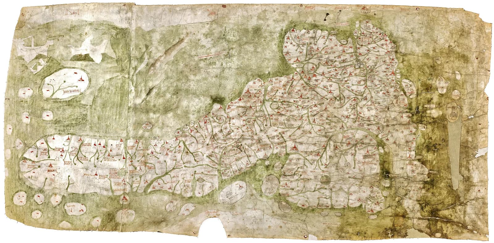
Richard Gough bought it for half a crown in 1774. The sale catalog called it "a curious and most ancient map of Great Britain."
It is drawn on two sheepskins joined down the middle. The Bodleian says the left skin shows what appears to be the backbone and ribcage of a lamb.
Nobody agrees when it was made. Nobody agrees what it was for.
The traditional view
The map now sits in the Bodleian Library in Oxford. The library says it arrived in 1809 with Richard Gough's bequest. In its conservation account the Bodleian dates it "approximately 1360" and calls it "the earliest surviving map to show routes across Britain and to depict a recognisable coastline."
The sheet measures about 553 millimeters by 1,164 millimeters. East is at the top. Towns are drawn as small buildings with red roofs and London gets the most elaborate one. Many settlements are "joined by straight red lines with roman numerals indicating distances."
Keith Lilley, Christopher Lloyd and Bruce Campbell counted 654 cities, towns, villages, castles and monasteries on it. They call it "the earliest extant depiction of the island in geographically recognizable form." The Institute of Historical Research adds more than 800 place names and 200 natural features, mostly rivers.
For a long time the red lines were read as roads. Linda Godden, who runs an independent site on the map, writes that Richard Gough took them for a road network. She adds that Frank Stenton later suggested most of the settlements stood on important roads, although "he provided no supporting evidence."
Gough published a reduced engraving of the map in 1780. The research team says he also applied a reagent to make the place names readable, and that it did damage.
In 2012 a group of historians and scientists called the Gough Map Panel began to study the sheet itself. They used high resolution digital images, hyperspectral analysis, three-dimensional analysis and Raman pigment analysis. Their 2017 paper in Imago Mundi says the map is a sophisticated image from a time when detailed regional maps were almost unknown in Europe.
A Map With No Parent
The Panel found pinholes across the parchment. The Institute of Historical Research reports that the first map was copied from an older map "about which nothing is known." The copyist pricked the position and type of each place sign through from the older sheet.
Godden writes that the Gough Map "had no immediate precedent." I have not checked that claim.
In Chapter 5 of Earthly Enigmas I treat the Piri Reis map as a compilation of older source maps. I write that someone, before 1513, had mapped the Atlantic coastlines with unusual accuracy. The Gough Map has a gap of its own behind it. Whether the two belong in the same conversation is not something the book says.
What the Specialists Cannot Settle
Three questions stand out. Each one rests on published work by specialists who disagree with each other.
When was it made?
The Bodleian conservation page dates the map to about 1360. I do not know when that page was last revised.
T. M. Smallwood wrote a paper on the date in 2010. He says the usual date of about 1360 "is, in the author's opinion, wrong." He reads the writing as "essentially in a hand of about 1400," and he adds that a few features of the handwriting "may suggest a slightly later date."
The 2017 paper by the Gough Map Panel says the map was "variously dated to between 1300 and 1400, and later." It gives the original map as "now dated to c.1400." The Institute of Historical Research uses the same date. Nick Millea, the Bodleian's map curator, is one of the authors.
Godden gives 1390 to 1410, "with later amendments." Michael Ferrar is an independent researcher who publishes on a personal website. He argues for "the earliest c1420AD" and suggests carbon dating both pieces of the leather. I have not checked whether the skins have been dated that way.
So the published dates run from about 1360 to about 1420. What would settle it?
What was it for?
Richard Gough read the red lines as roads. A 2007 Bodleian book by Millea carries the title The Gough Map: The Earliest Road Map of Great Britain? The question mark is part of the title.
Godden quotes Millea calling the red lines "graphic devices to indicate distances, rather than representations of existing highways." I have not seen that line in Millea's own book. The Factum Foundation, which scanned the map in three dimensions, says it was "formerly and mistakenly regarded as the earliest road map of the country."
Lilley, Lloyd and Campbell offer a different answer. They write that interest in the roads meant the settlement geography "has not received the attention it merits." The point of the map, they say, "may have been missed." Their preliminary conclusion is that the original role lies in "its accurate but selective depiction of the settlement geography of fourteenth-century Britain."
Catherine Delano-Smith writes that the map was "created from the start as a working map, to be laid on a table, consulted, and constantly amended." She adds that "By and for whom, and for what purpose, remains to be discovered."
Ferrar quotes the historian P. D. A. Harvey comparing it with portolan charts. Harvey writes that "all that was needed for the Gough map to serve its purpose was a diagram of the road network." I have not checked that line in Harvey's text.
The 2017 paper says nothing is agreed about the context of the map, ecclesiastical or secular. Was it a guide for the road, a record of the places or a tool for a table?
Where did its positions come from?
The research team says the first drawing was copied from an older map by pricking through the parchment. Bove, a member of the project, writes that the pricking marks "the location and form of place signs copied through from a precursor map."
Smallwood takes a different line on one older proposal. He writes that arguments for an earlier "prototype," reflecting the affairs of King Edward I, "are also found to be without merit." I cannot tell whether he means the same older map the pinholes point to.
Lloyd and Lilley tested the placement of places on the map. They found "a considerable degree of spatial accuracy." They also found "marked variations" between England, Scotland and Wales, and they conclude that the map is "a composite of multiscale representations of places in Great Britain."
Ferrar reads it differently. He writes that the map "appears to be visually a geographical map of Britannia" but "it is not," and that "the errors within the map far outweigh the visual pleasantry." He traces the data to a Roman survey and to Ptolemy's Geography. I have not checked his Roman survey claims. His page is not a peer-reviewed paper, and I include it because it holds a dissent the journals do not.
Where did the positions come from?
The questions I can't put down
Some questions need more room than one article gives them. Two of them keep pulling me back.
Why is Wales so far off when the southeast is so close? Godden calls the map "noted for its remarkable accuracy, particularly in south east England." David Bower titled a paper on it "The Medieval Gough Map, Its Settlement Geography and the Inaccurate Representation of Wales." I have only read the first lines of his abstract. One sheet carries very unequal knowledge. In Chapter 5 of Earthly Enigmas I follow the question of older source maps through another map. The Piri Reis article sets out that debate.
How many hands worked on it? The 2017 paper says the original map "although never completed" was reworked on two occasions in the fifteenth century. The Bodleian says a lighter ink north of Hadrian's Wall gives that area an "unfinished appearance." You can read a free sample of the book before you decide. The articles section has more maps in the same format, including the Catalan Atlas.
Sources
- Bodleian Libraries, The Gough Map conservation project
- Catherine Delano-Smith, Understanding the Gough Map (Institute of Historical Research, 2019)
- Delano-Smith and others, New Light on the Medieval Gough Map of Britain, Imago Mundi 69.1 (2017), abstract
- T. M. Smallwood, The Date of the Gough Map, Imago Mundi 62.1 (2010), abstract
- Lilley, Lloyd and Campbell, Mapping the Realm, Imago Mundi 61.1 (2009), abstract
- Lloyd and Lilley, Cartographic Veracity in Medieval Mapping, Annals of the AAG 99.1 (2009), abstract
- D. I. Bower, The Medieval Gough Map, Its Settlement Geography and the Inaccurate Representation of Wales, Imago Mundi 67.2 (2015), first lines of the abstract only
- Factum Foundation, The Gough Map and the Selden Map
- Linda Godden, About the Gough Map (goughmap.uk, independent researcher)
- Linda Godden, Resources (goughmap.uk)
- M. J. Ferrar, The Gough Map; Draughtsmanship, Construction, History (independent researcher, personal website)