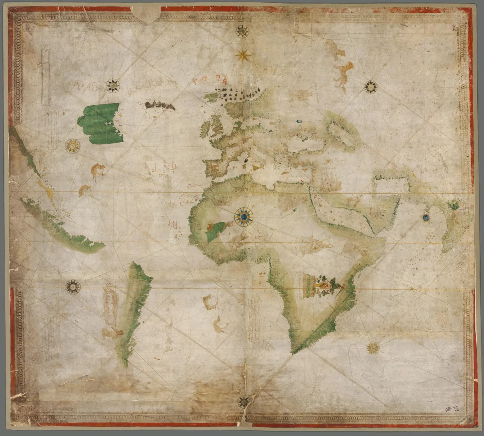
The Bavarian State Library in Munich holds a single sheet of parchment about 99 by 111 centimeters. It carries a painted chart of the world. The chart shows Europe, Africa and Asia, and the new coasts across the Atlantic sit at the left edge.
Over what is now Newfoundland and Labrador the land splits into four narrow strips like fingers. The chart takes its nickname from them.
The mapmaker did not sign the chart or date it. Scholars have called it Portuguese, Italian and Spanish.
The traditional view
The Bavarian State Library catalogs the sheet as Cod.icon. 133. It gives the place as Italy with a question mark and the date as 1502 to 1506. It calls the chart Kunstmann II or the Four Finger Map.
The library says the chart "was copied by an Italian cartographer from a Portuguese original." It says the chart already records the voyages of 1501 by the Portuguese explorer Miguel Corte-Real and the Italian navigator Amerigo Vespucci. Names on the map appear in Latin, Portuguese and Italian.
The library also dates the chart by what is missing. It says Madagascar, which it describes as discovered in 1506, is absent from the map. In its words "it is certain that the chart was made before that date."
The Library of Congress holds a digital copy through the World Digital Library. Its record gives the date as 1502 to 1506. It reuses the Munich description and credits it to Traudl Seifert of the Bavarian State Library.
The name comes from Friedrich Kunstmann, who published thirteen Munich charts in 1859. Alessandro Scafi of the Warburg Institute notes that Kunstmann reproduced only the western part of this one. He says later scholars mostly followed him and read the chart as a record of the discovery of America.
What the Copy Carries Forward
Chapter 5 of Earthly Enigmas makes an argument about maps. Under the heading "Knowledge of the Entire Globe" I treat the Piri Reis map as one correlation among several in my case for a global network. I read that map as a compilation of older source maps. I write that someone, before 1513, had mapped the Atlantic coastlines with unusual accuracy. I also write that "None of this is possible without global knowledge."
Kunstmann II belongs to the same few years as the Piri Reis map. Like that map it was copied from earlier charts, and the specialists argue over which ones. Whether it belongs in my argument is not something the book says. The Piri Reis article covers the chart that names its sources.
Where the Experts Part Ways
Both views lean on questions the evidence cannot yet answer. Three of them stand out.
Who made it, and for whom?
Alida Metcalf of Rice University writes in a 2012 paper that the chart was "most likely made in Spain in the first decade of the sixteenth century." She reads its execution as implying a mapmaker "who had likely travelled to the new world." She raises the hypothesis that Amerigo Vespucci drew it and writes that "sufficient evidence is lacking."
In her 2013 book Mapping an Atlantic World, circa 1500 she says the chart "is considered to be a Spanish (or possibly an Italian) chart." She adds that it was created for or later owned by Cardinal Bernardino López de Carvajal, whose crest appears on the tree in the Garden of Eden over southern Africa.
Scafi's 2008 paper gives the same reading of the crest. He writes that the map was either in the cardinal's possession or, "more likely," made for him. His own figure caption gives the place as Italy with a question mark, the same as the library.
Gregory McIntosh, an independent scholar, reads the chart as Italian work. He calls the assertions by some previous historians that it was a "Portuguese-made map" and that it dates to about 1502 "both probably incorrect." He writes that the language of its Brazilian place names "certainly is not Portuguese." His source is his 2015 monograph on a different chart, the Vesconte Maggiolo map of 1504 in Fano, Italy.
Who drew the chart, in which city, and for whom?
What is it a copy of?
The library says an Italian copyist worked from a Portuguese original. The specialists give a longer chain.
Alegria, Daveau, Garcia and Relaño write in The History of Cartography that the Cantino map of 1502 "established the new African profile that other cartographers hastily copied." They list Kunstmann II first among the copies and date it to about 1503 to 1506.
McIntosh traces the Old World outline from the Cantino chart through the Caverio chart to the Vesconte Maggiolo map of 1504 in Fano. He writes that "The whole of the Kunstmann No. 2 appears to be a copy of the Fano-Maggiolo." Elsewhere he calls it "a servile copy of the same source used by the Fano-Maggiolo." He says the chart is often praised for its "supposedly early Portuguese character."
He also proposes an intermediary map between the Caverio chart and the Fano map and Kunstmann II. He writes that "there is no positive evidence of its existence." In his preface he says "my suggestion remains only a suggestion."
He quotes Henry Harrisse as calling this chart and the Caverio chart "mere copies of copies made by Italian artists." I have not checked Harrisse's text. The Caverio article sets out the arguments over the Cantino and Caverio charts, so I do not repeat them here.
Which chart did the copyist work from, and how many copies stand between that chart and a Portuguese original?
When was it drawn?
The dates in print run across several years. The library says 1502 to 1506. The History of Cartography says about 1503 to 1506. McIntosh says 1504 to 1505. Metcalf says about 1506. Michael Ferrar, who writes the Cartography Unchained site, says the chart is "at the earliest late 1503 and probably 1504." A search result for the MEDEA-Chart database lists 1504 to 1506. The record itself did not load for me.
The end of the range rests on Madagascar. Metcalf dates the chart to about 1506 "mainly owing to the absence of Madagascar."
McIntosh disagrees with the reason. He writes that Ivan Kupčík, following Kunstmann in 1859, "errs in stating Madagascar was not discovered until 1506." He says the Portuguese reached the island in 1500. He adds that "the absence of evidence is not evidence of anything." He allows that the end date "may, in fact, be correct for the map, though for an incorrect reason." I have not checked when the island was first reached.
If the missing island is a weak guide, what fixes the date?
The questions I can't put down
Some questions need more room than one article gives them. Two of them keep pulling me back.
What are the four fingers? Kupčík, as Metcalf quotes him, reads the strips as meaning that "one must assume a mainland of hitherto unknown dimensions." Scafi reads them as a right hand held open, "as if to invite the European to the New World." He ties them to the Tordesillas line. In Chapter 5 of Earthly Enigmas I follow another chart, the Piri Reis map, where one coast is read in more than one way.
What lies under the paint? Ferrar says he found a washed-out ink drawing under the oceans when he enlarged the library's scan. He writes that the sheet "was probably originally a cartoon." He also says a strip about 230 millimeters wide was added along the southern edge. He calls this his working hypothesis. I have not checked either claim, and Ferrar says the library does not offer ink analysis. You can read a free sample of the book before you decide. The articles section has more subjects in the same format.
Sources
- Bayerische Staatsbibliothek: Portulan (Weltkarte), Cod.icon. 133 (MDZ record)
- Bayerische Staatsbibliothek: Hand-drawn maps
- Library of Congress: Portolan Chart (World Digital Library copy)
- Alida Metcalf, Amerigo Vespucci and the Four Finger (Kunstmann II) World Map, e-Perimetron 7:1 (2012)
- Alida Metcalf, Mapping an Atlantic World, circa 1500 (Johns Hopkins University Press, 2013), chapter 6 (read in a third-party copy, quotes need a print check)
- Alessandro Scafi, The African Paradise of Cardinal Carvajal: New Light on the "Kunstmann II Map," 1502-1506, Renaissance and Reformation 31.2 (2008)
- Gregory McIntosh, The Vesconte Maggiolo World Map of 1504 in Fano, Italy, second edition (2015), as posted by the author
- Alegria, Daveau, Garcia and Relaño, Portuguese Cartography in the Renaissance, The History of Cartography vol. 3 part 1 (University of Chicago Press, 2007)
- Michael J. Ferrar, Anon World Chart known as Kuntman II, a Palimpsest? (Cartography Unchained, 2021; self-published)