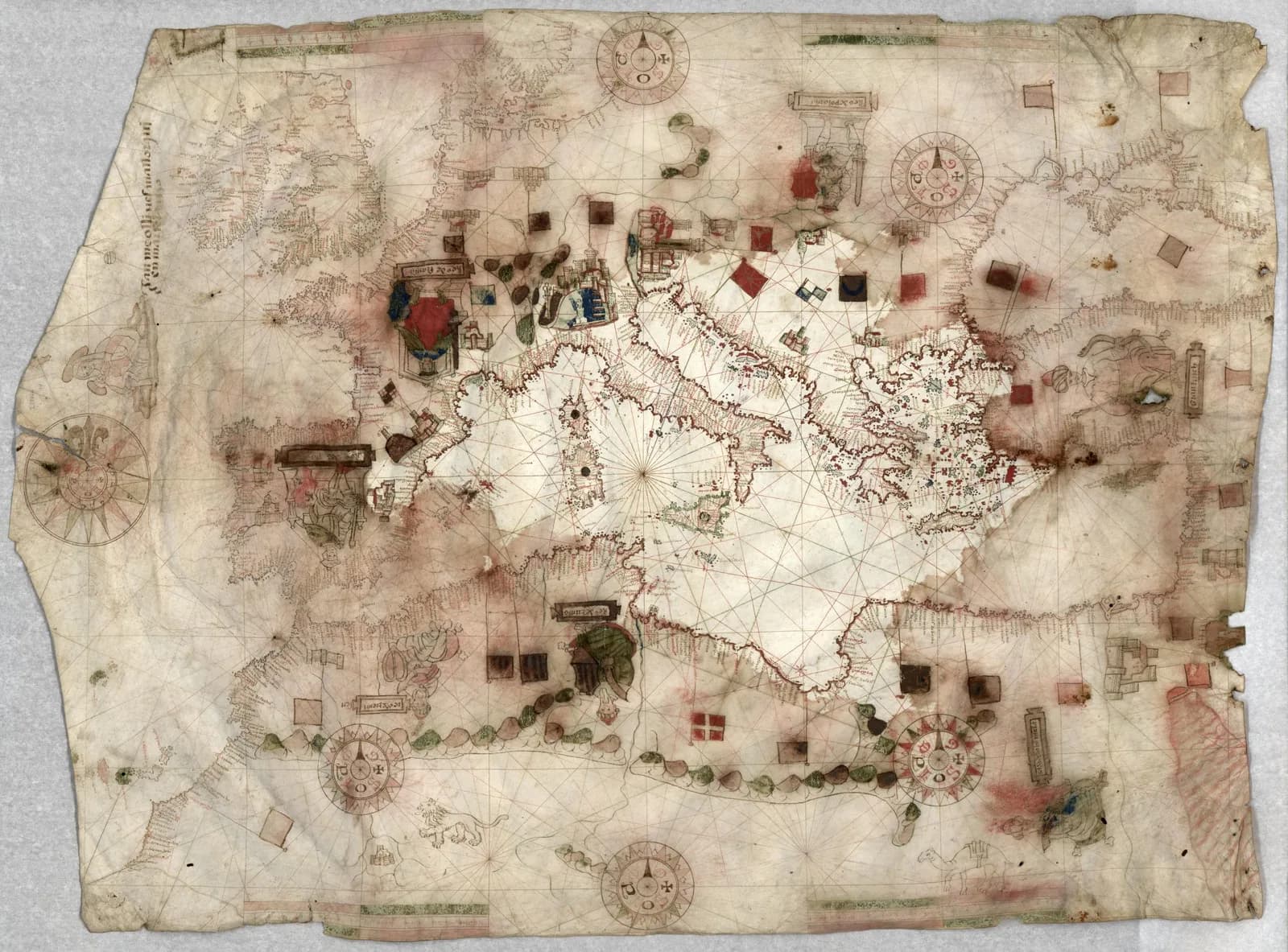
A sheet of vellum 57 by 79 centimeters carries the coasts of the Mediterranean and the Black Sea. A line of Catalan on it reads, in Corradino Astengo's transcription, "jaume Ollives mallorqui en marsela 1550."
The Library of Congress bought it in 1914 from Ludwig Rosenthal of Munich. Specialists still argue over whether anyone ever sailed by it.
The traditional view
The Library of Congress guide to portolan charts says the first maritime charts were produced in the late 13th century. It says a portolan chart is easily recognized by the network of rhumb lines. Those lines "emanate from a compass rose and show lines of bearing which a sailor could use to plot a heading."
Corradino Astengo wrote the chapter on Renaissance Mediterranean charts in The History of Cartography. He calls Jaume Olives the head of a "veritable dynasty" of chart makers from Majorca. Olives signed all of his works "Mallorqui." Astengo writes that his first known work was made in Marseille in 1550, "when the city had no known cartographic workshop." In 1552 he went to Messina and stayed about a decade. He then worked in Naples, returned to Marseille and ended in Barcelona.
The Library of Congress record gives the imprint as "En Marsela : Jaume Ollives, 1550." It lists the work as pen and ink and gouache on vellum, with the neck to the left, bar scales "with unidentified divisions" and "many illustrations." It names the maker as active from 1550 to 1566.
Michael Ferrar, an independent researcher who has written on the Olives charts, describes this one in a long essay. He lists a Madonna and Child, seven seated kings and large views of Venice and Genoa. He adds that it is "unfortunately water damaged."
What the Signature Does Not Tell Us
Chapter 5 of Earthly Enigmas makes an argument about maps. I treat the Piri Reis map as one correlation among several in my case for a global network. I read it as a compilation of older source maps. I write that someone, before 1513, had mapped the Atlantic coastlines with unusual accuracy.
A Mediterranean chart signed in 1550 belongs to the same century, and its Atlantic coast is where the two stories meet. Whether it belongs in that argument is not something the book says.
Where the Specialists Disagree
Both views lean on questions the evidence cannot yet answer. Three of them stand out.
If a sailor bought it, did he ever take it aboard?
The Library of Congress guide says portolan charts "were meant for practical use by mariners sailing short distances." It adds that portolans "were also created to be decorative rather than for practical use."
Astengo writes that buyers of ornamental charts "were often those who worked the sea." He then finds it "highly unlikely that these decorative charts could have been used for actual navigation." He also writes that not a single surviving chart of this kind "bears traces of such use."
Water stains are a case in point. Astengo says they usually come with moth holes and rodent damage and point to "neglectful maintenance ashore rather than use on board a ship." Ferrar calls the Library of Congress chart water damaged.
Kevin Sheehan goes further in his Durham thesis. The abstract says "portolan maps were not navigationally useful." It grants that "some evidence suggests portolan maps were used at sea" and calls that evidence "largely circumstantial and unspecific." I have read only the abstract.
The same guide page describes Richard Pflederer's Finding Their Way at Sea. That description says portolan charts "enjoyed an important place in the navigator's sea chest." I have not read the book.
Tony Campbell reads the survivors as a clue. In his essay on the origin of portolan charts he writes that adorned charts "survive in vastly disproportionate numbers compared to the very rare working versions." He says the added decoration points "away from shipboard use towards merchants' offices or the homes of the wealthy." He says the plain working copies were "worn out through use and then discarded."
Astengo reports that Nordenskiöld suggested Olives was himself a sailor who drew charts during long layovers in port. Caraci accepted that idea. Astengo adds that his moves "seem to follow a precise itinerary."
What would show that this particular sheet was ever carried to sea?
Does it show North America?
The Library of Congress record titles the sheet a portolan chart of the Mediterranean, the Black Sea and "the coasts of western Europe and North America." The record says the cataloger supplied that title. Its subject headings and place names list North Africa and Western Europe. North America does not appear among them.
Ferrar describes a chart that runs from the Atlantic coast and the British Isles to the Black Sea and the Red Sea. He puts the Baltic and Norway in the north and the West African coast down to the Rio d'Oro in the south. He does not mention North America. I did not examine the image, so I cannot say which description the sheet supports.
The library's own guide says portolans "could not be used to navigate across large oceans." Astengo writes that large world charts "are rare and limited to the early decades of the sixteenth century." He says the usual output "showed only the Mediterranean area."
Other Olives works reach further west. Vozenilek, who measured the 1563 Olives atlas in Olomouc, reports that its northern Atlantic sheet holds "a series of imaginary islands." They include Illa de brasil, Antilia and the Island of Seven Cities. He left that sheet out of his accuracy tests because it had too few comparison points. Ferrar reads the 1572 Olives atlas as drawing Labrador, Newfoundland and Nova Scotia together as "Tierra de Labrador" from 47 degrees north.
What does the sheet itself draw to the west, and who gave him the information?
How old was the information on the sheet?
A signature and a date tell us when a sheet was drawn. They say less about when its geography was gathered.
Vozenilek found that the 1563 atlas shows Rhodes under the flag of the Knights of St. John. The knights, he writes, "in 1522 (i.e. 41 years before the publication of the atlas) fled to Malta." He concludes that the maps "were not created with focus on temporal correctness and updates."
Ferrar says Olives kept reusing his own patterns. He writes that Olives "is recycling most elements of his charts and atlases." He ties a 1553 Olives chart to a chart by Salvat de Pilestrina from 1511 and calls the older chart Olives's pattern. That is Ferrar's own reading.
Astengo reports a similar view about the Majorcan chart makers in Messina, where Olives worked for a decade. Codazzi, as Astengo summarizes him, held that the outlines of the British Isles and the African Atlantic coast were "fairly up to date." The rest of the coastlines, he held, "are based on models from the previous century." Caraci thought the model showed "no advance on charts more than one hundred years old." Astengo is writing about Joan Martines and other chart makers in Messina. He does not name Olives in that passage.
Campbell quotes Roel Nicolai's conclusion that the geodetic basis of the charts "is far beyond the capabilities of the European Middle Ages." Campbell himself argues that the experience of Mediterranean navigators was enough. The Carte Pisane article sets out that argument in full.
Which part of this sheet was new in 1550?
The questions I can't put down
Some questions need more room than one article gives them. Two of them keep pulling me back.
Who taught Olives his trade? Astengo writes that "We know nothing about his period of apprenticeship." Ferrar counts an 18 year gap between Olives's likely training and his first dated chart, and that count is his own. In the book I follow a different chain of hands. Chapter 11 describes "a chain of preservation" that is "an imperfect and demanding effort, yet persistent." I follow that chain through Earthly Enigmas.
How long can a copied coast carry a fixed error? Campbell notes that "Even at the end of the 16th century, mariners were persisting with charts whose conformity with their compasses must have seemed erratic." In a note he says a few later chart makers drew paired charts of the Mediterranean, "one following the traditional form, the other swung through 9 degrees." He cites Simonetta Conti on charts of the Olives and Oliva family from 1616 to 1622. I have not read Conti. In the book I read the Piri Reis map as a compilation of older source maps, and the Piri Reis map article sets out that side. You can read a free sample of the book before you decide. The articles section has more maps in the same format.
Sources
- Library of Congress, item record for the Olives chart (LCCN 2020587728)
- Library of Congress, Nautical Charts guide: Portolan Charts
- Corradino Astengo, The Renaissance Chart Tradition in the Mediterranean, History of Cartography vol. 3 part 1, chapter 7 (University of Chicago Press)
- Vozenilek, Cartometric Analysis of Jaume Olives' Portolan Atlas of 1563 (ICC 2011)
- Michael J. Ferrar, Jaume Olives, cartographer and possibly a seaman (Cartography Unchained, 2023) (independent researcher, essay on a hobby site, not peer reviewed)
- Tony Campbell, Mediterranean portolan charts: their origin in the mental maps of medieval sailors (maphistory.info) (sections read, not the whole essay)
- Kevin Sheehan, The Functions of Portolan Maps (Durham thesis, 2014) (abstract only)
- Richard Pflederer, Finding Their Way at Sea (2012), through the description on the Library of Congress guide page only
- Simonetta Conti, "Le carte nautiche 'doppie' della famiglia Olives-Oliva" (1995), through Campbell's note only