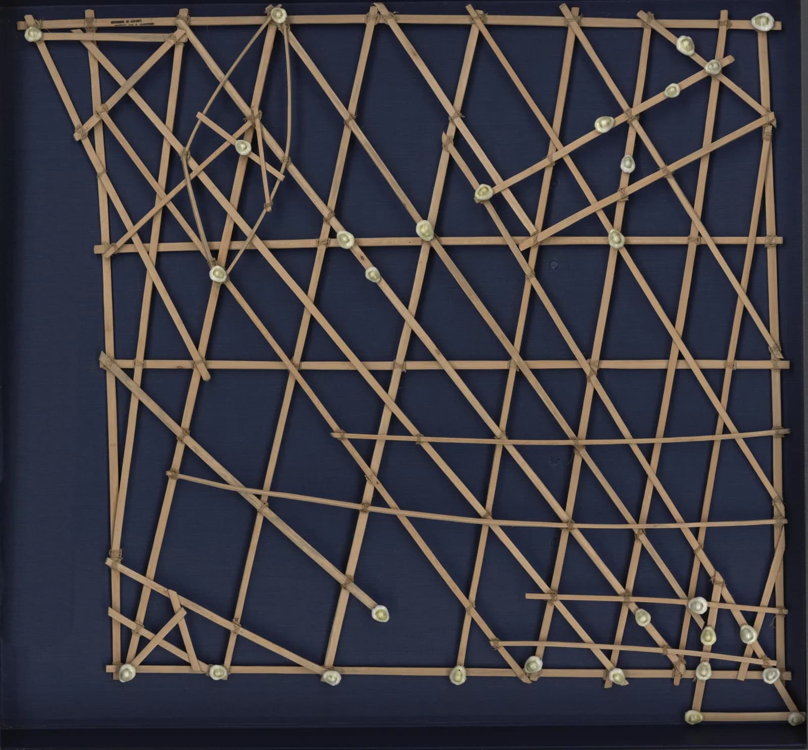
The Library of Congress holds a square of wooden strips and shells that measures 67 by 72 centimeters. Its catalog calls it a stick chart of the Marshall Islands, rebbelib type.
The shells mark atolls and islands. The strips mark currents and ocean swells. The Library's own blog says navigators memorized charts like this one and did not take them on their canoes.
The traditional view
The Marshall Islands lie in two chains. The Library of Congress blog names the western chain Ralik and the eastern chain Ratak. Joseph Genz and colleagues write that navigators may spend several days out of sight of land. The tops of coconut palms on these low atolls can only be seen 20 kilometers offshore.
The blog describes three kinds of stick chart. The mattang was a training chart. The meddo mapped a section of a chain. The rebbelib covered a large area of the Marshall Islands.
The Library's catalog record says the rebbelib in its collection was used by the Marshallese to navigate the Pacific Ocean by canoe. It supplies the date as 192-? and names no maker. The blog says the Library's three charts were made in the 1920s in Majuro.
The charts first came to the attention of Westerners in an 1862 report by an American missionary. Marcia Ascher of Ithaca College writes that about 70 charts and some information about them were obtained over the next 50 years. She spells the word rebbelith. I use the Library's spelling.
Genz and colleagues write that Marshallese navigators use wave patterns for course setting, orientation, estimating progress and remotely sensing land. They describe a system of wave piloting that is distinct from the star-based methods of other Micronesians.
The blog says navigation techniques were passed on from father to son. Ascher adds that the child chosen to carry on the knowledge could be male or female.
Genz lists several reasons that long voyages declined from the late nineteenth century. They include strict protocols of knowledge transmission, social disruption under colonial administrations and the effects of nuclear weapons testing. Between June 2005 and September 2006 Joseph Genz and Alson Kelen of Canoes of the Marshall Islands learned traditional navigation from Captain Korent Joel and other experts. The 2009 paper records the wave concepts they learned.
What the Charts Left to Memory
Two ideas in Earthly Enigmas sit close to this subject.
In Chapter 11 I write that oral tradition is a technology and that the human memory was the medium. In Chapter 5 I argue that building the network of sites took knowledge of latitude and longitude and the skill to navigate the ocean. I also name the 2020 Nature paper on Polynesian and South American contact around 1200 CE, which the Rapa Nui article covers.
The Marshallese sources describe a map that lived in memory and a navigator who found islands without instruments. I set the two side by side here. The book itself does not connect them.
The Chart That Never Went to Sea
The sources leave questions open. Three of them stand out.
Is it a chart?
The Library of Congress catalog says the rebbelib was used by the Marshallese to navigate the Pacific Ocean by canoe. The Metropolitan Museum says stick charts were originally used by navigators during long ocean voyages and calls them functional objects. The Met's example is a different rebbelib, one without shells.
Other sources place the charts on land. The Library's blog says navigators did not take them on their canoes. The Smithsonian Ocean portal says stick charts were not really made of sticks and not really used for navigation. Ascher writes that the rebbelith and meddo were used on land for the transmission and preservation of knowledge. The information on them was carried on a voyage but the objects were not.
Genz and colleagues trace the disagreement to the first reports. Scholars initially read the models as stick charts that showed islands, sailing courses and sea conditions. The authors cite reports from 1862 and 1863. Later studies, they write, showed that the models were "not nautical charts or instruments, but rather teaching devices."
The Jaume Olives portolan chart article asks a related question about ornamental European charts. What do we call a map that never goes to sea?
How did they learn where the atolls sit?
Ascher examined a rebbelith that depicts a region of over 750,000 square kilometers. She calls the relative positions of the atolls "remarkably accurate given that they were determined without technological aids and that vast open ocean spaces are involved."
Later in the same section she writes of the meddo that, as with the rebbelith, "the distances are not accurate nor were they intended to be." The Smithsonian Ocean portal makes both points about the meddo. Island positions relative to one another turned out to be quite accurate. The chart was not to scale.
In their study Captain Korent Joel guided a yacht 220 kilometers between two atolls using traditional navigation techniques. How did navigators learn where the atolls sit in relation to one another when they could spend days out of sight of land?
What is the dilep?
Genz writes that the wave paths on a rebbelib extend "between certain pairs of islands like a path." He adds that this representation resembles the wave models navigators build today. Navigators call a line of waves between islands the dilep, which means backbone. Genz and colleagues write that the navigators' highest art is to keep the canoe on it.
The researchers measured waves with a buoy under the guidance of Captain Joel. They write that the navigators describe the dilep as a wayfaring signal, but "we cannot presently explain its formation." Their oceanographic data supported another sign, a pattern of crossing waves in the lee of an atoll that the navigators call nit in kōt. The data did not account for the dilep.
The authors suggest that the dilep might be a conceptual device rather than an oceanographic phenomenon. They also report that the navigators maintain that following the dilep is distinct from steering by the relative angle of the swells.
The surviving navigators do not fully agree among themselves. In a later paper Genz writes that the greatest divergence among his informants lies in the explanation of the dilep. Some cite reflected wave energy from a dominant incoming swell. Others cite opposing swells.
The Smithsonian Ocean portal says researchers have found that the navigation techniques align quite closely with oceanic phenomena we understand today. The 2009 paper supports one sign and says additional measurements are needed for the others. What is the dilep?
The questions I can't put down
Some questions need more room than one article gives them. Two of them keep pulling me back.
How old is the knowledge the charts hold? Kayanne and colleagues report archaeological evidence of settlement in the Marshall Islands as early as 1,900 years ago. The Smithsonian Ocean portal says the islands have been inhabited for around 3,000 years. The Library's blog says Marshall Islanders used this form of navigation for thousands of years. The first Western report of the charts is from 1862. The oldest object dates I saw are from the nineteenth century, and I have not searched for older ones. In Chapter 11 I write that oral traditions preserved the memory of coastlines and astronomy for thousands of years. I follow that question through Earthly Enigmas.
What did the charts once hold that nobody can now read? Genz reports that navigators around the turn of the twentieth century recalled the names of 66 stars and how to use them to reach specific atolls. His informants remembered only a few. They no longer remember, or never learned, the hidden meanings of the song-stories and chants their teachers performed. Ascher writes that the tellers who spoke to Westerners never intended to give full understanding to others. The Library's blog says Captain Joel, who died in 2017, taught Marshallese youth the navigation he learned from his grandfather. The Chapter 11 section called "Oral Traditions Encoding Lost Knowledge" takes up memory as a way to carry knowledge, though it does not mention the Pacific. You can read a free sample before you decide. The articles section has more subjects in the same format.
Sources
- Library of Congress: Marshall Islands stick chart, Rebbelib type (item 2010586182)
- Library of Congress blog: The Unique Seafaring Charts of the Marshall Islands (2021)
- The Metropolitan Museum of Art: Rebbilib (navigational chart), 1978.412.826
- Smithsonian Ocean: Navigating the Waters with Micronesian Stick Charts
- Genz, Aucan, Merrifield, Finney, Joel and Kelen, Wave Navigation in the Marshall Islands, Oceanography 22(2), 2009
- Genz, Resolving Ambivalence in Marshallese Navigation (eScholarship PDF)
- Ascher, Models and Maps from the Marshall Islands: A Case in Ethnomathematics, Historia Mathematica 22 (1995)
- Kayanne et al., Rapid settlement of Majuro Atoll, central Pacific, following its emergence at 2000 years CalBP, Geophysical Research Letters 38 (2011)