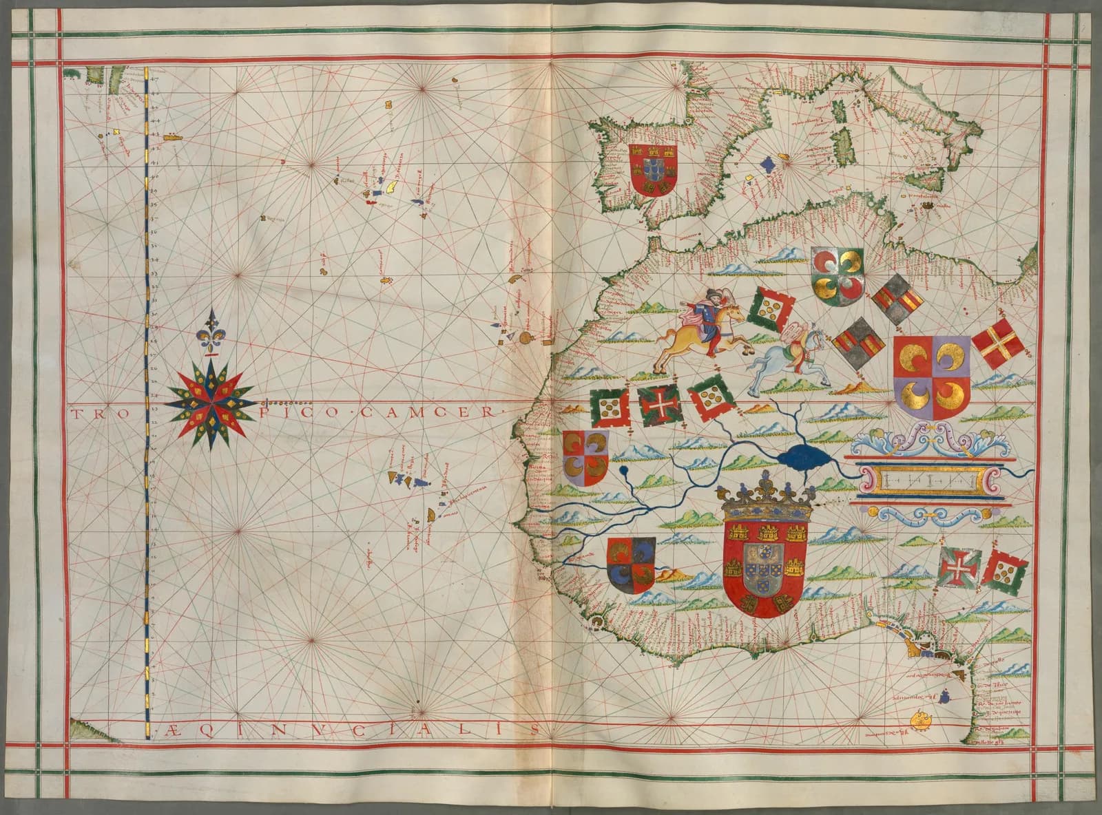
The Bavarian State Library holds a portolan atlas bound in costly red morocco leather with gold ornaments in oriental style. Its leaves of fine white parchment carry charts of the old world and the new.
The library's collection page says Fernão Vaz Dourado drew it in Goa in 1580. Its catalog record says he is thought to have made it.
The traditional view
The Bavarian State Library catalogs the atlas as Cod.icon. 137. The catalog lists 38 parchment leaves and gives the dimensions as 47 by 33.5 centimeters. The record says the atlas extends "from South America to the Persian Empire, to China (where Canton is named), to Java and New Guinea, and to North America."
The same record says Dourado "is thought to have made the atlas in 1580, near the end of his life." It adds that the atlas "was commissioned by the Portuguese crown and produced in Goa, western India, where Dourado spent his last years." The Library of Congress hosts the record in its World Digital Library and repeats the description.
João Carlos Garcia of Porto University writes in a commentary on the 1571 facsimile that Dourado "authored at least four different nautical atlases." The History of Cartography calls his the first maps to "acceptably represent the islands and peninsulas of the Far East." Garcia reads the 1571 atlas as "an apologetic work for the Portuguese overseas expansion."
What the Atlas Was Built From
In Earthly Enigmas I treat the Piri Reis map as a compilation of older source maps that have not been found. I write that someone, before 1513, had mapped the Atlantic coastlines with unusual accuracy. I follow that question in Chapter 5 and again in Chapter 15.
Dourado's atlases belong to the same craft in the same century. Garcia writes that the coasts of the Far East on the 1571 atlas were "based on nautical itineraries." Of the Portuguese maps of Central America and the Antilles the chapter in the History of Cartography says that "the sources of information were indirect."
What Has Not Been Settled
Both views lean on questions the evidence cannot yet answer. Three of them stand out.
How many atlases did he make, and who drew them?
Garcia counts at least four atlases. The History of Cartography lists six, dated "ca. 1568, 1570, 1571, 1575, ca. 1576, and 1580." The Library of Congress says he "is known to have produced seven brilliantly illuminated sea atlases between 1568 and 1580." It says this on the record for a different atlas in Lisbon. It attributes that atlas to him "based on similarities between other maps by Vaz and illustrations in this manuscript."
The man himself is hard to pin down. Moleiro, the publisher of the 1571 facsimile, writes that "little is known for sure about the mapmaker." The same text suggests he had "one prototype atlas and created all his others by making additions or modifications." I have not found where that prototype is.
A page from the European Digital Treasures project is signed by a senior technician of the Portuguese archives directorate. It adds that such works "could have been the product of a slow, complex, segmented and collective effort."
The dates raise a second puzzle. The Huntington Library dates its atlas HM 41 "between 1550 and 1575" and says it was "produced ca. 1570, probably in Goa where the cartographer lived until 1571." The Bavarian library places a Goa atlas in 1580 and says he spent his last years there. I have not found a document that reconciles the two statements.
How many atlases are his, and how many hands drew them?
What was it for?
The Bavarian record says the atlas belongs to a class of masterpieces. It says they reflect "the period's rising demand for cartographic works that were both visually impressive and useful for practical navigation." The History of Cartography gives the Portuguese charts of the Far East and the Indian Ocean "a utilitarian purpose, navigation and commerce." Garcia notes better information on coasts that were "commercially more attractive."
Moleiro reads the atlases another way. It says the 1571 atlas "seems to owe more to the art of illumination than to cartography." The Agnese article sets out the same debate for a Venetian workshop of the same decades.
The Bavarian record says the crown commissioned the 1580 atlas. It cites no document, and I have not seen a commission record.
Was it made to sail by or to be shown?
Was the knowledge guarded or copied?
BiblioAsia, a publication of the National Library Board of Singapore, says the Portuguese monopoly in Southeast Asia "depended on closely guarded knowledge about the best sailing routes." The History of Cartography says a policy of silence "has become a veritable theory" in Portuguese historiography. Its authors answer that "it would be a mistake to consider the absence of documentation as proof of the secrecy theory." They add that the same caution "applies to those on the opposite side of the present argument, who deny the existence of any secrecy."
Dourado's images give a different picture. Moleiro writes that they "were soon found in the printed cartography of northern Europe." It names Linschoten's work and editions of Ortelius's work. BiblioAsia says Linschoten's 1596 map was composed from "the navigational charts of Fernao Vaz Dourado." The History of Cartography says Linschoten lived in Goa from 1583 to 1589. It adds that Portuguese cartography spread "mainly in the Netherlands" while dissemination stayed "very restricted in Portugal." A search excerpt of a 2024 open-access book says Linschoten likely consulted a Dourado atlas from the 1570s. I have not read that chapter.
The Munich atlas took another road. The library says it was transferred from Polling Abbey in Upper Bavaria when the abbey was dissolved in 1803. The record does not say how a crown commission made in Goa reached a Bavarian abbey.
A Dourado atlas in California has two stories. The Huntington Library says a sale catalog traced HM 41 to the library of the Archbishop of Toledo. Cortesão and Teixeira da Mota disagree. They "feel that this atlas was in the Biblioteca Nacional in Madrid until 1866 but disappeared after being taken to the Paris Exhibition in 1867."
Who saw these charts, and how did they travel?
The questions I can't put down
Some questions need more room than one article gives them. Two of them keep pulling me back.
Where did the Pacific coasts come from? The Huntington atlas includes charts of the west coast of North America, of the United States and Mexico, and of South America from Ecuador to northern Chile. The History of Cartography says Dourado drew California in ten maps made between 1568 and 1580. I have not found a source that names the reports behind those charts. I follow the older source maps behind the Piri Reis coastline through Chapter 5 and Chapter 15 of Earthly Enigmas.
Why is there no land to the south? A page from the European Digital Treasures project lists among the missing elements of the 1571 atlas "Australia and some islands north of this continent." History Today introduced a 1988 article by Helen Wallis with this line. "Dieppe map makers placed the Portuguese flag on a large land-mass called Java-la-Grande approximately where Australia appears on today's atlas." I have read only that introduction. Robert J. King quotes the Portuguese historian Oliveira Martins that "Australia was not visited by any Portuguese in the sixteenth century." King is an individual researcher and I have not checked his credentials. Manuel Godinho de Erédia, who worked in Goa and Malacca, was passionate about a southern continent "which he guessed existed south of Indonesia." In Chapter 15 of the book I look at the Piri Reis coastline and at what lies under the Antarctic ice. The Piri Reis map article follows the other half of that debate. You can read a free sample of the book before you decide. The articles section has more subjects in the same format.
Sources
- Bayerische Staatsbibliothek: Portulanatlas (Alte Welt und Terra Nova), Cod.icon. 137
- Bayerische Staatsbibliothek: Hand-drawn maps
- Library of Congress: Atlas with Portolan Charts of the Old World and New World, 1580
- Library of Congress: Atlas attributed to Dourado, about 1576 (National Library of Portugal)
- Huntington Library: Portolan atlas, Portuguese, HM 41
- Alegria, Daveau, Garcia and Relaño, Portuguese Cartography in the Renaissance, History of Cartography vol. 3 (University of Chicago Press, 2007), chapter 38 (I read the passages that name Dourado and the policy of silence section, not all 94 pages)
- João Carlos Garcia, excerpt from the commentary volume of the Universal Atlas of Fernão Vaz Dourado (medievalists.net) (an excerpt, not the full volume)
- M. Moleiro Editor: Universal Atlas of Fernão Vaz Dourado (publisher text, commercial)
- European Digital Treasures: Atlas of Fernão Vaz Dourado, 1571
- BiblioAsia: The Map That Opened Up Southeast Asia (National Library Board, Singapore)
- Helen Wallis, Did the Portuguese Discover Australia? (History Today, 1988) (paywalled, standfirst only)
- Robert J. King, Jave la Grande, a Part of Terra Australis? (ANZMaps) (talk text, seen through a search excerpt, credentials not checked)
- Knowledge Exchanges between Portugal and Europe, chapter 5 on Linschoten (Amsterdam University Press, 2024) (search excerpt only, not read)
- Wikipedia (Fernão Vaz Dourado; Theory of the Portuguese discovery of Australia) was opened only to locate sources. No claim here rests on it.