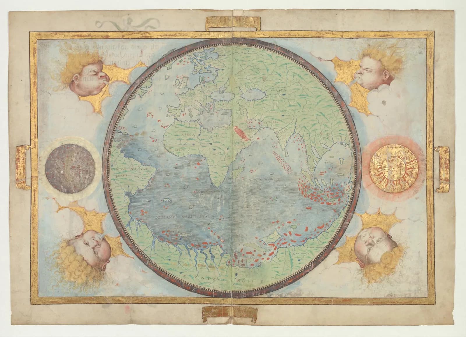
Six loose sheets of vellum, painted on both sides, sit in the Bibliothèque nationale de France. Together they show the world as a Lisbon workshop drew it in 1519.
Lopo Homem put his name and the year on the title page. The sheets that should show Africa are gone.
The specialists I read give different answers on who the atlas was made for.
The traditional view
The Library of Congress hosts the atlas in its World Digital Library records. It says the atlas was produced for King Manuel I of Portugal in 1519. The makers were the cartographers Pedro Reinel, his son Jorge Reinel and Lopo Homem, with the miniaturist António de Holanda. The record says the atlas "contains eight maps on six loose sheets, painted on both sides."
The same record gives the title-page inscription in English. Homem calls it "the map of the entire world known up to this day." He says he drew it in Lisbon in 1519 "having collated many other maps both ancient and recent."
The atlas takes its name from Emmanuel Miller. The Library says he bought it in 1855 from a bookseller in Santarém and that his widow sold it to the French national library in 1897.
A 2026 post on the Gallica blog from the BnF adds more. I translate from the French here. The post calls the atlas a set of six separate vellum sheets that were once bound together. It says the atlas was probably meant for Manuel I. It says Catherine de' Medici had her arms added after 1559. It says the atlas is still incomplete because the maps of Africa have not survived.
The post says Homem had held the title of master of navigation charts since 1517 and that Pedro and Jorge Reinel probably helped him. Joaquim Alves Gaspar led the MEDEA-CHART project on early nautical charts. In an abstract on Academia he writes that most historians attribute the nautical charts to the Reinels, while the world map is signed by Homem.
Gallica describes a dense picture of the Indian Ocean. It names the oldest nautical chart of Madagascar and the first appearance of the Moluccas spice islands in Western mapping. It also calls the atlas a political work that shows the Portuguese empire at its height. The CNRS video page says the atlas "was intended to show the power and expanse of the Portuguese Empire."
The Brazil sheet carries a text on the people of the coast. Gallica prints it as the first impressions Europeans recorded of them. The words are hostile and they come from outsiders.
An earlier Portuguese world chart is the subject of the Caverio planisphere article.
The Maps Homem Collated
In Earthly Enigmas I treat the Piri Reis map as a compilation of older source maps that have not been found. I follow that question in Chapter 5 and again in Chapter 15.
The Miller Atlas names its own method. Homem says on the title page that he collated many other maps. The Library of Congress record does not say which ones.
Wikipedia reports an argument by Robert J. King in The Globe in 2022. It says the layout of the world map was apparently drawn from a description Duarte Pacheco Pereira set out in 1508, with a map of his that is now lost. The same article lists the 1513 Piri Reis map among world maps of this type. I have not read King's paper, so I have not checked either statement.
What Nobody Has Settled
Each reading of the atlas leans on questions the evidence cannot yet answer. Three of them stand out.
Who was it for?
The Library of Congress says it was produced for King Manuel I. Gallica says it was probably meant for him.
Alfredo Pinheiro Marques of the University of Coimbra reads it differently. He wrote essays for the commentary volume of a facsimile of the atlas, and his essay is on the publisher's site. In an essay on Moleiro's site he writes that the king ordered it but that it was "intended for the young Flemish princess Leonor." She had become queen on marrying Manuel I the year before. Pinheiro Marques adds that the unfinished state of the atlas shows Manuel "never intended it to be sent as a state gift." In his opinion Leonor took the unfinished atlas with her when she left Portugal in 1523.
Alves Gaspar writes in his abstract that the atlas is so opulent that it suggests "a gift to some royal house." He does not say which one.
Wikipedia says the atlas "is thought to have been an offering" from Manuel I to Francis I of France. It gives no source for that statement in the article. I have not checked it.
I found no source that explains how the atlas passed from Lisbon to Catherine de' Medici, or from there to a bookseller in Santarém.
Who was meant to open it?
Was the world map a message?
Pinheiro Marques calls the atlas "a deliberate geographical deception." He describes the opening world map as one that joins all the seas into "a kind of great lake" and enlarges the land. In his reading the Portuguese crown meant to persuade the Castilians that a western route to Asia was impossible. He ties this to Magellan's voyage, which was being prepared in Seville in 1519.
He writes that the debate over the map "was finally resolved in 2005–2006" with his research. He adds that ideas once thought novel "have, in the intervening years, become universally accepted."
Other sources describe the same map in other terms. The Library of Congress says it shows the Portuguese hemisphere and "only the territory allocated to Portugal." Wikipedia says the world map has raised "great controversy among scholars." It cites William Randles (1994) for the reading that the map aimed to dissuade Magellan. It reports that King sees a stage in the history of Ptolemy's enclosed ocean. I have not read either. Alves Gaspar calls the content an anachronism and his abstract names no cause.
In the Gallica post I read, the atlas is political and shows the empire at its height. The post does not mention a deception.
Pinheiro Marques dates the whole atlas from 1519 to about 1522. Alves Gaspar dates it from about 1517 to 1519 in the title of his piece. Homem's own inscription says 1519.
Was the opening map a message to Castile, or an old picture of the world drawn again?
What is missing?
Gallica says the maps of Africa have not survived. The CNRS page says the Africa map "went missing." The sea route to India that made Portugal rich ran around Africa, as Gallica itself notes.
Pinheiro Marques points to a second gap. He writes that the pages that should have shown the far side of the world, between the Far East and Brazil, were left incomplete. One has only the lines of a wind rose and the other is blank. He says the atlas was taken apart at an unknown date.
The Library of Congress records another blank. On the Atlantic sheet it says "the right half folio is blank."
The counts differ as well. The Library of Congress says eight maps on six sheets. Alves Gaspar writes of ten nautical charts and a world map. Pinheiro Marques lists five sheets of one size and a larger sheet made of two parchments stuck together.
What did the complete atlas hold, and who took it apart?
The questions I can't put down
Some questions need more room than one article gives them. Two of them keep pulling me back.
Where are the maps Homem says he collated? His inscription points to older sources, and the sources I read name only one candidate, a lost map by Pacheco Pereira, secondhand. In the book I follow the same question to the Piri Reis map, which says outright that it was drawn from older charts. You can find that thread in Earthly Enigmas, and the Piri Reis article sets out the debate over its sources.
What is the land at the bottom? The world map wraps a vast southern land around the southern ocean. Pinheiro Marques calls it "a huge and fantastical southern land-mass" and Wikipedia, citing King, calls it the austral terra incognita. In Chapter 15 I take up the southern coast of the Piri Reis map. You can read a free sample of the book before you decide. The Agnese atlas article looks at a later oval world map that traces Magellan's route. The articles section has more subjects in the same format.
Sources
- Library of Congress, Miller Atlas, folio 1 (World Digital Library record, BnF original)
- Library of Congress, Miller Atlas, folio 2 (World Digital Library record, BnF original)
- Gallica blog, L'Atlas Miller : le monde avant Magellan (BnF, 2026)
- CNRS Images, Nautical Atlas of the World, aka Atlas Miller (CNRS and BnF)
- Alfredo Pinheiro Marques, The Atlas Miller: A Trojan horse against Magellan's project (Moleiro Editor)
- Alfredo Pinheiro Marques, Secrets of the Atlas Miller (Medievalists.net, 2019)
- Joaquim Alves Gaspar, Chart of the Week: Miller atlas (c. 1517-19) (abstract on Academia)
- Wikipedia, Miller Atlas (used to locate King and Randles; I have read neither)