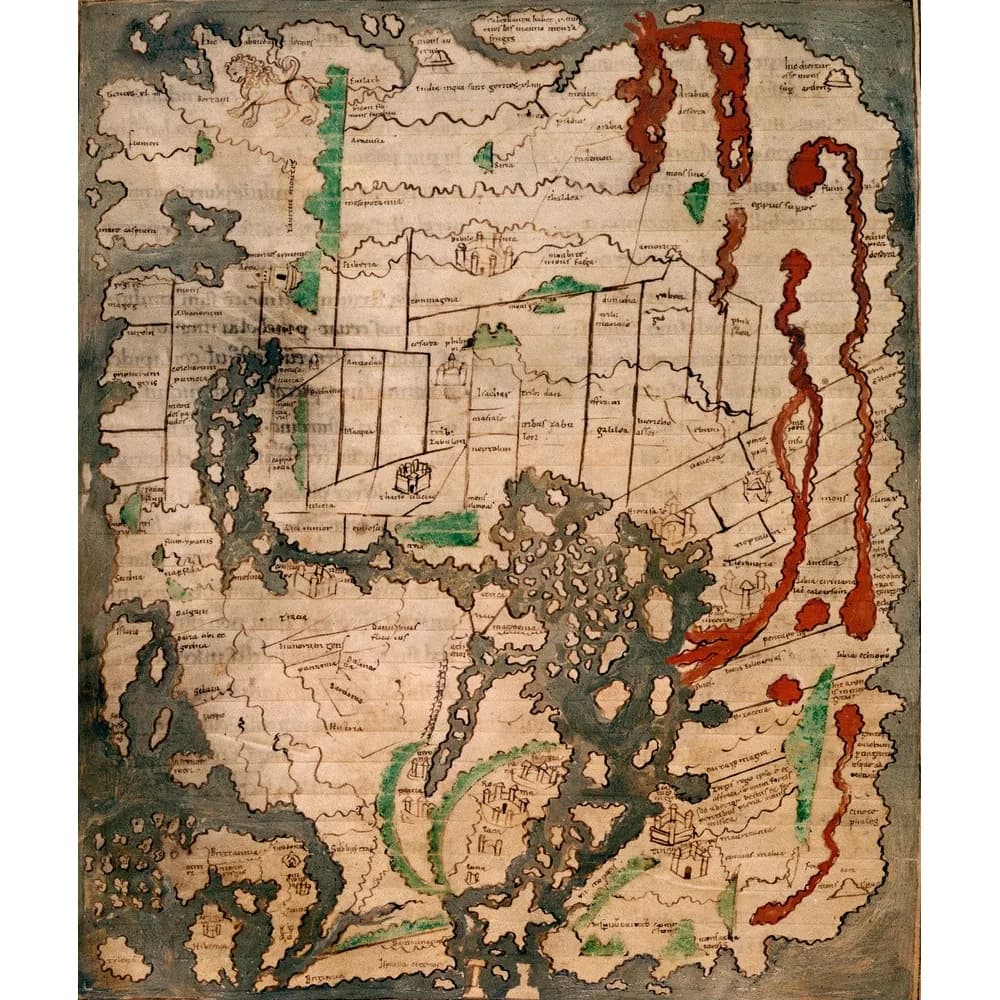
The map fills one full page of a book copied in the first half of the eleventh century. East is at the top and Britain sits in the north-western corner.
Two specialists who have studied it closely agree that it copies something older. They do not agree on how much older, or on whose view of the world it shows.
The traditional view
The British Library catalogs the map as folio 56v of Cotton MS Tiberius B V/1. The record describes a collection of computistical, geographical, historical and astronomical texts. Computistical means concerned with calculating the calendar. It says one scribe copied most of the manuscript in the second quarter of the eleventh century, possibly at Canterbury.
Helen Appleton calls it the only surviving mappa mundi from Anglo-Saxon England. In her article she writes that the map presents a detailed image of the inhabited world, centered on the Mediterranean. Alfred Hiatt, in a 2022 chapter, calls it one of the best-known and most widely reproduced medieval world maps. He adds that attention to it has tended to be passing and that many questions remain.
Hiatt describes the picture. Asia, Europe and Africa sit inside a surrounding ocean. The Red Sea and the Nile are red and the mountain ranges are green. The Holy Land is dominated by the twelve tribes of Israel, and Britain appears large.
He says the map's principal source is the opening description of the world in Orosius, a work from the early fifth century. Orosius gives two theories about the source of the Nile. The map draws both.
The catalog says leaves of the volume were damaged by fire in 1731. It also says a letter of introduction is required to view the manuscript and lists the digital images as currently unavailable. That page is an interim version while the library recovers from a cyber-attack.
Hiatt compares the map with the earlier Albi map and a Vatican map. He says all three derive from earlier models. The Albi article covers that map.
A Copy Of Something Larger
Both scholars read the Cotton map as a copy of something that no longer survives. They place the original in different centuries and give it different purposes. The questions below follow those differences.
In Earthly Enigmas I write that someone, before 1513, had mapped the Atlantic coastlines with unusual accuracy from older source maps. Those source maps have not been found. The Piri Reis article sets out that case. In Chapter 11 I list the burning of the Library of Alexandria with the other destruction of knowledge.
What The Specialists Cannot Settle
Both views lean on questions the evidence cannot yet answer. Three of them stand out.
What was it copied from?
Evelyn Edson, quoted by Appleton, thinks the scribes felt a map would suit the book and "simply copied one they had at hand." Edson also observes that unlabeled features suggest a larger wall map as the source. Peter Barber has suggested that the larger map may have been at Glastonbury.
Appleton adds that large wall maps are far less likely to survive than small maps bound into books. Many are known only from descriptions. She reasons that the lack of survivors does not show that such maps never existed.
Her own reading puts the lost original in "the assertive England of the earlier tenth century." She sees Carolingian models behind it.
Hiatt writes that the map was highly unlikely to have been compiled for the first time in the eleventh century. He says its frame "may be as old as Orosius or his own exemplar," or could have been built on Orosius later. He is unconvinced that the map can be tied to specific ancient authors. He still finds it highly likely that it keeps formal elements descended from late antique originals.
He also finds layers. The Holy Land seems to come from a different map, a diagram of the twelve tribes that illustrates a commentary on the Book of Joshua. In his word a compiler welded it to the world image at some point in its transmission.
Who drew the larger map, and what became of it?
Where did the detail in the north come from?
Appleton says the map is unusually accurate about the shape and peoples of north-western Europe. She calls its depiction of the British Isles "exceptionally exact." Citing P. D. A. Harvey, she writes that no better representation appears until Matthew Paris in the thirteenth century.
She also reports significant copying errors in Asia and Africa. Hiatt notes that Gaul carries no name and that many islands are unnamed. Some features suggest to him that the map is incomplete or even unfinished. Appleton says Winchester and Kent are shown, "albeit in the wrong place."
Appleton thinks sources other than late antique maps must have been used. She considers it probable that the north-western section was drafted in part from seafarers' accounts such as the voyages of Ohthere and Wulfstan in the Old English Orosius.
Hiatt reads it differently. His 2020 article, which I have seen only in abstract, argues against the notion that the map shows a characteristically Anglo-Saxon view of the world. He sees an English adaptation of an image current across the Latin West. He says the north and north-west reflect an interest in the spread of Christianity. In the 2022 chapter he calls the shape of Britain only tentatively linked with Ptolemy and says London, Winchester and Armagh are later additions.
Where did the detail in the north come from?
What sits at the western edge?
Appleton says the label Tylen, meaning Thule, sits in the far north-west where a modern viewer would expect Iceland. A large island near Scandinavia is marked Island, close to the Old Norse name for Iceland. She reads this as a mapmaker who knew of a place called Island but was unsure where it lay. She notes that the Ælfric text in the same manuscript still speaks of Thule.
She writes that the Pillars of Hercules are the only thing on the absolute western margin. Beyond them lies the unknown, which she says is "beyond the scope of this map."
Patrick Shekleton describes the western margin differently. His Academia presentation of 109 slides argues that structure icons along that margin mark places in the Labrador, Newfoundland, Cape Cod and North Florida regions. He writes that the North American seaboard "had been surveyed in the 11th century." He groups the labels Trabrobanen and Tylen with the icons. I have read only his abstract and have not seen his slides.
The abstract also says scholars cite Cambridge as the place of production. The catalog and both scholars I read name Canterbury, and Hiatt adds Winchester. I have not checked where the Cambridge claim comes from.
The two descriptions of the margin cannot both fit the folio. What would settle which one does?
The questions I can't put down
Some questions need more room than one article gives them. Two of them keep pulling me back.
Was the map ever meant to sit beside the Periegesis? It now faces the opening of Priscian's Latin version of a Greek geographical description of the world. The heading of that text says a suitable map was drawn for it. Appleton writes that the map was originally bound immediately before that text. Hiatt writes that it first stood at the very end of the manuscript and reached its place through post-medieval rebinding. Both say its content does not follow the text closely. In the book I follow the Chinon Parchment, a document miscataloged for centuries, and I ask what else sits in the archives. I follow that question through Earthly Enigmas.
How old is the picture? The catalog dates the manuscript to the second quarter of the eleventh century. Appleton places the lost original in the earlier tenth. Hiatt allows a frame as old as Orosius. A compiled monograph on the My Old Maps site dates the map to about 995, and I have not checked its basis. In the book I write about annotations on the Piri Reis chart that cite sources from the age of Alexander the Great. You can read a free sample before you decide. The articles section has more subjects in the same format.
Sources
- British Library, Cotton MS Tiberius B V/1, ff. 2-73, 77-88 (catalog record)
- British Library, Cotton MS Tiberius B V (catalog record, condition and access)
- Appleton, The northern world of the Anglo-Saxon mappa mundi, Anglo-Saxon England 47 (2018) (abstract on the publisher's page; full text read in the Oxford Research Archive copy)
- Hiatt, The Cotton Mappa mundi as analogue to the Albi world map, in La Mappa mundi d'Albi (Éditions de la Sorbonne, 2022)
- Hiatt, An Anglo-Saxon World View? The Cotton mappa mundi Reassessed, Viator 51 (2020) (abstract only)
- Shekleton, c. 1025-1050 Cotton World Map (Rev. B): Evidence of North America Survey Mapping (Academia) (abstract only)
- My Old Maps, The Cottoniana or Anglo-Saxon Map, monograph #210 (compiled secondary source)