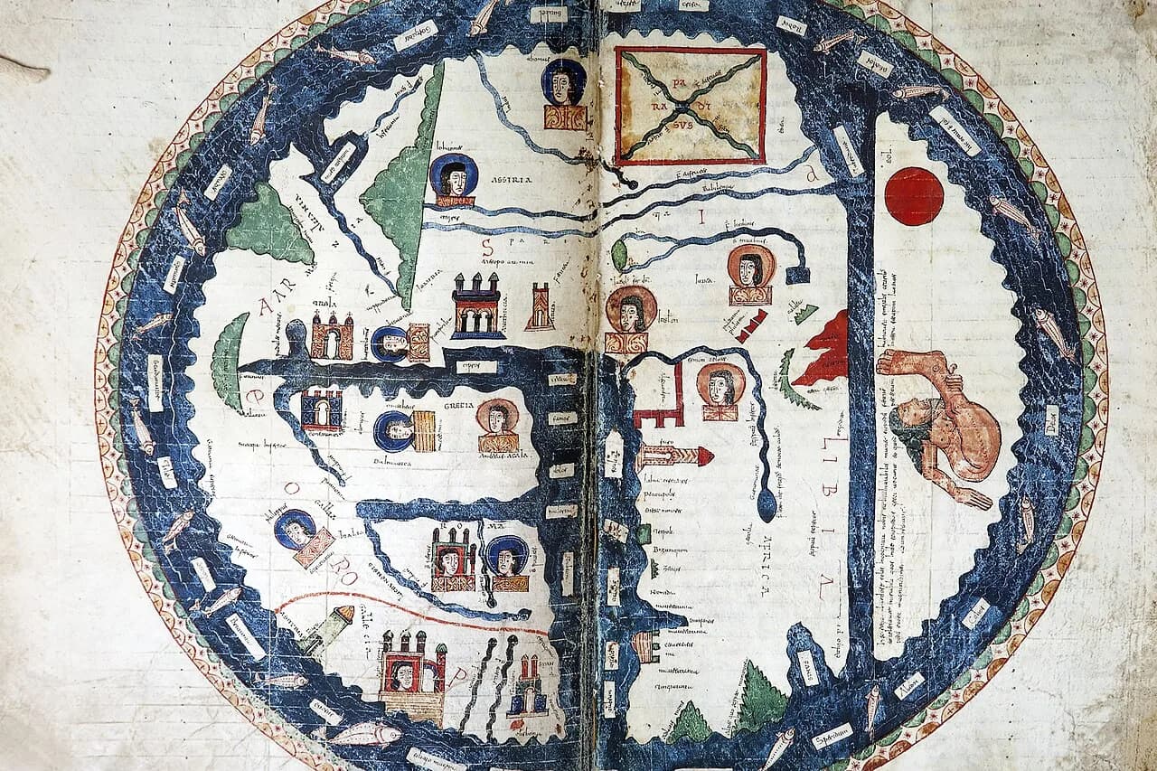
Early in a book kept in the cathedral archive at El Burgo de Osma in Spain, a map of the world spreads across two facing pages. East is at the top with Paradise. Far in the south a figure lies on his back with one huge foot raised.
The book is dated 1086. The map in it copies one drawn about three centuries earlier, and that one is lost.
The traditional view
Beatus was a monk in the Liébana valley of northern Spain. The Diocese of Osma-Soria says he finished his Commentary on the Apocalypse of Saint John around the year 786. Copies of the Commentary were made for centuries, and many of them carry a world map.
David Woodward counts fourteen large maps in the surviving copies in his chapter on medieval world maps. He says they can be traced back to a lost prototype of 776 to 786. He writes that maps of this kind were made "to instruct the faithful about the significant events in Christian history rather than to record their precise locations."
The Osma copy was begun in 1086. Scriptorium quotes Peter Klein saying it was written by the presbyter Pedro and illuminated by the painter Martino. He says the codex came from the monastery of Saint Facundus and Saint Primitivus in Sahagún. The Diocese says it has 166 folios and that 71 of them carry illustrations.
Museo Galileo describes the map as showing the diaspora of the apostles after Pentecost. The University of Seville's facsimile catalog says the painter set the head of each apostle in the region he was given. Susanna Tavera calls it the most interesting of all the Beatus maps, in her essay on the Osma map.
What the Evidence Does Not Settle
The Beatus maps appear nowhere in the book. Chapter 5 takes up a different map built from older sources. I write that someone before 1513 had mapped the Atlantic coastlines with unusual accuracy, and I read the Piri Reis map as drawn from older source maps. The Piri Reis article sets out that map.
The Map Nobody Has Seen
The scholars who study the Beatus maps agree on the date of the codex. They disagree on much else. Three questions stand out.
Who lives in the south?
The large Beatus maps add a fourth part of the world to the three that Europe knew. It sits in the south beyond an ocean.
Woodward gives the legend the maps carry on it. The fourth part is "the farthest from the world, beyond the ocean, which is unknown to us on account of the heat of the sun." The legend adds that "the Antipodeans, around whom revolve many fables, live within its confines." Woodward writes that Beatus considered the fourth continent to be inhabited and that the apostles were to go there.
Tavera reads the Osma map differently. She writes that the apostles evangelized the different parts of the world "but not the fourth part." She calls that section a terra incognita.
The Henry Davis Consulting monograph on the Beatus maps gives a third reading in a passage that begins with the historian John Williams. It says this part is "not an anti-ecumenical hemisphere but the southernmost zone of the inhabited world." I have not read Williams's article and cannot say the reading is his.
The Osma painter made his own choice. The University of Seville's catalog says the map replaces the Antipodeans with sciapods. A sciapod is a man with one leg who shades himself with his huge foot, as Isidore of Seville describes him in the monograph's translation. The southern land holds one, lying on his back.
Augustine is one of the authorities Beatus names in his preface. In City of God he calls the fable of the Antipodes "on no ground credible." About races such as the sciapods he writes that if they are human "they are descended from Adam."
Who did the mapmaker think lived in the south?
How much of the map did Beatus draw?
The earliest surviving Beatus maps date from the tenth century. The Osma map was painted in 1086. Every one of them copies a prototype that Woodward calls lost.
The Davis monograph reports that the scholars disagree on which copy comes closest. Konrad Miller took the Osma map as the best record. It has 120 place names against 96 on the earlier Escalada map. Wilhelm Neuss preferred the Saint-Sever map. Peter Klein, Anne de Egry and Serafín Moralejo proposed the Lorvão map.
The monograph's own view favors Escalada. It says Martinus revised the old imagery "more than any other painter of his time" and that the Osma map "may be the result of a radical reworking." It names three details as likely updates. The apostles' busts may be "a sign of updating." The shrine of Santiago stands on a site that "developed only in the course of the ninth century." It adds that "it is difficult to imagine that a sciopod was designed much before that of the El Burgo de Osma map."
The University of Seville's catalog points to a fortress for Toledo, which had been conquered only a year earlier. It also points to a basilica for Santiago drawn almost twice as long and tall as the one for Saint Peter. It reads both as signs of the moment the map was made.
In the facsimile publisher's commentary Klein says the Osma codex "reflects the best of the original version of the Beatus." He cites the map with its apostles' busts as an example. The monograph reports that Klein also judged the Lorvão map closer to the original because it lacks the added material found on the Osma map. I have not read Klein's own text. The monograph itself says an inquiry on the archetype is "to be treated with caution."
What did the first map look like?
Who made this copy, and when?
The University of Seville's catalog says the colophon on folio 138 verso names Petrus the cleric as the scribe. It says the handwriting shows that several people worked on the text. The painter Martinus signs under the omega on folio 163.
The same catalog says researchers disagreed on where the book was made. They named the monastery of Carracedo, Osma itself or a place in central Castile. It says the format, script and decoration now point beyond dispute to Sahagún. I translate that from "incontrovertiblemente." Klein and the Diocese also name Sahagún.
The year is on the book. Klein writes that the work was begun in 1086 "probably on January 3rd." The Spanish Wikipedia article says it was finished on 3 June 1086. I have not seen the colophon and I cannot say which day is right.
The map literature once got the year wrong. The Davis monograph says Miller assigned the codex to 1203 although a note in the manuscript dates it to 1086. It says the mistake "persisted in the cartographic literature for an astonishingly long time." Tavera writes that the manuscript was not properly rediscovered until 1929 and that a complete facsimile did not appear until 1992.
Woodward wrote in 1987 that physical analysis of parchment, pigment and ink would give "some much-needed benchmarks in dating and locating the place of manufacture" of key artifacts. He meant medieval world maps in general. I have not checked whether anyone has done it for the Osma pages.
What would settle who made the book and when?
The questions I can't put down
Some questions need more room than one article gives them. Two of them keep pulling me back.
Where is the older map? The sources offer several possibilities behind the lost prototype. The Davis monograph reports Miller's view of a fourth-century Roman world map, which he called self-evident. It reports Williams's view that Tyconius's Commentary is a probable source for the map and that a map based on Orosius is another possible model. Gonzalo Menéndez Pidal moved the model to an Isidorian map. In the book I follow the Piri Reis map, which names older source maps of its own. I follow what a lost source map means for global knowledge in Earthly Enigmas.
Why draw a southern land nobody had visited? The Davis monograph says Isidore allowed that the Antipodes probably existed. On a sentence or two of his text, every Beatus copy but one shows an unknown continent south of Africa and the Indian Ocean. I have not seen a source that says anyone had been there. The Piri Reis article covers another southern land from a later century. In the book I follow the Antarctic question in the chapter on what lies under the ice. You can read a free sample before you decide. The articles section has more subjects in the same format, including the Saint-Sever Beatus and the Albi Mappa Mundi.
Sources
- David Woodward, Medieval Mappaemundi, The History of Cartography vol. 1, chapter 18 (University of Chicago Press, 1987)
- Susanna Tavera, The Osma Beatus Map, in World and Global History (Pisa, 2011)
- Diocese of Osma-Soria: El Beato de El Burgo de Osma
- Scriptorium: The Osma Beatus, Prof. Peter K. Klein (the facsimile publisher)
- Universidad de Sevilla, Expobus: Beato de Osma (Spanish; translations are mine)
- Museo Galileo: 1086 Beatus de Liébana
- Henry Davis Consulting, The Beatus Maps, monograph #207 (a compiled secondary text; the scholars it names are cited as it reports them)
- Augustine, City of God, Book XVI
- John Williams, Isidore, Orosius and the Beatus Map, Imago Mundi 49 (1997) (paywalled; abstract only)
- Wikipedia (Spanish): Beato de Osma (secondary, for the June date only)