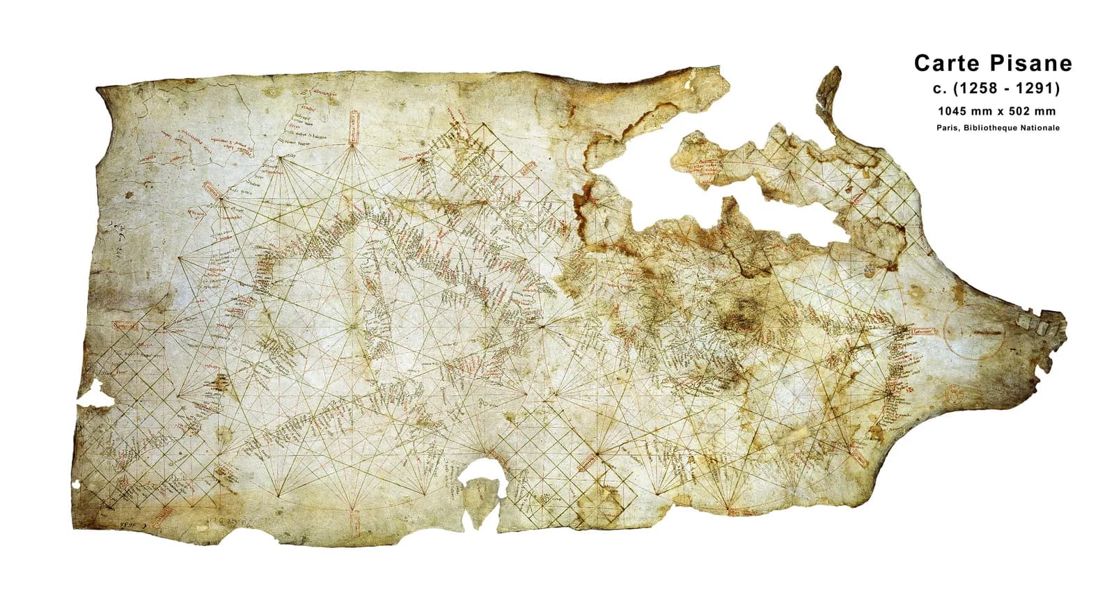
A single skin of vellum, 48 by 103 centimeters, holds the coasts of the Mediterranean and part of the Black Sea. It has no title, no signature and no date.
The catalogue of the Bibliothèque nationale de France writes the place as [Gênes?] and the year as [ca 1270]. Both are in square brackets.
The traditional view
The chart is known as the Carte Pisane because of where it was found. Ramon Pujades writes that its name is derived solely from "the fact that it was supposedly purchased from an old Pisan family." The BnF catalogue says a Chevalier Micali found it in Pisa and that Jomard bought it for the library in 1839.
The BnF's own video text calls it the oldest sea chart to have come down to us. I translate from the French here. It dates the chart to the end of the thirteenth century. It says the Spanish and French coasts and the large islands are drawn "with relative fidelity." It lists the hallmarks of a portolan chart as port names written at right angles to the coast, wind lines that give compass directions and distance scales.
The catalogue adds that two systems of compass lines run inside two tangent circles and that the sheet has no decoration except a red cross near Acre. It also says the place names are unreadable in spots because of holes and stains.
Specialists mostly accept the chart as the earliest of its kind. Tony Campbell, who wrote the chapter on portolan charts in The History of Cartography, concludes that it "should continue to be considered as the oldest surviving portolan chart." Joaquim Alves Gaspar, who led a European research project on early charts, writes that charts like this one were made by artisans "on the basis of navigational data collected by pilots."
What the Chart Does Not Tell Us
Chapter 5 of Earthly Enigmas makes an argument about maps. I treat the Piri Reis map as one correlation among several in my case for a global network. I read it as a compilation of older source maps. I write that someone, before 1513, had mapped the Atlantic coastlines with unusual accuracy.
The Carte Pisane is the oldest sea chart that survives and it also shows Atlantic coasts. Whether it belongs in that argument is not something the book says.
Where the Experts Part Ways
Both views lean on questions the evidence cannot yet answer. Three of them stand out.
When was it drawn?
A French laboratory tested a sample of the vellum. The C2RMF report gives a radiocarbon age of 810 plus or minus 30 years before present. Calibrated at 95.4 percent confidence, that is 1169 to 1270 AD.
The report says a second sample was set aside because the lining material could not be fully removed from the parchment. That leaves one sample.
Campbell points out that "the test was of the vellum and not of the map placed on it." He adds that analysis of the inks "neither directly confirmed the Carbon-14 findings, nor conflicted with them."
Place names add a second clock. Pujades points to Palamós on the Catalan coast, a royal port founded in 1279. Campbell answers that two decrees from 1277 already mention an occupied town of that name.
Pujades takes the argument further. In 2013 he wrote that if the chart had been found today instead of more than 170 years ago, it "would hardly have been dated to the end of the 13th century." Campbell reports that Pujades has since proposed a range of 1280 to 1313. I have not read that book.
Evangelos Livieratos and Chrysoula Boutoura compared the coastline with the modern one. They say the result points to the early end of the radiocarbon range, "or even before."
The BnF itself gives several answers. Its video is titled 1290. Its catalogue says ca 1270 in brackets and notes that the usual dating runs from ca 1275 to ca 1300. The C2RMF site says before 1300.
Which date are we asking about, the vellum or the drawing?
Does a rough chart mean an early chart?
Pujades writes that he and other scholars "exaggerated the antiquity of the chart by identifying a rudimentary nature with primitivism." Campbell reads the same roughness the other way. He sees the Atlantic coasts on the Carte Pisane as the start of a climb, and he writes that "starting with vague oral accounts" the coastlines gradually emerged.
Tome Marelić has a third point of view. He writes in an open-access paper that portolan charts "emerged" in the late thirteenth century "in their almost fully developed form and without any cartographic predecessors known to exist." He also finds that their geometry was "not improved chronologically" and that the accuracy of Pietro Vesconte's charts of 1311 and 1313 "was never surpassed."
Campbell and Marelić measure different things. Campbell reads the Atlantic outlines. Marelić reads the geometry of charts from 1311 to 1538.
Does the Carte Pisane show the start of a tradition or the middle of one?
Who gave the mapmaker his coastlines?
Gaspar writes that early perplexity about how the charts emerged "has given way to a broad consensus about some central questions." In the same abstract he says artisans made the charts from data that pilots collected. Campbell supports that view. He writes that the Carte Pisane and two related charts supply "a partly-oral pre-history" to the steady development seen in the charts of the Vesconte family.
Roel Nicolai of Utrecht University does not agree. In a peer-reviewed article he writes that "majority opinion still holds that portolan charts are medieval creations." He then says there is a "complete absence of historical evidence that supports a medieval origin." He reports that cartometric analysis shows the charts to be composites of accurate regional charts. He says the correspondence with the Mercator projection and the accuracy are "incompatible with a medieval origin."
Marelić says it is "highly unlikely" that portolan charts are genuine late medieval products. He writes that late medieval Italian cartographers could in theory have produced the typical portolan geometry. They would have needed a collection of maps or charts from before the Middle Ages to combine. He adds that this idea should be examined in more detail in future research.
Gaspar answers in a footnote to his own paper. He asks why the "hypothetical older civilization postulated by Nicolai" would have chosen the Mercator projection for small regions of the Mediterranean, "even assuming" it had the means to map them.
One document is read both ways. In 1282 the Persian scholar Qutb al-Din al-Shirazi described a "Greek" map of the Mediterranean. Fateme Savadi and Campbell conclude that it must have been an Italian portolan chart. I read that on Campbell's site and not in the journal. The abstract of Marelić's Cartographica paper quotes al-Shirazi as describing "a map of the Mediterranean that was drawn by the sages of Greece and the ancient geometers." It reports that the coasts of al-Shirazi's schematic fit the Carte Pisane and the Cortona chart well.
What would count as evidence for either source?
The questions I can't put down
Some questions need more room than one article gives them. Two of them keep pulling me back.
What lies behind the oldest chart we have, and what lies behind the Piri Reis map? In the book I read the Piri Reis map as a compilation of older source maps. The Carte Pisane puts the same kind of question in a different century, and the specialists above answer it in opposite ways. I follow the source map question through Earthly Enigmas. The Piri Reis map article sets out that side in detail.
Who drew it, and what is missing? The BnF puts Genoa with a question mark. Campbell says the script is often called Genoese and has also been called Venetian. He also shows from an 1883 photograph that vellum was later removed from the Black Sea area and replaced with a blank piece, "with a significant loss of cartographic detail." You can read a free sample of the book before you decide. The articles section has more maps in the same format.
Sources
- BnF catalogue record, Ge B 1118 RES
- BnF video text, La carte Pisane (1290)
- C2RMF and BnF study site, Carte Pisane and its radiocarbon report by Pascale Richardin (13 April 2016)
- Hofmann, Buisson and Richardin, Is the Carta Pisana still the oldest known marine chart? (Lisbon workshop, 2016) (record only, full text not available)
- Tony Campbell, A detailed reassessment of the Carte Pisane (maphistory.info)
- Ramon Pujades, The Pisana Chart: Really a Primitive Portolan Chart Made in the 13th Century? (2013)
- Livieratos and Boutoura, Carte Pisane and its coastline shape (e-Perimetron, 2018)
- Marelić, Copying-lineages of portolan chart metrics and implications of their pre-medieval origin (International Journal of Cartography, 2024)
- Marelić, Are Portolan Charts and Portolan Mile Geometrically Rooted in Classical Antiquity? (Cartographica, 2024) (abstract only, paywalled)
- Nicolai, The origin problem of nautical cartography (International Journal of Cartography, 2025) (abstract only)
- Gaspar, The origin of nautical cartography: certitudes, doubts, and perplexities (International Journal of Cartography, 2023) (abstract and notes only)