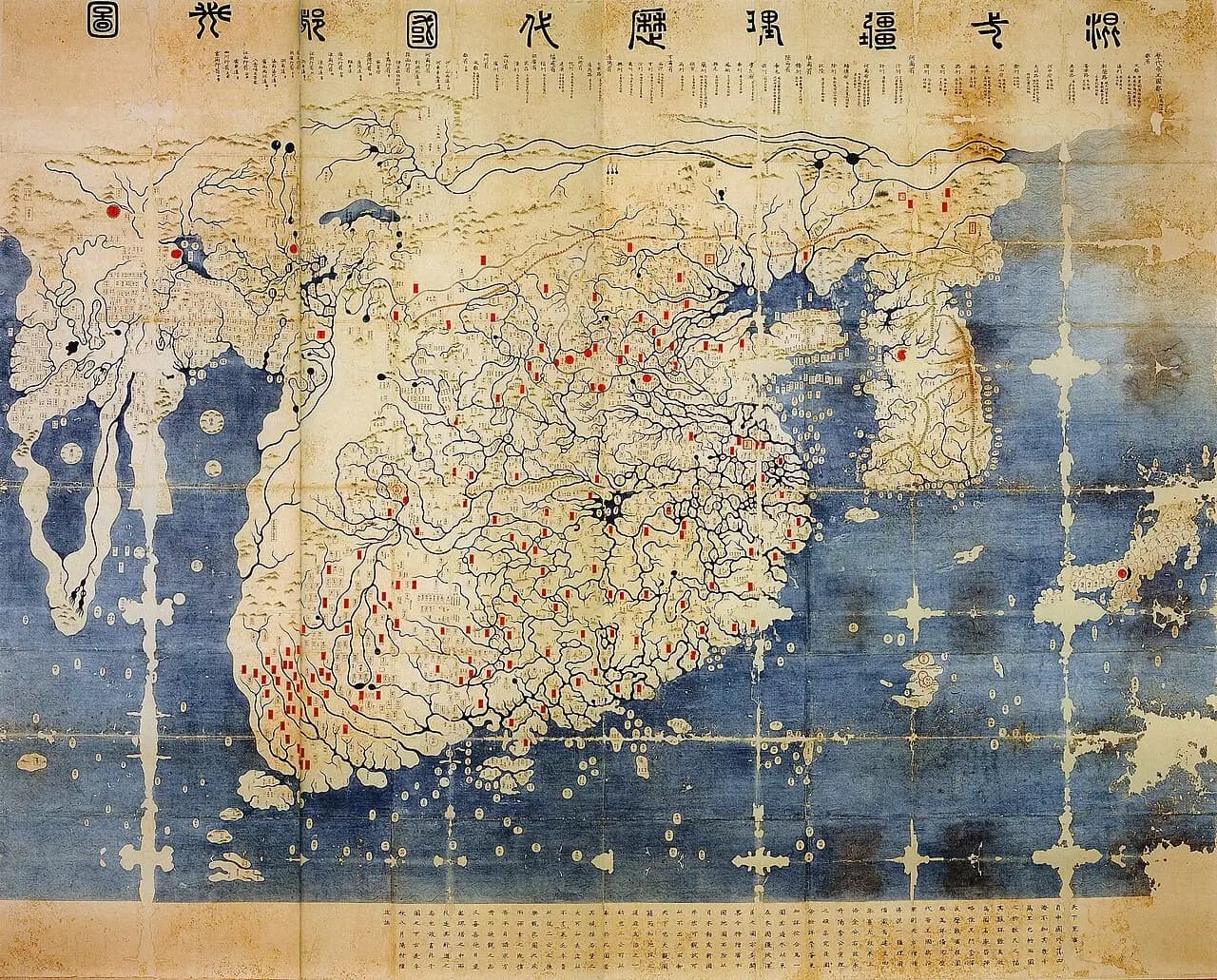
The oldest copy of the Kangnido is a map painted on silk. It measures about 164 by 171 centimeters and shows Korea, China, Japan, the Arabian Peninsula, Africa and Europe on one sheet.
The Korean court finished the original in 1402. The original is lost.
The traditional view
Gari Ledyard wrote the chapter on Korea in the University of Chicago's History of Cartography. He says the Kangnido "easily predates any world map known from either China or Japan." He calls it the oldest world map to survive in the East Asian tradition.
The map's full title is Honil kangni yŏktae kukto chi to. The preface by Kwŏn Kŭn says two ministers, Kim Sahyŏng and Yi Mu, studied two Chinese maps and ordered an official named Yi Hoe to combine them. Yi Hoe then expanded the map of Korea and added a map of Japan.
Kwŏn Kŭn gives the purpose in his own words. In Ledyard's translation he writes that "by looking at maps one can know terrestrial distances and get help in the work of government."
No copy survives in Korea. Ledyard counts three versions in Japan. The oldest belongs to the library of Ryūkoku University in Kyoto. A further, much larger copy is kept at the Honkōji temple in Shimabara, Nagasaki. The prefecture designated it a cultural property in 1999 and says it is Korean made.
Ledyard reads the odd proportions as a Korean view of the world. Korea, in his words, is "easily occupying as much space as the whole African continent." He adds that Africa is "unduly small." He thinks it was probably displayed in a palace building frequented by the king and senior officials.
The Maps Behind the Map
The preface names its own sources. Ledyard says the international part came from a map by Li Zemin. For the non-Chinese areas he writes that the only plausible source is "Islamic maps, which made their appearance in China under Mongol rule." A caption in the same chapter calls it "an unknown Islamic map."
Gavin Menzies reads the same map another way. His website lists the Kangnido among Chinese maps that escaped destruction. It gives the subject as "Asia, East, South and West Africa, Mediterranean, Atlantic, Azores."
Kenneth Robinson wrote a paper on Menzies's use of the map. The abstract says Menzies argues that its Africa "provides evidence that Ming China mapped the west coast of Africa and discovered the world in the 1420s." Robinson's abstract says that argument "does not stand in Korean and Chinese histories." I have read the abstract and not the paper. I have not read Menzies's book.
In Earthly Enigmas I treat the Piri Reis map as a compilation of older source maps. The Kangnido tells us in its own preface that it was built from older maps.
What The Copies Cannot Tell Us
Both views lean on questions the evidence cannot yet answer. Three of them stand out.
Why does the tip of Africa point south?
Ledyard describes the map's "African continent, with its tip correctly pointing south (not east, as on many early European maps)." He cites Takahashi Tadashi, who showed that the Chinese place names for Africa and Europe come from Persianized Arabic originals. Ledyard counts "about thirty-five names" on or near Africa.
Jérémie Eyssette writes in the International Journal of Korean History that the map "gives a Southern, not Eastern, orientation to the Southern tip of Africa" unlike previous Arab maps. In the same article he says "Africa is circumvented before Bartolemeu Dias's journey in 1488." I have not checked the Dias date.
A BBC report from 2002 describes a related Chinese map, the Da Ming Hunyi Tu. It describes the map as "Created in China in 1389, and clearly showing the shape of Africa, more than 100 years before Western explorers and map-makers reached the continent." I have not seen that map itself.
The part of the preface that Ledyard translates names the two Chinese maps. It does not say where Li Zemin found his western information.
Who first drew the tip of Africa pointing south, and from what?
How much of 1402 is in the copies?
Ledyard says the Ryūkoku copy is "dated based on internal evidence to about 1470." He adds that "if its source map was the 1402 Kangnido, then this is the last that is heard of this original."
Robinson's abstract says that "opinions on possible dates for the Ryukoku Kangnido have varied widely." He proposes "a revised date of between early 1479 and late 1485" from the Korean place names. He also suggests that the officials who made it were less interested in current images of neighboring countries than in "an up-to-date image of Chosŏn Korea." I have not read his paper to see what he says about the western half.
The Nagasaki prefecture page says the Honkōji copy was made in Korea. In my translation, place names put it in either 1513 to 1549 or 1567 to 1592. The English Wikipedia article says it was made in Japan in the Edo period with Korean place names revised around the 1560s, citing Miya Noriko. I have not checked Miya.
Eyssette says his own study rests on "Robinson's assumption that the shapes and proportions of the 1402 Kangnido are preserved on the Ryūkoku Kangnido." Any claim about what the 1402 map showed passes through that assumption.
Which parts of the surviving copies come from 1402 and which were updated later?
Where are the maps it was made from?
Ledyard writes that "apart from its use as a source for the Kangnido, nothing is known of Qingjun's map." He believes Qingjun's map supplied the Chinese historical layer.
Li Zemin's map supplied the world beyond China. Ledyard says place-name study points to a source map made about 1330. English Wikipedia reports that a text by Wu Sidao suggests Li's map came after 1360, again citing Miya. I have not checked that either.
Ledyard says Luo Hongxian probably used Li's map for his maps of the maritime regions, and that the Beijing map Da Ming Hunyi Tu "bears a very close resemblance to the Kangnido." The Guang Yutu article covers Luo's atlas.
Two Chinese source maps are lost. Li Zemin's map drew on an Islamic map that Ledyard calls unknown. What was that Islamic map, and does any copy survive?
The questions I can't put down
Some questions need more room than one article gives them. Two of them keep pulling me back.
Who can read the names in Europe? Ledyard says the European part holds about one hundred names. In 1994 he wrote that "until the place-names can be read and interpreted it will be impossible to come to any firm understanding of its sources." Eyssette's reference list includes a 2016 article by Nurlan Kenzheakhmet on the place names of Euro-Africa. I have not read it. I do follow the question of older source maps through the Piri Reis map in Earthly Enigmas, and the Piri Reis article sets out the arguments.
What was the map for? Ledyard thinks it hung where the king and senior officials would see it. Eyssette compares its inflated and missing areas to the methods of landscape painting. Kwŏn Kŭn says it let a viewer know the world without leaving the house. Ledyard's notes record that Takahashi matched four European names on the map to al-Idrisi's maps. The al-Idrisi world map article looks at that map. You can read a free sample of the book before you decide. The articles section has more subjects in the same format.
Sources
- Gari Ledyard, Cartography in Korea, in The History of Cartography, Volume Two, Book Two (University of Chicago Press, 1994), chapter 10
- Kenneth R. Robinson, Chosŏn Korea in the Ryūkoku Kangnido: Dating the Oldest Extant Korean Map of the World, Imago Mundi 59 (2007) (abstract only)
- Kenneth R. Robinson, Gavin Menzies, 1421, and the Ryūkoku Kangnido World Map, Ming Studies 61 (2010) (abstract only)
- Jérémie Eyssette, article on the Ryūkoku Kangnido and Oronce Fine, International Journal of Korean History 26
- Gavin Menzies, Chinese maps, star charts and records which escaped destruction
- Nagasaki Prefecture cultural property database: Honil kangni yŏktae kukto chi to (Honkōji copy) (Japanese, my translation)
- BBC News: Africa's oldest map unveiled (2002)
- Wikipedia: Gangnido (secondary, for the Wu Sidao and Honkōji points, both from Miya Noriko)