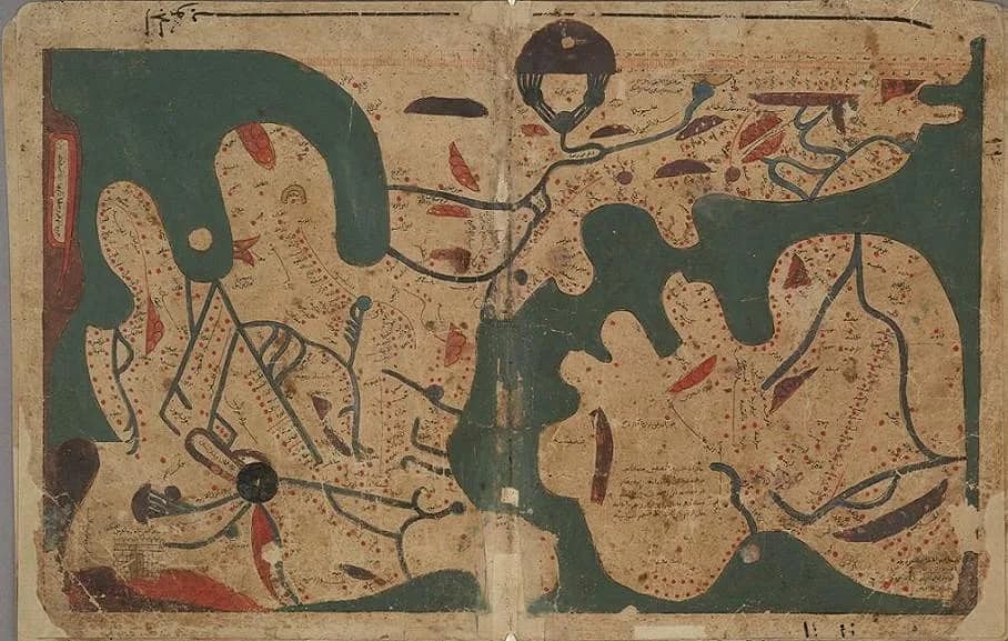
The manuscript went up for sale at Christie's in London with a bird dropping on its cover. Emilie Savage-Smith, who was asked to look at it, calls it a rather scruffy thing.
Inside were forty-eight leaves of brown paper and a map of the world with south at the top. Modern scholars did not know the treatise existed.
The traditional view
The Bodleian Libraries in Oxford hold the manuscript as MS. Arab. c. 90. The catalogue calls it an incomplete copy, probably made in Egypt, with a date statement of 1190 to 1210. The original is an anonymous work compiled in Egypt between AD 1020 and 1050. The library bought the manuscript from the dealer Sam Fogg in 2002.
Yossef Rapoport and Emilie Savage-Smith translate the Arabic title loosely as the book of curiosities of the sciences and marvels for the eye. They write in Lost Maps of the Caliphs that the treatise has ten chapters on the heavens and twenty-five on the Earth. They say nobody knows the name of the author or the patron.
The rectangular world map fills folios 23b and 24a. Rapoport calls it unlike any other world map known to us from any place or any time. Savage-Smith says it is the earliest world map annotated with the names of cities, 395 of them.
A scale bar runs along the top. Rapoport describes it as the earliest surviving example of such a scale on a world map in Islamic or European cartography, and possibly in any known mapmaking tradition.
The author says the map comes from Ptolemy's Geography and shows the inhabited world from the equator to 66 degrees north. Rapoport explains that this is why Africa south of the equator is left off.
Specialists checked the manuscript for forgery. Savage-Smith reports that pigment tests found six pigments and no modern inks. She also reports that every scholar who examined the volume was convinced of its genuineness. Eight later copies of the text, made between 1564 and 1741, turned up in other libraries.
What the Evidence Does Not Settle
In Earthly Enigmas I treat the Piri Reis map as a compilation of older source maps. I write that someone before 1513 mapped the Atlantic coastlines with unusual accuracy.
The editors of the Book of Curiosities argue that its world map descends from an older map that no longer survives.
The Map Behind the Map
Both views lean on questions the evidence cannot yet answer. Three of them stand out.
Where is the map behind the map?
The manuscript says its world map comes from Ptolemy's Geography. Rapoport writes that "no map of his survived." The influential later Ptolemaic world maps are all reconstructions.
Rapoport and Savage-Smith argue that the edges of the Book of Curiosities map carry the vestiges of a Late Antique prototype attributed to Ptolemy. They add that the attribution to the Geography is probably imprecise.
The scale bar is the best clue to that prototype. They also write that the scale is "corrupt and useless." In their words it "has no bearing on the position of any of the localities."
Others read the map differently. Rapoport reports that Andreas Kaplony saw a strange variation on the maps of the tenth-century Balkhi School and downplayed the scale. Some historians call the map a grotesque collage. Rapoport answers that the interior is indeed a collage of Ibn Hawqal's regional maps and the framework is something else. I have not read Kaplony's own work.
The reviewer Daniel Varisco adds a different point. He notes that the manuscript appears to have no influence on later texts. He says this calls into question its value as a picture of a shared Islamic cosmology.
If the older map is lost, what would count as evidence that it existed?
Why is Europe so big?
Rapoport describes Europe on the map as an enormously distorted island, mostly taken up by an oversized Iberian Peninsula. Asia is tightly squeezed beyond recognition.
He says Europe and North Africa fill what should be about 80 to 85 degrees of longitude. Al-Khwarizmi's coordinates give the Mediterranean about 43 degrees and 20 minutes.
Rapoport offers several explanations. The author or the copyist may have made a mistake. The corrupt scale may have misled one of them. The mapmaker may have chosen to stretch Europe to fit a long itinerary through Iberia. The map may also have been copied from something much larger.
On that last point Rapoport cites the fifteenth-century historian al-Maqrizi. He reports that looters of the Fatimid palaces in 1068 found a world map on cloth. It was woven with gold and dyed silks and made for the caliph al-Muizz in 964. Its value was 22,000 dinars. Rapoport writes that whether it was a prototype for this map "is impossible to confirm, but remains a tantalizing possibility." I have not read al-Maqrizi.
Was the stretch a slip, a choice or the mark of a copy made from something much larger?
What is missing?
Nothing in the surviving text or maps mentions a port in the Red Sea. Rapoport calls this a strange omission, because any Fatimid involvement in the Indian Ocean had to pass through it. He writes that "We can only speculate."
Chapters 8 and 9 of the book on the Earth are missing from both the Bodleian copy and a copy now in Damascus. Rapoport thinks they may have held sea maps of the Red Sea and the Persian Gulf.
Other pieces are gone as well. The later copies lack the two world maps and the large sea and island maps. Rapoport and Savage-Smith write that the author's earlier book is not known to survive. A summary on Muslim Heritage says the original treatise had three further books, on horses, camels and hunting. I have not checked that in the printed edition.
What did the missing chapters show?
The questions I can't put down
Some questions need more room than one article gives them. Two of them keep pulling me back.
Whose is the circular map? A near identical circular world map sits in this manuscript and in six manuscripts of al-Idrisi's twelfth-century book. Savage-Smith dates it to the original treatise. Rapoport thinks it was added to the copy later. Savage-Smith writes that "at this point we simply cannot say whose interpretation is correct." The al-Idrisi article follows the dispute. In Chapter 5 I write that older source maps lie behind the Piri Reis map, and I follow that thread through Earthly Enigmas.
How does a book go unknown for centuries? Rapoport and Savage-Smith report that eight later copies of the text sat unnoticed in libraries, one of them in the Bodleian since 1611. They note that tens of thousands of Arabic manuscripts remain unstudied. The first published date was wrong because of one undotted word. In the book I ask what the great archives hold and who is able to search them. You can read a free sample before you decide. The articles section has more subjects in the same format.
Sources
- Digital Bodleian: MS. Arab. c. 90, The Book of Curiosities
- Digital Humanities at Oxford: Book of Curiosities, an early 11th-century Arabic cosmography
- Yossef Rapoport and Emilie Savage-Smith, Lost Maps of the Caliphs (University of Chicago Press, 2018) (text read on a third-party host)
- Savage-Smith and Rapoport, An Eleventh-Century Egyptian Guide to the Universe (Brill, 2014) (abstract page only)
- Daniel Varisco, review of Lost Maps of the Caliphs, Peregrinations 7.2 (2020)
- Muslim Heritage: The Book of Curiosities or A Medieval Islamic View of the Cosmos (secondary, for the three further books only)