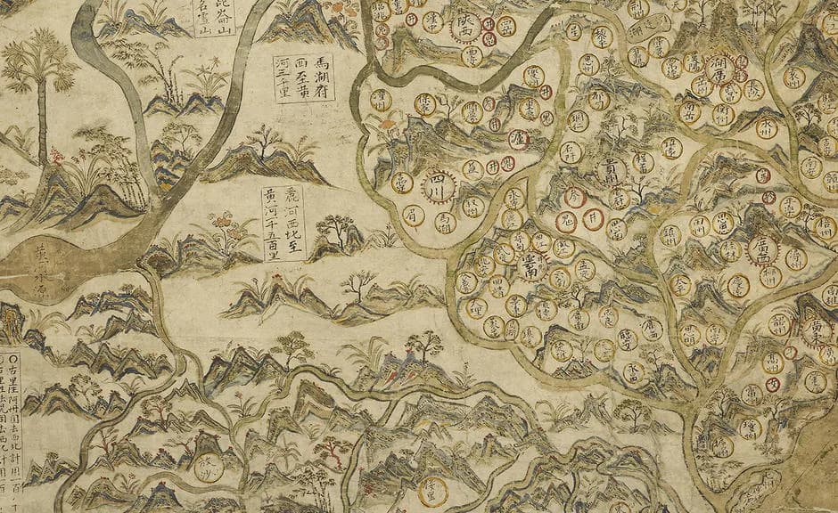
The map is about 1.6 meters wide and 1 meter tall. It looks like a Chinese landscape painting, with hills and trees and tiny walled towns.
Thin lines run across the sea between the ports. On the back of the sheet, the restorers found the main routes drawn out once already.
The traditional view
The Bodleian Libraries say the map arrived in Oxford in 1659 with the bequest of the London lawyer John Selden. It is painted in watercolors and ink on Chinese paper and the library thinks it dates from the 1620s.
The library's Selden Map site says the map is "not just a map of China, but of the whole of East and Southeast Asia." China fills less than half of it. The site says the map is centered on the South China Sea.
The same site says shipping routes with compass bearings radiate from the port of Quanzhou to all the areas the map covers. It calls the map "the earliest example of Chinese merchant cartography, unique in not being a product of the imperial bureaucracy."
Robert Batchelor noticed the routes in January 2008. In his 2014 article for Education About Asia he describes the map as the earliest surviving Chinese map made by maritime merchants. He dates it to about 1619.
The scale bar counts ship's watches, which Batchelor describes as the length of time for a piece of incense to burn, or about 2.4 hours. He writes that the routes were drawn before the coastlines, cities and other features. The restoration in 2011 showed this.
The mapmaker took the outline of China from somewhere else. A 2016 study in Heritage Science says the China part was closely copied from a popular Fujianese encyclopedia of 1599. The authors point to an unorthodox form of the character for "country" that appears in both.
The Bodleian site says the map was "almost certainly produced for reference in the house of a rich merchant rather than for use at sea."
Charts Nobody Has Found
In Earthly Enigmas I do not discuss the Selden Map. The nearest ground is the Piri Reis chapter. There I read the 1513 map as a compilation of older source maps drawn with unusual accuracy, and I argue that a global network needs global knowledge.
The Selden Map raises a smaller version of the same question. It shows a method of drawing that its own library says has no Western parallel, and the earlier work that method would need has not turned up.
What The Map Does Not Say
Both views lean on questions the evidence cannot yet answer. Three of them stand out.
Who drew it, and where?
The Bodleian site is direct about this. It says "it is not known exactly when and where the map was drawn, or who drew it and for what purpose." It adds that the compiler was probably a Chinese based in Southeast Asia.
The dates are not settled either. The library's main page says the 1620s. Batchelor says about 1619. The authors of the Heritage Science study write that historians have proposed dates between 1607 and 1619. Wesa Perttola, in a 2021 paper in the Journal of Archaeological Method and Theory, gives opinions ranging from the Wanli era (1566 to 1602) to 1624. He finds Batchelor's date the most plausible.
The same study adds a material argument. The authors found that the binding medium was a gum, almost certainly gum Arabic, "rather than the animal glue commonly used in Chinese paintings." They note that the pigment mixtures are at odds with common practice in paintings from China.
They propose that the map was made in Aceh, at the northwest tip of Sumatra. They say the tilt of the compass rose fits the magnetic declination of Aceh better than that of any other port on the map. They add that the map's axis roughly runs through Beijing, so the tilt could reflect Beijing instead. They also write that "further historical investigation is necessary to test this hypothesis."
Batchelor's published abstract says he suggests a possible patron and location of composition. I have not read his full article. In 2014 he also points to the back of the map. It carries a "mysterious and as of yet unidentified inscription" that may hold clues to when, where and by whom the map was made.
If the library, the historian and the scientists each point to a different place, what would settle it?
Where are the charts it grew from?
The Bodleian site says the old backing revealed the main sea routes drawn on the reverse. In its words this showed "not only that this was a first draft, but that the map was being drawn by systematic geometric techniques." It calls this "the first Chinese map to be produced in this way" and says the use of compass voyage data and distances counted in watches is "a technique with no western parallel."
Batchelor writes that the map reveals "previously unknown chart-making techniques." The Heritage Science authors say that Chinese maps before the twentieth century did not have a compass rose or a scale bar.
A method like this usually has a history. Perttola notes that the Laud rutter, a Chinese sailing manual kept in the Bodleian, uses the same compass and watch system and covers some of the same routes. He gives that manual an early fifteenth century date and cites a 1979 study by Mills. Elke Papelitzky, in the Journal of Chinese History, dates it to the late sixteenth century.
Papelitzky adds that the two sailing manuals in the Bodleian are fair copies of rutters. She writes that "we have no actual Ming or early Qing rutter that was aboard a ship."
The Zheng He charts of the fifteenth century are the other well-known Chinese sea charts. The Heritage Science authors say that on those charts the routes were not drawn according to their compass directions. Batchelor says the Zheng He charts were first printed in the Wubei zhi around 1628.
So the method that the Bodleian calls new has a few older relatives in text and no earlier relatives as drawn charts that I have found. I have not searched the Chinese-language literature. Where are the charts a merchant mapmaker learned this from?
Was it made for the sea or for the wall?
The Bodleian site says the map was almost certainly made for reference in a rich merchant's house rather than for use at sea. Perttola agrees that it was more likely meant for a prosperous household. He puts its size at about 158 by 96 centimeters.
The map is still drawn to compass bearings. Perttola reports that Stephen Davies read the scale as ship's watches and calculated speeds between one and nine knots across the map. For the Manila to Brunei route he gets 4.3 knots, which is close to the 4 knots he gives as the average for the Laud rutter.
Perttola then ran his own sailing model against the map. He writes that the simulated durations matched the values calculated from the map "reasonably well" in favorable winds. The model could not simulate tacking in adverse conditions.
Other readings are less kind. The Heritage Science authors say many routes are off their marked bearings where they had to fit a coastline. The route from the Strait of Malacca to Calicut is more than 30 degrees off, because the map ran out of space. They also write that the map probably fell into neglect after the astronomer Edmond Halley dismissed it as cartographically incorrect.
The Bodleian site takes the opposite view of one part. It says the map's depiction of Southeast Asia "was to remain the most accurate for another two centuries."
The library calls the map accurate enough to hold its place for two centuries and also says it was drawn for a wall. Who was it meant to inform?
The questions I can't put down
Some questions need more room than one article gives them. Two of them keep pulling me back.
How did it reach England? John Selden's will describes it as taken by an English commander who would not give it back even for a great ransom. The Bodleian site says he perhaps got it from an East India Company trader who took it from another vessel in the South China Sea. It adds that the company's records make no mention of it. I follow the wider question of how old maps travel and survive through Earthly Enigmas, and the Piri Reis article sets out another map with a disputed trail.
Why does the map show a city that had already fallen? Batchelor points to the walls and palace of Hami in the northwest corner and writes that the city had fallen to the Mongols in 1513. The rest of the map is up to date enough to show the Spanish and Dutch contest over Ternate. In Chapter 11 of the book I follow the idea that knowledge gets carried forward by copying. You can read a free sample before you decide. The articles section has more subjects in the same format, including the Guang yu tu and Matteo Ricci's 1602 world map.
Sources
- Bodleian Libraries: The Selden Map of China
- Bodleian Libraries: The Selden Map conservation project
- Bodleian Libraries: The Selden Map of China (project site)
- Robert Batchelor, The Selden Map and the Archipelagos of East and Southeast Asia, Education About Asia (2014)
- Robert Batchelor, The Selden Map Rediscovered, Imago Mundi (2013) (abstract only)
- Kogou and others, The origins of the Selden map of China, Heritage Science (2016, open access)
- Wesa Perttola, Digital Navigator on the Seas of the Selden Map of China, Journal of Archaeological Method and Theory (2021, open access)
- Elke Papelitzky, Sailing the Waters of East and Southeast Asia, Journal of Chinese History (2025)