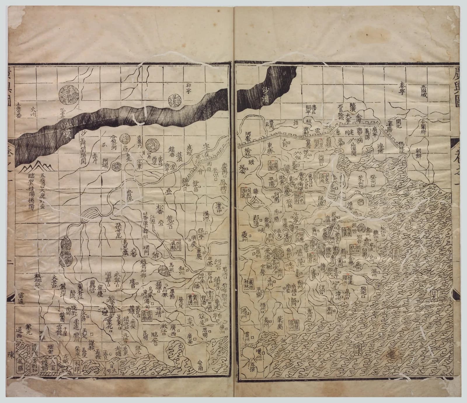
The maps in the Guang yu tu sit on a grid of small squares. Each square stands for a fixed distance on the ground.
The atlas names the man who drew the original maps. The original has not survived.
The traditional view
The Library of Congress calls the Guang yu tu "the oldest extant comprehensive atlas of China." It credits the Ming cartographer Luo Hongxian, who lived from 1504 to 1564.
The library says the atlas is based on the Yuan dynasty Yu di tu by Zhu Siben. It says Luo "supposedly acquired a copy of Zhu Siben's map, no longer extant." He then drew his maps "on a grid scale, which then were bound in book form."
The copy discussed here is dated 1579 and held by Taiwan's National Central Library. Qian Dai issued it in two juan. The library counts 16 maps on 93 leaves in the first juan and 27 maps on 106 leaves in the second. It adds that "Seven prefaces precede the atlas."
Joseph Needham translates Luo's preface in Science and Civilisation in China. In his rendering Luo writes that Zhu's map "was prepared by the method of indicating the distances by a network of squares." Luo adds that the map "was 7 ft. long and therefore inconvenient to unroll." He arranged it in book form "on the basis of its network of squares."
Needham says the scale was usually 100 li to each division. Cordell Yee points to a second use for the grid. He writes that it gave register marks so that two sections joined along their edges would match.
The atlas traveled far. The Library of Congress says that until the late 17th century "maps of China published in Europe were, without exception, drawn on the basis of this work."
One counterpoint comes from Richard Smith, who studied Chinese world maps. He writes that most large-scale Chinese maps of the late imperial era "continued to conform to the gridless Huayi tu cartographic model." The grid atlas was one tradition among several. Smith's text is a 1996 conference draft that asks not to be cited without permission, so I give it only as his stated view.
The Map Behind The Map
In Earthly Enigmas I do not discuss the Guang yu tu. The nearest ground is the Piri Reis chapter. There I read the map as a compilation of older source maps drawn with unusual accuracy, and I write that a global network needs global knowledge.
The Guang yu tu sits on the same shelf for one plain reason. It also rests on a map that has not survived, and that map rests on earlier ones.
What The Grid Cannot Tell Us
Both views lean on questions the evidence cannot yet answer. Three of them stand out.
Where is the map it was copied from?
The Library of Congress says Zhu's map is "no longer extant." Needham dates its preparation between 1311 and 1320. He says it was "a large one, not dissected."
Needham also says that "an epigraphic copy was still extant in +1715." Another note says that "Rare copies in manuscript and inscribed on stone in a Taoist temple lasted till the + 19th century but have all been lost."
Liu Gang, a collector of Chinese maps, writes that Luo "searched for three years and luckily found a map made by Zhu Siben." Liu concludes that the original "seems to have been extant as late as the 18th century." I have not checked his source for that.
Zhu himself worked from older maps. Needham says Zhu consulted the Yu ji tu of 1137, which he places carved in stone at Xi'an. Needham also says the maps of Pei Xiu, from the third century, "did not survive in any form."
Luo drew on other sources too. Needham says he "naturally drew on many other Yuan and Ming sources." Smith says that unlike Zhu's map, Luo's atlas includes 24 cartographic legends.
If the atlas is the only window onto Zhu's map, how can anyone tell which parts are Zhu's and which are Luo's?
How did a map with no coordinates get the coast so close?
Needham calls the 1137 Yu ji tu a map that "does the greatest credit to the Sung cartographers." He says its inscription gives the grid scale as 100 li to a square. A comparison of its rivers with a modern chart shows, in his words, "the extraordinary correctness of the pattern."
He adds in a note that Heawood judged it superior to the best Hellenistic efforts. The same note says "There was nothing like it in Europe till the Escorial MS. map of about +1550."
Pei Xiu's preface, in Needham's translation, makes a large claim for the grid. Properly applied, it says, "the straight and the curved, the near and the far, can conceal nothing of their form from us." Yee disagrees about the date of the grid. He writes that it was "probably not employed by Pei Xiu."
Yee is open about what stood behind Zhu's own map. He writes that Zhu "relied on earlier maps (including the Yu ji tu), literary sources, and personal observations, not necessarily on survey measurements." He also discusses the grid and scale marks. They perhaps warrant the view that maps like the Yu ji tu "relied at least in part on direct and indirect measurements of ground distances."
Both statements come from the same chapter. One says the distances were perhaps partly measured. The other says the work may have been compiled from older maps and texts.
What measurements stand behind a coastline drawn in squares?
What did Zhu draw beyond China?
Zhu wrote a caution about distant lands. In Needham's translation he says there is "no means of investigating them because of their great distance." He adds that "hence I am compelled to omit them here."
Needham then reports a surprise. He writes that "the tip of Africa" is always shown "pointing eastwards" in European and Arabic maps of the 14th century. He says this was "not corrected until the middle of the + 15th century." He says the Chinese atlas of 1555 "has it pointing south." He adds that "other evidence shows that Chu Ssu-Pén must have drawn it in this way as early as + 1315." He credits Walter Fuchs for pointing this out.
Needham adds a note on this very edition. He writes that Wang Yung "is wrong in supposing that the map containing Africa was introduced only in the edition of +1579 edited by Chhien Tai." I have not looked for that map in the digital copy of the 1579 printing.
Smith names another source for Africa on the early Ming Da Ming hunyi tu. He writes that its renderings of Africa and Europe "appear to have been based at least in part on Li Zemin's" map, which is also "no longer extant."
Liu Gang goes further. He argues that Zhu's map "is in fact a world map, and that Zhu used double rings for the Eastern and the Western hemispheres." He says Chinese historians have misread Zhu's phrase about omitting distant lands and a sentence in Luo's preface. I cannot read the Chinese and I have not checked his reading.
Yee reads Zhu's own words differently. He writes that some foreign countries "were omitted from the Yutu because Zhu lacked reliable information."
Zhu's words can be read in more than one way, and the map he made is gone. What did the lost map show beyond China?
The questions I can't put down
Some questions need more room than one article gives them. Two of them keep pulling me back.
Why did Europe's maps of China all come from one Chinese atlas? The Library of Congress says that until the late 17th century every such map was drawn on the basis of this work. I follow the wider question of older source maps through Earthly Enigmas and in the Piri Reis article.
Which printing is on the screen? The Library of Congress says the first edition was issued in 1561 by Hu Song. Needham says Luo revised the map in 1541 and that it was printed about 1555. Smith says it was first published in 1579. The library's viewer shows 17 images in its first volume and 25 in its second, while its catalog counts 93 and 106 leaves. I have not checked what each image shows. You can read a free sample of the book before you decide. The articles section has more maps in the same format.
Sources
- Library of Congress: Guang yu tu, 1579 printing, World Digital Library
- Library of Congress: Guang yu tu, volume 2, image 2
- Joseph Needham, Science and Civilisation in China, vol. 3 (1959), section 22, Geography and Cartography
- Cordell Yee, Taking the World's Measure: Chinese Maps between Observation and Text, in The History of Cartography vol. 2 book 2
- Richard J. Smith, Mapping China's World (1996 conference draft)
- Liu Gang, The Chinese Inventor of Bi-Hemispherical World Map, e-Perimetron 2 no. 3 (2007)