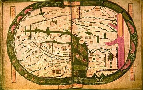
A map of the world spreads across two facing pages of a book made in a Gascon abbey. East is at the top, where Adam and Eve stand in the garden. Near the western edge a drawing of the abbey itself sits almost as large as Rome.
The map carries more than 300 names. The specialists give different answers on where those names came from. The book sits in the Bibliothèque nationale de France as Latin 8878.
The traditional view
The Bibliothèque nationale de France says the Beatus manuscripts carry a Commentary on the Apocalypse written by the eighth-century monk Beatus of Liébana. It counts 26 illuminated copies from the ninth to the thirteenth century. All were copied in Spain except the Saint-Sever copy and one Italian copy.
Emmanuelle Vagnon counts differently in her article on the map. She gives 32 surviving copies, 24 of them richly illustrated, and 16 of those with a world map. She takes the figures from Sandra Sáenz-López Pérez. I have not checked either count.
The BnF says the Saint-Sever copy was made around 1060 in the Gascon abbey and conceived by Abbot Gregory of Montaner, who commissioned the decoration from three artists. The BnF page on the manuscript's history gives his years as abbot as 1028 to 1072.
The BnF describes the map as unique in its layout, in the number of its place names and in the abundance and length of its legends (my translation). It calls the map a sum of the geographical knowledge available in the eleventh century.
The BnF's teaching page on the map says two painters worked on it, one for each page, and that a single hand wrote the legends. It lists more than 300 elements. East is at the top, with Eden, Adam and Eve and four rivers. Jerusalem, Carthage and Babylon are marked. Rome, Constantinople and the abbey are drawn at almost the same size.
The same page gives the map a purpose. It calls it a map of the evangelization of the nations by the twelve apostles. The map closes the prologue to the second book of the Commentary.
The manuscript had a rough history. The BnF says the abbey library was pillaged in 1569 and 1570. Only the Beatus and a necrology were put out of harm's way. The book resurfaced at a sale in 1769 and has been in the national collections since 1790.
Keepers of Old Geography
In Chapter 11 I follow how knowledge is carried forward by people who keep it. I write that "the stories were in the library" and that human memory was the medium (p276).
Vagnon says most of the place names on the Saint-Sever map come from classical sources. She names Pliny the Elder and Solinus, as passed on by Isidore and Orosius. She says the structure of the map follows an ancient cosmography taught in the monastic schools.
A Map Everyone Reads Differently
The scholars agree that the map sits in a book about the end of time. They part ways on what the map was for and where its names came from. Three questions stand out.
Where does the map put the abbey?
The BnF's main page on the manuscript says the map gives the abbey a central geographical position. It says the abbey presents itself as a new western Jerusalem (my translation). The BnF's teaching page says Jerusalem is at the center.
Vagnon sees it another way. She writes that neither the Albi map nor the Saint-Sever map has a well-defined center. She says the drawing of the abbey dominates and plays the role of the westernmost point of Christendom. She adds that Jerusalem is given no more weight than the other patriarchates.
The Davis monograph on the Beatus maps says the scribe drew the humble church of Saint-Sever as large as the city symbols of Rome and Constantinople. It says he wanted to please his patron.
The sources also differ on why Gascony is so large. The monograph quotes an unnamed scholar saying the map reflects an overriding interest in "the political organization of the Gascon principality" at the start of Gregory's rule. Vagnon says the abbey's picture can be read as a manifesto of the role it meant to play in evangelizing the kingdom of the Franks. She adds that Jean Cabanot noted that Cluny and Fleury are missing, which points away from church geography as the map's first job.
Sandra Sáenz-López Pérez titled a chapter The Image of France in the Beatus Map of Saint-Sever. I could not read it. The publisher page I opened shows an abstract about a different subject, so I did not use it.
What was the drawing of the abbey meant to say, and to whom?
A copy of an older map or a map built in Gascony?
The monograph reports that Neuss judged the Saint-Sever map the closest to the first Beatus map. It quotes him saying the map is "by far the most complete" and "the most antique in every respect". Konrad Miller disagreed because so many names are medieval. The monograph says the map has 270 names. It says many of the post-Antique additions, 50 places, 10 rivers and six provinces, are concentrated in a hugely exaggerated Gascony. It says Peter Klein's 1976 work effectively removed the map as a contender for the closest copy. The wider argument over which Beatus map is closest is in the Burgo de Osma Beatus article.
In a descriptive passage with no named author, the monograph says the quality of the map led some to think it a faithful copy of a Roman original. The same passage says the many medieval names and the emphasis on Gascony point to "a local and contemporary production."
Vagnon takes the second view with a twist. She finds that a rare place name, Antiochia Tarmata, appears on this map, on the Peutinger Table and in the Cosmography of Ravenna. She finds many matches with a list of places in a treatise on the astrolabe. The treatise carries the name of Gerbert of Aurillac, though she says that attribution is highly uncertain. She concludes that the astrolabe author and the designer of the map used a common source, an oval or circular map of some detail (my translation).
She reports that Patrick Gautier Dalché rejected Nikola Bubnov's earlier idea of a similar map behind the astrolabe list. He pointed out that the places in the list do not line up with the map. In the same article she calls Konrad Miller's common-source hypothesis an easy way out, since nobody knows what that parent map looked like. She prefers to stress the inventiveness of medieval scholars who built new models from varied materials. Her file on HAL is marked as an uncorrected first version of the published article.
Was there an older, more detailed map behind this one?
Whose hands drew it, and when?
A faint line on folio 6 reads "Stephanus Garsia Placid. ads." The BnF's teaching page says it has been read in more than one way. It could be one scribe with a title. It could be the signature of the three scribes whose hands run through the book. It could name three painters if the last word means "they are present" (my translation).
Vagnon reports that François Avril identified three main scribes and that Charlotte Denoël thinks the signature names the three artists. The Davis monograph says the scribe signs as Stephanus Garsia and dedicates the work to his abbot. The AGORHA database lists Stephanus, Garsia and Placidus as painters and three scribes as A, B and C.
For the map itself, Vagnon says two painters worked on it. A single hand lettered the names in red uncial letters and the legends in brown cursive, perhaps the master of the work. She also writes that the designer was "certainly" Abbot Gregory himself.
The date has a range. The BnF says around 1060. AGORHA says third quarter of the eleventh century and before 1072. Woodward's table of map colors in The History of Cartography gives about 1050. Vagnon puts the fire that damaged the abbey at about 1065. The BnF page places the fire and the rebuilding in 1065 to 1070.
A lab study may help. The BnF page points to physico-chemical analyses of the illuminations at the Center for Research and Restoration of the Museums of France. The center's page covers eight folios. AGORHA's record for the folio with the map lists ultramarine indicators, indigo, orpiment and vermilion. David Woodward wrote in 1987 that physical analysis of parchment, pigment and ink would give "some much-needed benchmarks in dating." I have not seen a dating result from the Saint-Sever study.
Who held the brushes, and who chose what went on the page?
The questions I can't put down
Some questions need more room than one article gives them. Two of them keep pulling me back.
How did this one book survive? The BnF says the abbey library was pillaged in 1569 and 1570 and the Beatus was saved in circumstances that remain obscure (my translation). Vagnon says a collector cut the map out at some unknown time. It turned up at a bookseller in 1866 and was set back into the manuscript. The Davis monograph suggests the map's large size led to its separation from the book and that it may have served as a wall map. In the book I follow what institutions keep and what they lose, in the section called "The Library That Cannot Be Searched."
How much did these monks know about the shape of the earth? Vagnon says the map follows a late antique scheme of a spherical earth with climate zones. She says a red band for the torrid zone, matched with the Red Sea, runs across the south. In Chapter 5 I write that building the great-circle network took measured knowledge of latitude and longitude. You can read a free sample of the book before you decide. The articles section has more subjects in the same format, including the Albi Mappa Mundi.
Sources
- BnF: Le Beatus de Saint-Sever (French; translations are mine)
- BnF Essentiels: Le Beatus de Saint-Sever, the manuscript's history and signature (French)
- BnF Essentiels: Mappemonde du Beatus de Saint-Sever (French)
- Emmanuelle Vagnon, Science de l'espace et du temps dans la mappemonde du Beatus de Saint-Sever, Les Cahiers de Saint-Michel de Cuxa 54 (2023) (French; the HAL file is an uncorrected first version; translations are mine)
- Henry Davis Consulting, The Beatus Maps, monograph #207 (a compiled secondary text; the scholars it names are cited as it reports them)
- AGORHA: Beatus de Saint-Sever, Mappemonde, Latin 8878 (French)
- AGORHA: Beatus de Saint-Sever, Latin 8878 (French)
- C2RMF: Analyse des enluminures du Beatus de Saint-Sever (French)
- David Woodward, Medieval Mappaemundi, The History of Cartography vol. 1, chapter 18 (University of Chicago Press, 1987)
- Sandra Sáenz-López Pérez, The Image of France in the Beatus Map of Saint-Sever (Routledge) (title only; not read)
- Wikipedia: Saint-Sever Beatus (read only to locate sources; nothing from it is used)