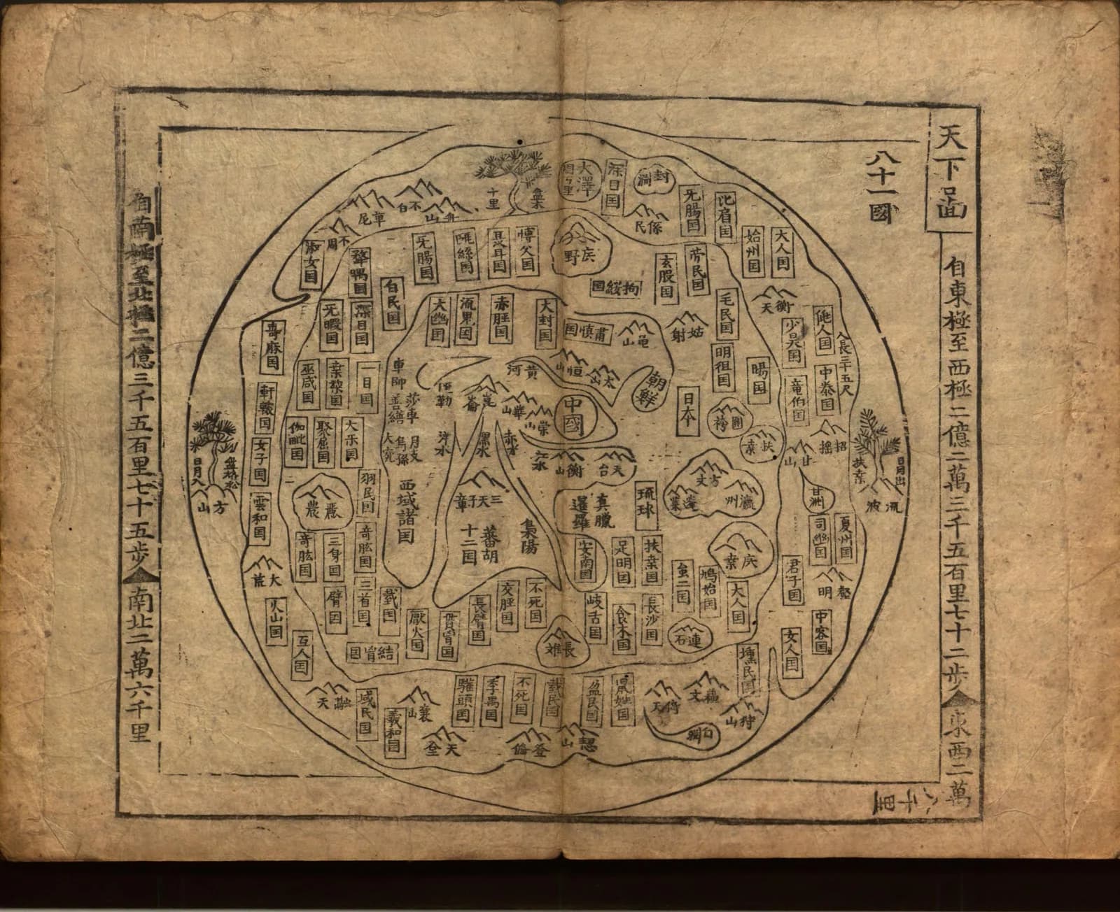
Open the Yochudo atlas at the Library of Congress and the first map you meet shows the eight provinces of Korea. Turn to image 10 and the world is a circle.
A flat continent sits in the middle. A ring of sea runs around it and a ring of land runs around that. The names on the outer rings belong to countries nobody has visited.
The traditional view
The Library of Congress describes the Yochudo as "a collection of maps created in Korea sometime prior to 1700." The same blog post says the atlas holds maps of Korea and its eight provinces and of three neighbors, China, Japan and the Ryukyu Kingdom.
The post calls the circular map a ch'onhado, "map of all under heaven." It says the style "was developed in part as a reaction to European-style world maps introduced by Christian missionaries to East Asia in the 16th-17th centuries." It adds that the Korean scholars who made the style "sought to portray the world through the lens of traditional culture."
Gari Ledyard wrote the chapter on Korea in the University of Chicago's History of Cartography. He describes the layout this way. "A main continent occupies the center of the circular map; it is surrounded by an enclosing sea ring, which itself is surrounded by an outer land ring." He counts 143 place names in all.
Ledyard says most of the countries shown are imaginary. He also says the list of them is "virtually identical from map to map." He found that over 72 percent of the names come from the Shanhai jing, the Classic of Mountains and Seas, an ancient Chinese book of geographical lore.
Oh Sang-Hak describes the same layout in the Korea Journal. He writes that the inner continent holds real countries, while the inner sea, the outer continent and the outer sea are filled with imaginary countries found in documents like the Shanhai jing. He adds that no identical world maps have turned up in China or Japan.
What the Rings Cannot Date
In Earthly Enigmas I argue that the Piri Reis map was built from older source maps. In Chapter 5 I write that someone mapped the Atlantic coastlines before 1513 with unusual accuracy, and I call the debate over it open.
Where They Don't Meet
Both views lean on questions the evidence cannot yet answer. Three of them stand out.
When was the Chonhado first drawn?
Ledyard writes that the genre "made a silent and utterly unnoticed debut at a date we cannot pin down even to the century." He says the copies "never bear any original date or maker's name."
Many Chonhado atlases carry a preface by a man who signs himself Yo On, dated to a kiyu year in the sixty-year cycle. Ledyard says that could be 1849 or any other year at sixty-year intervals. Kim Yangson assigns 1789 and Nakamura Hiroshi argues for 1849. Ledyard calls 1849 "the only fixed date that can be associated with the ch'onhado." He adds that Yo On was only a publisher or editor and that the map "certainly existed" before either date.
Nakamura concluded that the map in its present form probably does not go back earlier than the sixteenth century. Ledyard calls this "the best consensus view, nobody having made a convincing case for an earlier or a later date." He also writes that the map "cannot be documented before the seventeenth century but has been reasonably inferred to have arisen sometime in the sixteenth."
Oh Sang-Hak writes that "the prevailing view is that they were made in the seventeenth century or thereafter." He also writes that "no circular world atlases or folders, believed to have been made earlier, have been uncovered." He considers that fifteenth and sixteenth century versions might all have been lost and calls that possibility "very slim."
Hong-Key Yoon reaches a different place in the Geographical Review. I have seen his abstract only as a search result excerpt. As reported, it says the oldest remaining copy dates only to the seventeenth century and the map may have originated much earlier.
Kim Yangson proposed the fourteenth and fifteenth centuries. Ledyard says the fifteenth and sixteenth century records Kim cites most likely refer to Ming maps of China that had similar titles.
The Library of Congress gives "not after 1700" for its atlas. Every one of these dates rests on dated prefaces, similar titles or the copies that happen to survive. What would a firmly dated early copy have to look like?
Did the Western maps start it?
The Library of Congress blog says the style developed "in part as a reaction" to European maps. Oh Sang-Hak agrees that Western geographical knowledge "played a key role." His abstract says the maps were made "to represent the expanded understanding of geography" that came from that encounter. He adds that the maps relied on a traditional conception of the world for content and style.
Oh Sang-Hak reports that Unno Kazutaka and Bae Woo Sung sought the origin of the form in Western world maps. He answers that this "overemphasizes the impact of Western world maps." He notes that no Chinese translations of Western place names appear on the Chonhado.
Ledyard offers a third route. He suggests that the inner continent grew out of the Kangnido of 1402, the Korean world map that survives only in later copies. He proposes that Africa and Europe were folded into the Asian landmass. In his sketch the Arabian Peninsula becomes a triangular peninsula between two rivers, and the Mediterranean and Black seas become one inland sea. He calls the steps "concededly arbitrary." He says "the judges of the court of plausibility must render their verdict."
Nakamura had proposed a Buddhist Chinese map as the source. Ledyard writes that "the argument for a Buddhist origin for the ch'onhado is without merit." Oh Sang-Hak cites Nakamura's view and does not adopt it.
Ricci's world map reached Korea in the early seventeenth century, according to Oh Sang-Hak. The Matteo Ricci article covers that map and the Kangnido article covers the other. Is the Chonhado an answer to the West, a descendant of an older Korean map, or something with a source that is lost?
Why did it last so long?
Ledyard asks the question outright. He wants to know why such a "seemingly primitive map" was "so popular so late." He sets it against "more accurate and generally available world maps of Western origin." He says the literature "has so far not resolved the principal questions raised by the genre."
He offers part of an answer. Koreans, he writes, could relate to Western world maps "only with difficulty." The Chonhado placed China in the middle, showed Korea larger than Japan and named a foreign world that its users already knew from their own reading. In his words it "both related to and validated the cultural rearing of its users."
Context mattered too. Ledyard says the usual mode of publication was as the first map in an atlas, followed by China, Japan and the Ryukyus, then Korea and its eight provinces. He describes albums that "went from the general to the particular."
The Library of Congress blog shows something different for this atlas. It captions the first map as the eight provinces of Korea and gives the Chonhado as image 10. I have not been able to open the Library of Congress catalog record or the page sequence, so I cannot say how the other maps are ordered. Why would this atlas place the world after the Korean map?
Oh Sang-Hak adds a reading of the circle itself. He argues that "the circle in circular world maps represents not the earthly world but the sky." He points to one annotated print with the characters for "round heaven, square earth" and a yin-yang symbol drawn in a corner. Ledyard does not make this argument.
The questions I can't put down
Some questions need more room than one article gives them. Two of them keep pulling me back.
How many countries are on the map? The Library of Congress record reportedly lists eighty-one. I have only seen that figure in a search excerpt and I have not counted the names myself. Ledyard reports that the historian Sima Qian described the thinker Zou Yan's world as one China-sized zhou out of eighty-one that exist under heaven. I cannot say whether the two numbers are related. I do follow the question of older source maps through the Piri Reis map in Earthly Enigmas, and the Piri Reis article sets out the arguments.
Why those names in those places? Nakamura listed 143 names, and Ledyard's table puts 103 of them in the Shanhai jing. Ledyard says the names sit in positions that follow the directions of the old book, with some corner names shifted a quarter turn. He asks why these names were chosen and not others. He also asks what the basis is for their "virtually fixed locations on the map." He says a number of names are still unidentified as to source. You can read a free sample of the book before you decide. The articles section has more subjects in the same format.
Sources
- Library of Congress blog: Now Online, Korean Rare Book Digital Collection (2020)
- Library of Congress: Yŏch'udo, item record 2019412289 (not opened; the site blocked my requests, so I know it only through a search excerpt)
- Gari Ledyard, Cartography in Korea, in The History of Cartography, Volume Two, Book Two (University of Chicago Press, 1994), chapter 10
- Oh Sang-Hak, Circular World Maps of the Joseon Dynasty: Their Characteristics and Worldview, Korea Journal (Spring 2008)
- Hong-Key Yoon, Ch'onhado, a Traditional Korean Map of the World: A Debate on Whether it is a Product of Western Cultural Influence, Geographical Review 115:3 (2024) (abstract only, through a search excerpt)