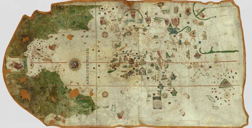
Juan de la Cosa's chart is painted on two calfskins joined together. It is a little under two meters wide. West of the Caribbean islands a figure of Saint Christopher carries the Christ child across the water.
A cartouche under the saint reads "Juan de la Cosa la fizo en el puerto de S. Mª en año de 1500." The Museo Naval in Madrid calls the chart the first known cartographic representation of the American continent. Alida Metcalf of Rice University writes that "The information for the Americas came from charts that no longer remain."
The traditional view
The Museo Naval holds the chart as catalog number 257. Its catalog text is in Spanish and I translate from it. It says Juan de la Cosa was master and owner of the Santa María on Columbus's first voyage in 1492. He sailed again with Columbus in 1493 and settled in El Puerto de Santa María in 1496.
In 1499 he served as chief pilot for Alonso de Ojeda along the coasts of Guyana, Paria and Venezuela. The catalog says that with the data gathered earlier he drew the chart on his return to Spain.
The Museo Naval says the chart shows the discoveries of Columbus on three voyages. It adds those of Ojeda, Vicente Yáñez Pinzón and Juan and Sebastián Cabot. Its story on Google Arts & Culture says the Americas "was based on notes made by transatlantic navigators, both from Spain and other rival powers."
Europe and the Mediterranean follow Mallorcan and Portuguese portolan charts. The Atlantic coast of Africa follows Portuguese charts. Asia rests on "Ptolemaic theories, myths and legends, and the chronicles of Italian explorers such as Marco Polo."
Factum Foundation recorded the original in 2021. It describes a map "caught between Medieval and modern cartography" and "in large part a portolan chart." It says the chart incorporates "lands which were unknown to earlier map-makers."
The chart also leaves out parts of the Americas. The Museo Naval catalog says the peninsulas of Florida and Yucatán, the Gulf of Mexico and Central America are missing. El País reports that the chart draws the equator and the Tropic of Cancer correctly. It adds that distances and latitudes are wrong in places, above all in the New World and the Antilles.
The same article reports on a test. In 1987 the Prado Museum examined the chart with X-rays, infrared and ultraviolet fluorescence. According to El País the pigments matched the date on the chart and no later repainting was seen.
The chart then dropped out of sight. The Museo Naval says it disappeared from the Casa de la Contratación in Seville "in circumstances never clarified." Baron Walckenaer bought it at an auction in Paris in 1832. The Spanish State bought it in 1853 for 4,321 francs.
What the Chart Leaves Open
Chapter 5 of Earthly Enigmas makes an argument about maps.
I treat the Piri Reis map as one correlation among several. I read it as a compilation of older source maps, and I write that someone, before 1513, had mapped the Atlantic coastlines with unusual accuracy. In the same chapter I write "Someone knew the whole planet."
The chart signed by Juan de la Cosa is dated thirteen years before the Piri Reis map. Whether it belongs in that argument is not something the book says.
Where the Sources Part Ways
Both views lean on questions the evidence cannot yet answer. Three of them stand out.
How firm is the date of 1500?
The cartouche gives 1500. The Museo Naval gives 1500 for the drawing. El País reports that the Prado's analysis found the pigments consistent with that date.
An independent researcher who runs the site Cartography Unchained disagrees about the date. He writes that the date of 1500 may have been "a political statement" and "a sleight of hand when it should be at least 1502AD to 1507AD." The site is self-published and I have not checked the author's credentials.
Cuba sits at the center of the argument. English Wikipedia says Cuba is drawn correctly as an island and that the first recorded circumnavigation did not come until 1508. New World Cartographic, a map dealer, writes that the rendering makes it clear Cuba is not part of Asia. I have not checked the outline on the chart image myself.
The 1911 Encyclopaedia Britannica adds that Columbus had the crews of his three caravels sign a document in June 1494. It says he had become convinced that he had found continental land.
A pigment test dates the paint. Does it also date the knowledge drawn with it?
Where are the charts behind the Americas?
The Museo Naval says the Americas come from notes by navigators of Spain and of rival powers. Metcalf says the charts they came from no longer remain.
Facsimile Finder is a dealer's site. It says the coast of America "is out of scale with most of the map, suggesting a different source for that part of the map." The Museo Naval credits Columbus, Ojeda, Pinzón and the Cabots as sources of the coasts.
Cartography Unchained transcribes notes on the northern coast that credit English discovery. He writes that the Spanish ambassador appears to have obtained the information but that "when is not known nor how it was transmitted." I have not checked those notes on the chart.
The Piri Reis map has the same gap. Its note says that the coasts and islands were taken from Columbus's map, and I have not seen a surviving copy of it. The Piri Reis article follows that question.
If La Cosa drew from the charts of other navigators, where are they now?
What was it for, and where was it for three centuries?
The Museo Naval says the chart's political importance most likely led the Catholic Monarchs to class it as a state secret. It says they are believed to be the ones it was drawn for. El País says La Cosa painted it at the request of Bishop Juan Rodríguez de Fonseca, who wanted to show the monarchs the new discoveries. Metcalf says it was most likely intended for Fonseca or for Ferdinand and Isabella.
El País says its trail was lost from 1514 until Walckenaer bought it in 1832. The Museo Naval says it vanished from the Casa de la Contratación without explanation. El País adds that Napoleonic troops stole it during the war of independence. I have not checked that claim and the Museo Naval does not repeat it.
The same Museo Naval catalog says the missing Florida, Yucatán, Gulf of Mexico and Central America were mostly covered by the cartouche. It uses the Spanish word "hábilmente" for the way the cover was done. That means cleverly or skillfully.
What did the chart hold that needed keeping, and who had it between 1514 and 1832?
The questions I can't put down
Some questions need more room than one article gives them. Two of them keep pulling me back.
Whose measurements are in the Caribbean? Facsimile Finder says the Caribbean islands are large and slightly misplaced, following Columbus's faulty calculations. El País says the equator and the Tropic of Cancer are right while distances and latitudes in the new lands are wrong. In Chapter 5 of Earthly Enigmas I argue that someone knew the whole planet, and I tie that to the Piri Reis map.
Why does a chart of the new lands carry the legend of Alexander the Great? The Museo Naval says the chart shows Gog and Magog and that their imprisonment by Alexander is a medieval legend. Piri Reis wrote that his charts were drawn in the days of Alexander. I raise the Alexander-era sources of the Piri Reis map in the book. You can read a free sample before you decide. The articles section has more subjects in the same format.
Sources
- Museo Naval, Carta universal de Juan de la Cosa (1500), catalog entry 257 (Centro Virtual Cervantes, Spanish)
- Museo Naval on Google Arts & Culture: Chart of Juan de la Cosa, The First Known Map of America
- Factum Foundation: The Map of Juan de la Cosa (2021)
- El País, 27 February 2024: El Museo Naval estudia sustituir el primer mapamundi de la historia por una réplica (Spanish, partly paywalled)
- Alida Metcalf, plate 4 note, Mapping an Atlantic World, Rice University
- Facsimile Finder: Map of Juan de la Cosa (dealer site, secondary)
- New World Cartographic: Juan de la Cosa and his World Chart (dealer essay, secondary)
- Cartography Unchained: The 1500 World Chart Analysed (independent, self-published)
- 1911 Encyclopaedia Britannica, Columbus, Christopher (Wikisource) (old, secondary)
- Wikipedia: Map of Juan de la Cosa (secondary, search excerpt only, for the Cuba and 1508 lines)
- Piri Reis article