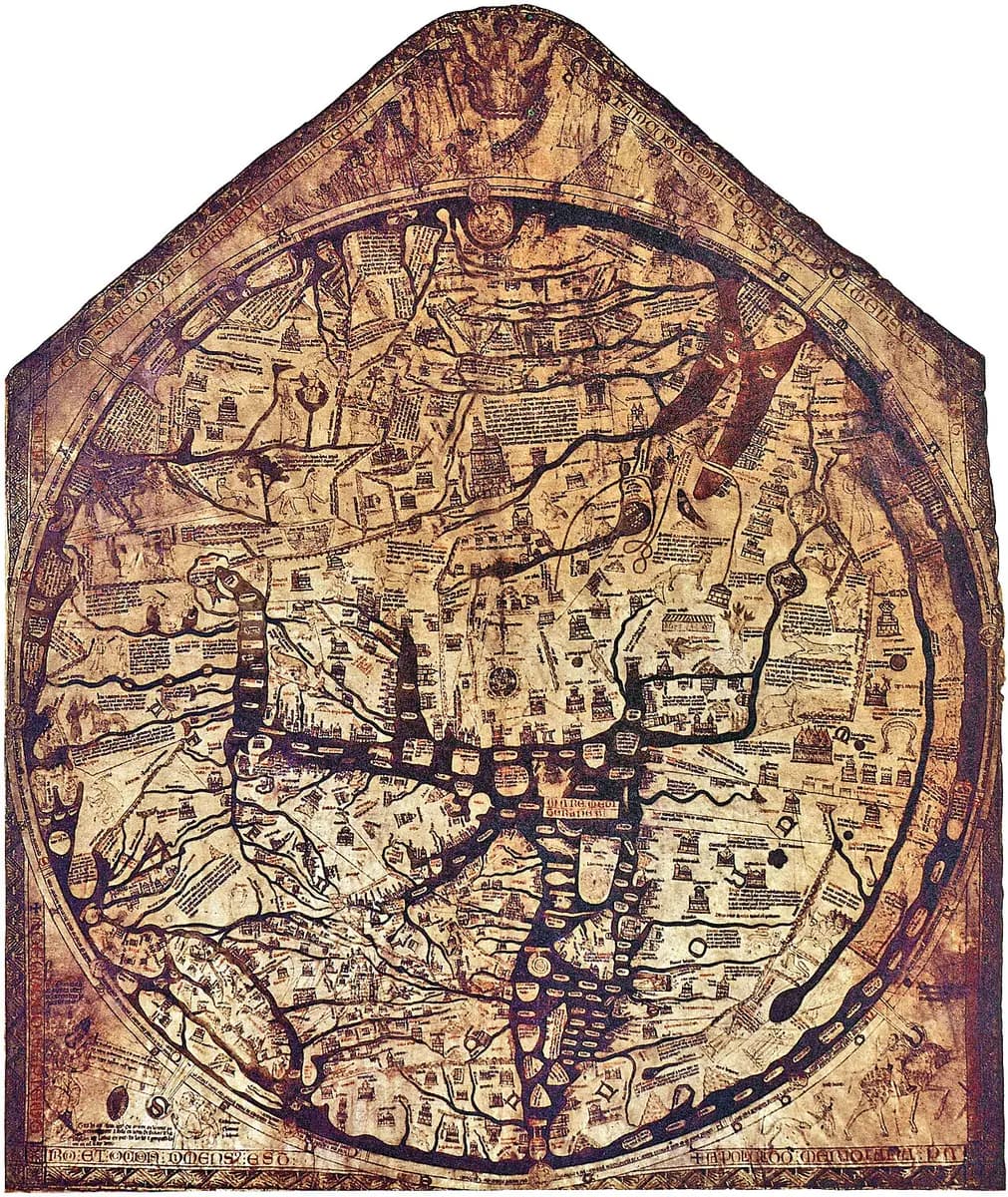
The sheet is 64 inches tall and 52 inches across. Hereford Cathedral says it carries around 500 drawings on a single calf skin.
Jerusalem sits at the center and east is at the top. In the lower left corner a note asks the viewer to pray for the man who made it. UNESCO's form says it is not clear who he was.
The traditional view
The map is on display at Hereford Cathedral. The Cathedral says it records how 13th-century scholars interpreted the world in spiritual as well as geographical terms. Its circle of land is 52 inches across.
UNESCO registered the map in 2007. The nomination form calls it "the only complete example of a large medieval world map intended for public display." It adds that the map acts "as a visual encyclopaedia with historical, anthropological, ethnographical, biblical, classical and theological information."
The Cathedral counts around 420 cities and towns, 15 Biblical events, 33 plants, animals, birds and strange creatures, and 32 images of the peoples of the world. Andrew Bent, a volunteer steward at the cathedral, writes for the Mortimer History Society that the map carries 1,091 Latin inscriptions. He says it offers "a God's-eye view" of the northern hemisphere.
The mainstream reading is that the map was not a navigational chart. UNESCO contrasts it with the Catalan world map of about 1375. The form says that map rests on portolan charts that "depict coastlines more realistically and did not have the spiritual and didactic purpose of the mappae mundi." The Catalan Atlas article looks at that chart.
The map has also worn with age. The Mappa Mundi Trust says the city of Hereford is a small building on the river Wye that "seems to have been almost rubbed off the vellum." Some scholars think the pointing fingers of visitors did it.
The Maps Behind the Map
The nomination form calls the map "the culmination of a tradition of mapmaking and knowledge which stretches back to the Roman period." The same form says it is not clear whether Richard created the map "or its exemplar." An exemplar is the model a copyist works from.
Diarmuid Scully, writing in Peregrinations, says the map names the Roman historian Orosius as "its essential textual source." He traces the legend about the world's surveyors to a late Roman text by Julius Honorius, passed down through a later text by Pseudo-Aethicus.
In Earthly Enigmas I follow another map built from older maps. I write that someone before 1513 had mapped the Atlantic coastlines with unusual accuracy. The Piri Reis article sets out that case. In Chapter 11 I list the burning of the Library of Alexandria among the losses.
What Has Not Been Settled
Both views lean on questions the evidence cannot yet answer. Three of them stand out.
Who was Richard of Haldingham, and when did he work?
The inscription in the lower left corner names the maker. Debra Higgs Strickland gives the Anglo-Norman text and translates the second half this way. Viewers should "pray to Jesus in his divinity to have pity on Richard of Holdingham, or of Sleaford, who made it and laid it out."
UNESCO's form says "it is not clear who he was or if he created the Hereford map or its exemplar." Strickland writes that "scholars agree that the Map's patronage remains uncertain and that its Richard of Haldingham inscription provides an incomplete account of its creation."
T. P. Wiseman wrote in History Today in 1987 that Richard started work while a canon of Lincoln in the 1270s. By 1290 he was in the household of Bishop Swinfield of Hereford. I have read only the free opening of that article.
Dan Terkla quotes a later reference work in a 2006 paper. Diana Greenway wrote of one man of the name that there is "No evidence for identification with Richard de Haldingham or Lafford [as magister], of Hereford 'Mappa mundi'." She added that he should not be confused with a Lincoln treasurer of the same name "who d. perhaps 4 Nov. 1278." I could read these entries only through Terkla's note.
The dates differ by source. UNESCO says the map has been dated on art historical, historical and palaeographical grounds to about 1290 to 1310. The Cathedral says about 1300. Bent says the 1290s were the most likely decade. Terkla puts the map at about 1283 and its first display at 1287.
The oak backboard is the main physical clue. UNESCO says the frame "has been dated by dendrochronology to c1300 AD." The Factum Foundation says the wood came from Hereford-area trees "cut in 1295 AD." A caption in Terkla's paper says the planks were "felled c.1265."
I have not read the tree-ring report Terkla cites. The three figures sit up to 35 years apart. UNESCO adds that damage to the map matches the nail locations on the frame in which it was housed "and possibly drawn." The tree-ring date belongs to the wood. The vellum has its own history.
Strickland also reports that Marcia Kupfer reads the gold letters R and S in the M-O-R-S lettering around the map as the name of Bishop Richard Swinfield. I have not read Kupfer's book.
Who was Richard, and which decade did he work in?
What was it copied from?
Bent writes that the map "represents sound scholarship stretching back to Pliny the Elder." That is the mainstream reading, and it points to written sources.
Scully says the map names its text source in a legend. He quotes it as "Orosius's account, De Ornesta Mundi, as is shown within."
The lower left corner shows Augustus ordering three surveyors. Scully writes that a legend at the upper left of the frame says the world "began to be measured by Julius Caesar." He adds that three men measured the east, the west and the south.
Scully names the source of that legend as Julius Honorius's Cosmographia from the fourth or early fifth century. It reached the map through Pseudo-Aethicus's Cosmographia from the late seventh or early eighth. The map cuts Honorius's four surveyors to three.
A note in Scully's article cites Scott Westrem on the closest text parallel. Westrem calls the Expositio Mappe Mundi the map's "most important textual analogue." Patrick Gautier Dalché found it. The map and that text both place Rome opposite Carthage.
UNESCO calls the map a culmination of a tradition that stretches back to the Roman period. The form also asks whether Richard drew the map or its exemplar. None of the sources I read points to a surviving survey map from that tradition. What survives is later text.
Where is the older map, or maps, behind it? The Albi article follows the same question for a smaller map.
Was the geography a mistake or a design?
Bent lists what looks wrong. He writes that "Gibraltar, for example, is situated in Africa" and that Scotland "appears completely cut off by water from England." He adds that Italy shows no trace of the familiar boot shape.
He says the artist who painted the gold continent names labeled Africa "Europa" and Europe "Affrica" and calls it a mistake. That artist was the last to work on the map, so nobody could fix it without "serious and unsightly damage."
Marcia Kupfer takes the other side. Her publisher's description says features "that baffle modern expectations are typically dismissed as the product of careless execution." She argues that they belong to "the map's encoded commentary on the nature of vision itself." A reviewer says her study sets out to solve the swapped names. I have not read Kupfer's own text.
The damage has two readings as well. The Trust says the lines through Paris look drawn "angrily" and that a 3D scan shows "they are not accidental." The same Trust says the city of Hereford was probably rubbed away by pointing fingers.
Which of the map's oddities were slips, and which were choices?
The questions I can't put down
Some questions need more room than one article gives them. Two of them keep pulling me back.
Where did it hang, and who was it for? Terkla argues in his abstract that the map was first shown in 1287 beside the shrine of Thomas Cantilupe in the north transept. Thomas de Wesselow places it on another wall, as the Wikipedia article reports. I have not read his paper. Strickland reads the Exodus scenes in light of the 1290 expulsion of the Jews from England in a 2018 article. I know that only from the same Wikipedia article and have not read hers. In the book I ask a related question under the heading "Who Were They Drawing For?" You can follow it in Earthly Enigmas.
What else is hanging on a cathedral wall that nobody has read? In the late 1980s the Dean and Chapter looked at the map as the one item that could raise an endowment. The Trust says the sum was at least £6,000,000 and that the map was then viewed "more as a rare curiosity of local interest." Today UNESCO calls it the only complete example of a large medieval world map intended for public display. In the book I follow the Chinon Parchment, a document miscataloged for centuries. You can read a free sample before you decide. The articles section has more subjects in the same format.
Sources
- Hereford Cathedral: Mappa Mundi
- UNESCO Memory of the World nomination form, Hereford Mappa Mundi (2006)
- UNESCO Memory of the World: Hereford Mappa Mundi
- Mappa Mundi Trust: interactive exploration
- Mappa Mundi Trust: History of the collection
- Factum Foundation: The Hereford Mappa Mundi
- Andrew Bent, The World of the Mortimers and the Hereford Mappa Mundi (Mortimer History Society) (secondary, popular)
- Diarmuid Scully, Augustus, Rome, Britain and Ireland on the Hereford mappa mundi, Peregrinations 4.1 (2013)
- Debra Higgs Strickland, The Female Presence on the Hereford World Map, Different Visions 8 (2022)
- Dan Terkla, The Original Placement of the Hereford Map, Imago Mundi 56.2 (2006): author's abstract (plate captions and notes read on Academia.edu; body text not read)
- Yale University Press: Marcia Kupfer, Art and Optics in the Hereford Map (2016) (publisher's description only)
- Julia Bolton Holloway, review of Kupfer, The Medieval Review 19.10.01
- T. P. Wiseman, Julius Caesar and the Hereford World Map, History Today (1987) (free opening only)
- Wikipedia: Hereford Mappa Mundi (secondary; used only for the Wesselow placement theory and the Strickland 2018 expulsion reading, neither of which I have read)