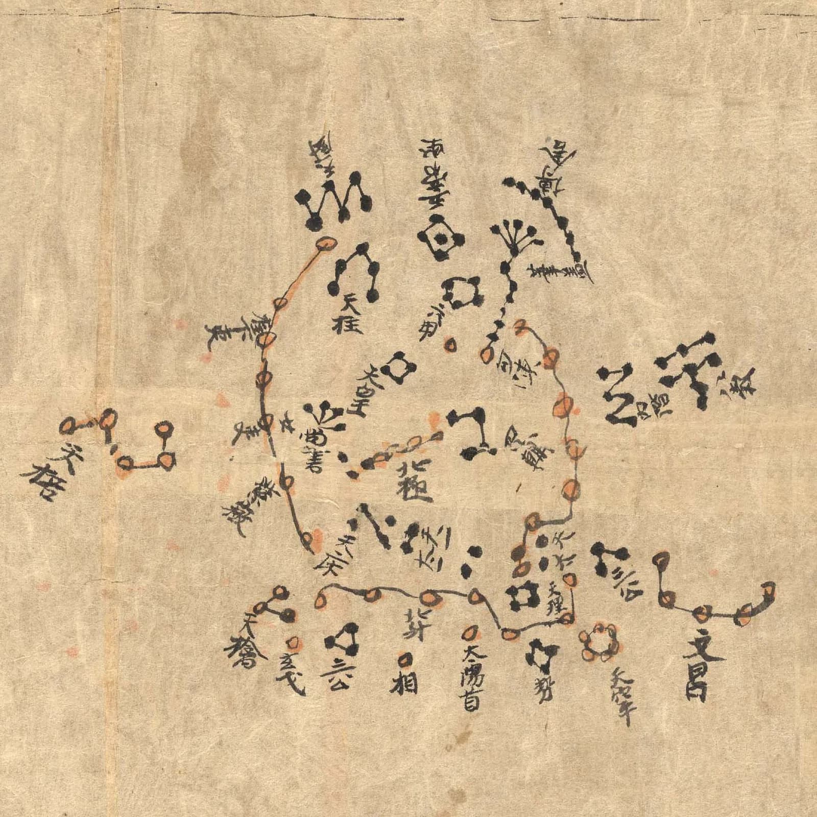
The paper is about 0.04 millimeters thick. Someone drew more than 1,300 stars on it in ink, in a row of maps that runs across a scroll.
Aurel Stein found the scroll in 1907 in a library cave near Dunhuang. The cave had been sealed for almost a thousand years.
The traditional view
The scroll is catalogued at the British Library as Or.8210/S.3326. Bonnet-Bidaud, Praderie and Whitfield write that Stein found it among a pile of at least 40,000 manuscripts in the Library Cave at Mogao. They call the atlas "the oldest complete preserved star atlas from any civilisation."
The first part of the scroll is a text on divination by clouds. The star atlas follows without a break. It holds 12 maps of the sky in strips and one circular map of the north polar region. The three authors count 1,339 stars in 257 asterisms. The International Dunhuang Programme counts 1,345 stars in the same 257 asterisms.
The authors measured the positions of the brightest stars against a modern sky. They report an accuracy of 1.5 to 4 degrees and conclude that "precise mathematical methods were used to produce the atlas."
They confirm the dates 649 to 684, the early Tang dynasty, as most probable. The IDP object record gives the same range. Its learning page says the atlas is probably from around 700 CE.
The authors find no earlier complete star atlas anywhere. They put the oldest true atlas in Europe at the Vienna manuscript of about 1440, some seven centuries later.
What The Sky Remembers
In Earthly Enigmas I treat the sky as a record. In Chapter 4 I write that "Precession was not officially discovered by Western science until Hipparchus in approximately 127 BCE." I also argue that encoding precession implies earlier astronomical knowledge.
In Chapter 5 the section called "The Same Sky, Everywhere" follows the same celestial events across sites in several countries. In Chapter 10 I close with the line "We are not progressing, we are recovering."
The Scroll Nobody Can Place
Both views lean on questions the evidence cannot yet answer. Three of them stand out.
What date does the scroll carry?
The authors read the date from several clues, and the clues do not all agree. The paper is similar to paper used in China up to and including the Tang dynasty. The scroll holds the taboo form of one character from the name of the emperor Taizong, which points to a date after 649. It holds the name character of the emperor Ruizong in its standard form, which points to a date before he took the throne in 684. They write that "This is fairly strong evidence that the manuscript dates from between 649-684."
Joseph Needham put the date at about 940 in 1959. The authors say his grounds are ones they "were unable to trace." Pan Nai proposed a tenth-century copy, which they say he did "without any further argument." Ma Shichang proposed about 705 to 710, and the authors say his argument "contains inconsistencies."
The sky on the scroll gives other answers. The authors fit the polar map and report a pole position consistent with a date around 650. The monthly texts at the foot of the maps point somewhere else. The authors calculate configurations between roughly 40 BCE and 220 CE. They write that this "indicates that the texts on the document may be a compilation of different sources."
Carbon dating "should be possible but has not been attempted yet," they write. Their paper appeared in 2009. I have not checked whether anyone has tested the scroll since.
When was the scroll made, and when was the sky it shows first measured?
Where are the atlases that came before it?
The authors write that "In China, before the Dunhuang map, only few objects give a graphical description of the sky and none of its totality." The oldest they name is a lacquer box from the tomb of the Marquis of Yi, dated to about 430 BCE. It lists the 28 lunar mansions around the Big Dipper "but with no other detail on the sky."
The closest comparison is a book of about 590 to 600 CE, the Bu Tian Ge. The authors say its sky illustrations cover only the mansions at the equator and the north polar region. They write that it is "by no means as complete and accurate as S.3326."
They describe the atlas as established "according to precise geometrical rules." They also write that it "appears therefore as a probable hand copy of a previous more accurate document."
The University of Chicago Press History of Cartography adds more. It says modern studies have suggested the middle of the third millennium BCE for the date the lunar mansions were first conceived. It then writes that "there is no evidence of an advanced culture in China at such a remote period." It says "there is no hint of the existence of star maps in the Zhou dynasty."
The same chapter reports that Yasukatsu Maeyama dated the star positions in the Kaiyuan Zhanjing to within a few decades either side of 70 BCE. It writes that evidence for detailed mapping by the early astronomers Shi Shen, Gan De and Wu Xian "rests on late traditions rather than on more tangible evidence." The chapter also allows that the measurements "represent revisions of more ancient observations that no longer survive."
The authors of the atlas study write that the star catalogues in Sima Qian's astronomical chapters are "copies of older, lost ones composed during the Warring States period." Both statements sit in the published literature.
Where are the atlases that came before it?
What was it for?
The scroll lacks its cover and its end. The authors ask "What could be the use of a star atlas just following this first section of the manuscript?" They answer "We can only make conjectures."
They raise the idea that it helped travelers or warriors on the Silk Road. They then write that "the high quality of the paper and the importance and sensitivity of the subject-matter argues against this."
The International Dunhuang Programme says that "the distribution of documents like this would have been strictly controlled and limited to military and governmental use." It adds that the chart seems likely to have been brought to Dunhuang by an official from the capital. The writer of the first section says, in Imre Galambos's translation, "My own experiments showed them to be reliable, this is why I recorded them."
The authors conclude that "It is a mystery and, unless we discover similar documents, we might never know its original purpose."
Who needed this scroll, and what did they do with it?
The questions I can't put down
Some questions need more room than one article gives them. Two of them keep pulling me back.
Where is the pole star? The circular map shows the north polar region as the seat of the emperor. The authors write that "for some reason the polar star is not shown on S.3326." Two asterisms in the polar region carry names the authors read as "indicating they were once polar stars." They ask whether the confusion there is a copying error, and they note a suggestion of "two different positions of the pole in the past." I have not read that suggestion in the original. In the book I argue that encoding precession implies earlier astronomical knowledge. I follow that question through Earthly Enigmas.
Why does Orion look familiar on a Chinese map? The authors single out the fifth map. They find "a rare case where a constellation seen by the ancient Chinese is similar to what we are used to in the Western world." In the book I follow Orion's Belt through Giza, Teotihuacan and the mounds at Xi'an, which I call "three cultures, three pyramid complexes, no documented contact." I also allow that coincidence is a legitimate explanation. The Giza article looks at the pyramids in detail. You can read a free sample of the book before you decide. The articles section has more subjects in the same format.
Sources
- Bonnet-Bidaud, Praderie and Whitfield, The Dunhuang Chinese Sky: A Comprehensive Study of the Oldest Known Star Atlas (Journal of Astronomical History and Heritage, 2009; arXiv:0906.3034)
- International Dunhuang Programme: Or.8210/S.3326 object record
- International Dunhuang Programme: The Dunhuang Star Atlas (Chinese Astronomy learning resource)
- Imre Galambos, Translation of the Dunhuang Star Chart (IDP, 2009)
- University of Chicago Press, History of Cartography, vol. 2, book 2, chapter 13: Chinese and Korean Star Maps and Catalogs (first 20 pages read)
- Wikipedia: Dunhuang Star Chart (secondary, used only to locate sources)