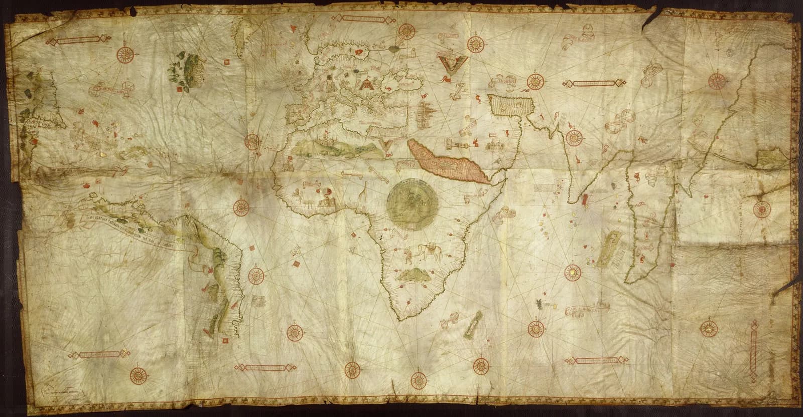
Ten sheets of vellum are joined into one chart that measures 115 by 225 centimeters. The Bibliothèque nationale de France catalogs it as a nautical planisphere signed Opus Nicolay de Caverio ianuensis.
The chart records Portuguese voyages to India and Brazil from the years just after 1500. The specialists I read agree that it drew on Portuguese material. They differ on which chart stood behind it.
The traditional view
The BnF catalog describes a manuscript on illuminated vellum. I translate from the French here. It gives the date as before 1506 in square brackets. A note says the chart can be dated to about 1506 because it mentions no discovery after that year.
The catalog says the Genoese mapmaker seems to have used Portuguese documents. It says the place names are essentially Portuguese and that many legends are in Spanish. It adds that a misreading gave the mapmaker the name Canerio until 1947.
The left edge carries a latitude scale from 55 degrees south to 70 degrees north. The catalog counts fifty-three flags. Twenty-one are Portuguese, eight are Spanish and twenty carry the crescent.
A CNRS and BnF video page says the chart shows the Portuguese ports of call along the route to the Indies. It says the chart "provided one of the oldest mappings of the east coast of Africa."
Gregory McIntosh has published widely on early charts and wrote a book on the Piri Reis map. In a short MEDEA-Chart piece he describes the source of the Caverio planisphere. He writes that it "was copied directly or indirectly from the Portuguese Padrão Real in Lisbon." He calls the Padrão Real "the regularly-updated master planisphere from which charts used onboard ships were made."
He reads it as "probably a younger 'sister' chart" to the Cantino planisphere of 1502. He says the Brazil coast records the Portuguese expedition of 1501 and 1502 led by Gonçalo Coelho, which included Amerigo Vespucci. He adds that Martin Waldseemüller "used the Caverio planisphere as a primary source" for his world maps of 1507 and 1516.
What the Chart Carries Forward
Chapter 5 of Earthly Enigmas makes an argument about maps. I treat the Piri Reis map as one correlation among several in my case for a global network. I read it as a compilation of older source maps. I write that someone, before 1513, had mapped the Atlantic coastlines with unusual accuracy. I also write that "None of this is possible without global knowledge."
The Caverio planisphere belongs to the same decade as the Piri Reis map. Like that map it draws on an older source chart. Whether it belongs in my argument is not something the book says. The Piri Reis article covers the chart that names its sources.
Where the Experts Part Ways
Both views lean on questions the evidence cannot yet answer. Three of them stand out.
Where is the chart they both came from?
Alida Metcalf of Rice University sets the Caverio chart beside the Cantino chart. She writes that many similarities suggest "that Caverio copied Carta del Cantino (or that both world charts shared a now lost prototype)." She notes that both charts have "virtually identical legends for Brazil and Calicut." She adds that both show the same error, "the unthinkable omission of the Nile River."
She also notes the differences. The Cantino chart has six skins and the Caverio chart has ten. Caverio "added geographic information that is not found on Carta del Cantino, such as more place names along the coast of Brazil."
In a 2022 paper in Terrae Incognitae McIntosh argues for the second reading. I read only the abstract, because the paper is behind a paywall. He writes that a "careful examination of the placenames on the coast of Africa" shows the Caverio chart "was probably not derived from the Cantino planisphere."
His abstract puts both charts in one family. He writes that the most likely explanation is a copy of the Padrão Real of about 1505 to 1506. The Cantino chart, he says, "reflects the cartography of the previous version of the Padrão Real of 1502."
A shared error also travels down a line of copies. Joaquim Alves Gaspar writes in Terrae Incognitae about the size of the Antilles. They appear at a "remarkably exaggerated scale relative to Europe" on the Cantino chart, the Caverio chart "and many other planispheres." He finds the first charts that fully corrected the mistake dated 1525.
None of the sources I read points to a surviving Padrão Real. I have not searched for one. Where is the chart that both of these came from?
Who drew the coasts first?
Roel Nicolai of Utrecht University studied the Cantino chart. He writes in Terrae Incognitae that its outline of Africa "is so good that it was not surpassed in the next two, possibly three centuries." He reads the African coast as "a mosaic of accurate regional charts on the plate-carrée projection."
He says the shape of these regional charts "was essentially correct on the oldest chart (c. 1471) and was copied to later charts." He also says their projective properties "are incompatible with the navigation and charting techniques used in that period." His conclusion is that "serious doubt is cast on the established view that Portuguese pilots and cartographers were the original creators of the source charts."
Gaspar reaches a different result on the same chart. His 2012 paper in Imago Mundi analyzes the Cantino chart. He concludes that its geometry "is fully explained by the use of the cartographic methods of the Renaissance" once the effect of magnetic declination is counted. I read that abstract only.
Both papers examine the Cantino chart. I have not checked whether either one ran the same analysis on the Caverio chart. McIntosh puts the two in one family, so the question carries over. Nicolai applies a similar argument to the Mediterranean charts, and I follow that in the Carte Pisane article.
Did Portuguese pilots draw the first versions of these coasts, or did they inherit them?
When and where was it made?
The BnF date is a ceiling. The catalog says about 1506 because no later discovery appears. That sets the latest date and leaves the earliest open.
The dates in print run across several years. McIntosh and the CNRS page say about 1505, and Metcalf says 1506. Gaspar calls it "the Caverio (c. 1504)." Patrick Shekleton, in an abstract for a slide deck on Academia, dates it to 1503.
Shekleton reads a tower in a bay on the Cantino chart at 39.33 degrees as evidence of the Newport Tower. He writes that the Caverio chart "illustrated a tower in the same bay (same toponym) but at a slightly lower latitude (38.50°)." I have read only his abstract and I have not checked his reading.
The place is open as well. The BnF gives no place of origin. MEDEA lists the country as "Portugal (or Italy)." Wikipedia says it was probably made in Lisbon by the Genoese Caveri, or copied by him in Genoa from a Portuguese map very similar to the Cantino map. I have not checked that statement in McIntosh's paper, which Wikipedia cites.
MEDEA lists a 1947 article by Paolo Revelli on Caveri as further reading. The BnF bibliography lists it too. I have not read it.
Which year was it drawn, and in which city?
The questions I can't put down
Some questions need more room than one article gives them. Two of them keep pulling me back.
What is the small world map doing in the middle of Africa? The BnF catalog says a small circular world map, ringed by the seven heavens, marks the center of the compass line system. It says the coasts on that map are more archaic than those of the planisphere. It says the map recalls one attributed to Christopher Columbus, which the library holds as Ge AA 562. I translate that from the French. In Chapter 5 of Earthly Enigmas I follow the Piri Reis map, a chart built from older charts.
How secret was the secret chart? A Khan Academy essay says the Cantino chart has long been called an illegal copy of an official chart. It says a letter by a Venetian living in Spain described giving foreigners news of discoveries as punishable by death. It adds that recent research suggests the chart was less dramatic to obtain. José María Moreno Madrid writes that control of such information was strict in theory and that "both leaks and contact occurred constantly." I have read only his abstract. In the book I write that none of this is possible without global knowledge, and you can read a free sample before you decide. The articles section has more subjects in the same format.
Sources
- BnF catalog: Planisphère nautique, Opus Nicolay de Caverio ianuensis (GE SH ARCH-1)
- BnF Gallica: digital copy of the chart
- CNRS Images and BnF: Nautical world map by Nicolas Caverio
- Gregory McIntosh, Chart of the Week: The Caverio Planisphere (MEDEA-Chart, 2021; Wayback Machine copy)
- Gregory McIntosh, The Caverio Planisphere (c. 1506) Was Not Copied from the Cantino Planisphere (1502), Terrae Incognitae 54 (2022), abstract
- Alida Metcalf, Nicolay de Caverio, Planisphère nautique, 1506 (Mapping an Atlantic World, Rice University)
- Roel Nicolai, The Mapping of Africa on the Nautical Charts of the Age of Discovery, Terrae Incognitae (2021), abstract
- Joaquim Alves Gaspar, Blunders, Errors and Entanglements, Imago Mundi 64 (2012), abstract
- Joaquim Alves Gaspar, The Representation of the West Indies in Early Iberian Cartography, Terrae Incognitae (2015), abstract
- Patrick Shekleton, 1502 Cantino Planisphere, Cartographic Evidence of the Pre-Columbian Newport Tower (Academia, abstract only)
- Rachel Zimmerman, The Cantino Planisphere (Khan Academy)
- José María Moreno Madrid, Circulation and Contacts in Sixteenth Century New Cartography (2021), abstract
- Wikipedia: Caverio map (secondary, used to locate McIntosh and Gaspar and for the Lisbon or Genoa statement)