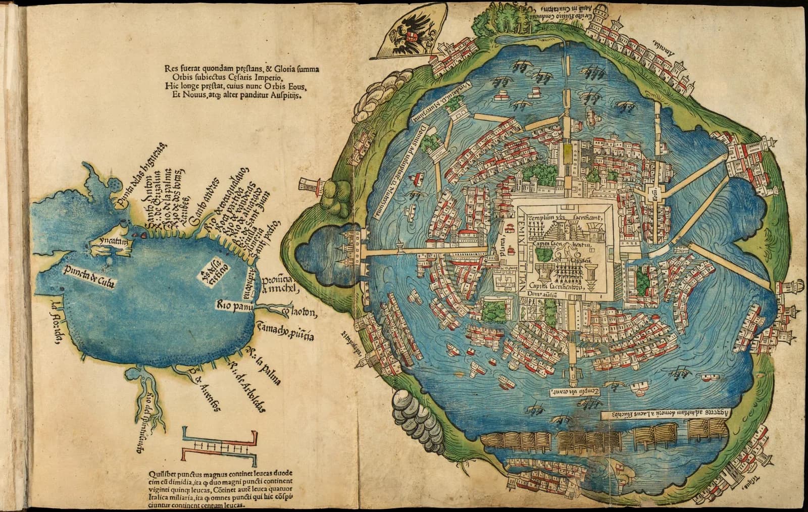
In February 1524 a printer in Nuremberg published a folded woodcut of an island city. The label near the middle read Temixtitan.
The city it showed had been in ruins for about two and a half years.
The traditional view
The plan appeared in the first Latin edition of Hernán Cortés's Second Letter to Emperor Charles V. The Library of Congress record says Friedrich Peypus printed it in Nuremberg in 1524 and Pietro Savorgnano translated it. Cortés dated the letter October 30, 1520.
The record calls it the first published plan of the Aztec city and says it "depicts the city in that year." It says the plan is "oriented with west at the top." At the center sits a square ritual area with a stepped pyramid temple marked Templum ubi Sacrificant. Wide causeways join the island to the shore.
A map of the Gulf coast sits beside the plan on the same sheet. The Library of Congress copy comes from the Newberry Library in Chicago and is hand colored.
Barbara Mundy writes that the woodcut "is undoubtedly carved by a European craftsman." Elizabeth Hill Boone agrees that a Nuremberg woodcutter "Europeanized the features of the plan." She points to the domed towers and to a dike drawn like a woven fence.
Cortés wrote his own description of the city. In the MacNutt translation he says "The city is as large as Seville or Cordoba." The Spanish printing of the letter in 1522 had no map, according to Mundy. The Nuremberg edition was the first to carry one.
Mundy adds that the city on the plan was gone by the time the plan was printed. She says it had been reduced to rubble by August 1521. She also writes that "we know of no map of Tenochtitlan that survived the conquest."
Daniel Astorga-Poblete reads the print differently in a 2025 chapter. His abstract calls it "a geographic and symbolic instrument to assert Habsburg authority" at the Diet of Nuremberg. I have only seen the abstract.
What the Evidence Leaves Open
The plan is a copy of something. The scholars agree on that much and disagree on what the something was.
Mundy argues that a Mexica map of the city lies behind the woodcut. She writes that "close examination reveals many precise details of the Amerindian city that do not appear in the long description" in the Second Letter. Her examples include the location of the Tlatelolco market, the source of the city's water at Chapultepec and the dike.
Boone supports that reading. She writes "I agree with Mundy that an indigenous hand was at work on the prototype for the plan." She adds a limit. The source of the woodcut, she says, "could not have been an unadulterated and unmediated indigenous map."
The older view differs. Mundy reports that Benjamin Keen thought the plan came from an eyewitness sketch sent by Cortés. Keen found the style conventional for European island cities. Manuel Toussaint thought a fellow conquistador trained as a pilot or surveyor drew it.
In Earthly Enigmas I ask a similar question in two places. In Chapter 5 I write that someone before 1513 mapped the Atlantic coastlines with unusual accuracy from older source maps. In Chapter 18 I write that the revised Maya population estimates are now mainstream.
The Prototype Nobody Has Seen
Both views lean on questions the evidence cannot yet answer. Three of them stand out.
Whose hand drew the city?
Mundy states that "The source of this woodcut map is unknown." Her case rests on content. She argues that a conquistador would have drawn the precinct on the scale the Spanish found overwhelming.
Boone gives a test. She writes that "It is highly unlikely that a Spanish draftsman would have specified the precise alignment of the Templo Mayor." The plan shows the face of the sun between the twin temples. Boone then admits that the Spaniards could have seen the equinox sunrise there in March 1520. She also says they could easily have visited Moctezuma's island pleasure house.
Mundy notes that Cortés "says nothing about the authorship of the city map." Peter Martyr, writing from Spain, describes "a native painting representing the town of Temistitan, with its temples, bridges, and lakes." Mundy reads that as support for a native source.
A European cut the block. Whose hand drew the city that he copied?
How did the drawing reach Nuremberg?
The dates leave gaps. Cortés dated the Second Letter 1520. The Spanish edition came out in 1522 without a map. The Latin edition with the plan came out in February 1524.
In the Third Letter of May 1522 Cortés mentions a dike "as Your Majesty may see from the map of the city of Temixtitan I have sent." He does not say which letter carried it. Boone writes that he "probably sent the plan with his second letter." Mundy writes that he sent it to accompany the Second Letter and cites the Pagden translation. In the MacNutt translation I read, the sentence sits in the Third Letter. I have not seen Pagden.
Martyr says he saw a painting of the city in Seville. Mundy notes that this "is inconsistent" with Cortés's account of a map sent in 1520. She suggests that copies reached Charles V in Germany and stayed with his brother Ferdinand, who spent much of 1522 to 1524 at the Diet in Nuremberg. She writes "We can speculate on their travels."
I have not found any record of the person who handed a drawing to the printer. What path did it take from Mexico to Nuremberg?
Is it a survey or a picture of an idea?
The plan puts the city in the middle of a round lake. Mundy writes that this is "clearly contradicting the actual planimetry" of the linked lakes, and she notes that Cortés knew there were two. Boone says the plan compresses the lakes into one body and pulls distant features toward the center.
Mundy reads the circles as a Mexica habit of drawing the capital at the center of the world. She points to the Lienzo de Tlaxcala and other native pictures that show the city on a circular island. Keen read the same style as the usual European way of drawing island cities. Mundy concedes that the engraver "may have had maps of Venice on his mind."
The temple precinct is drawn small. Mundy reports that the friar Sahagún's informants described at least seventy-eight structures there. Cortés wrote of a precinct big enough for five hundred houses. Mundy reads the plan's few buildings as "a conscious choice" that reduces the precinct to a symbol.
What was the original drawing meant to record, the place or an idea of the place?
The questions I can't put down
Some questions need more room than one article gives them. Two of them keep pulling me back.
How big was the city? Cortés compares it to Seville or Cordoba and gives no count of people. MacNutt's 1908 note says the earlier writers support a figure of not less than 300,000. Eloy Jiménez Martínez compares densities in a 2022 article. By my translation of the Spanish abstract, he concludes that between 75,000 and 95,000 people lived there in 1519. In the book I write about population estimates that moved for the Maya. I follow that question through Earthly Enigmas.
What else was on the cloth Martyr saw? He describes a map thirty feet long, painted on white cotton, that showed the plains and provinces around the valley. No copy of it survives. In the book I ask where the older source maps behind the Piri Reis map went, and the Piri Reis article follows that question. You can read a free sample before you decide. The articles section has more subjects in the same format.
Sources
- Library of Congress: Second Letter of Hernán Cortés (Nuremberg, 1524), record 2021667098
- Barbara E. Mundy, Mapping the Aztec Capital: The 1524 Nuremberg Map of Tenochtitlan, Its Sources and Meanings, Imago Mundi 50 (1998)
- Elizabeth Hill Boone, This new world now revealed: Hernán Cortés and the presentation of Mexico to Europe, Word & Image 27:1 (2011) (read from a PDF mirror)
- Francis A. MacNutt, trans., Letters of Cortés, vol. 1 (1908)
- Francis A. MacNutt, trans., Letters of Cortés, vol. 2 (1908)
- Peter Martyr d'Anghiera, De Orbe Novo, trans. MacNutt, vol. 2 (1912)
- Eloy Jiménez Martínez, En torno a la población de México-Tenochtitlan en 1519, Anuario de Historia Regional y de las Fronteras 27:1 (2022) (abstract only)
- Daniel Astorga-Poblete, The Plan of Tenochtitlan and the Symbolic Dominance of the Holy Roman Empire During the Diet of Nuremberg (1524), Springer (2025) (abstract only, not cited above)