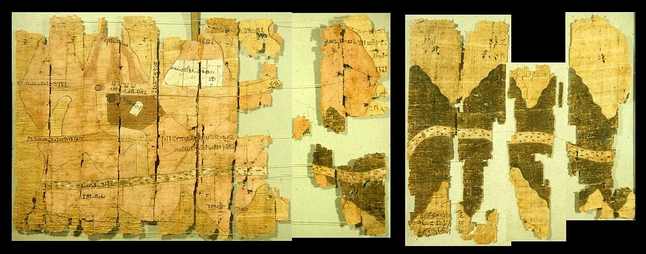
A papyrus scroll in Turin shows about 15 kilometers of a desert valley in Egypt. The hills are drawn in pink and black. The gravel on the valley floor is drawn as dots in brown, white and green.
The geologist James Harrell says those are more or less the colors of the real gravel.
The traditional view
The Museo Egizio dates the scroll to 1155 to 1150 BCE, in the Twentieth Dynasty under Ramesses IV. It measures 2820 by 410 millimeters. Agents of the collector Bernardino Drovetti found it between 1814 and 1821 and it reached the museum in 1824. Harrell writes that it came from a private tomb in the workmen's village of Deir el-Medina.
The scroll shows a stretch of Wadi Hammamat, a dry valley that links the Nile Valley to the Red Sea. The top of the map points south. Harrell writes that there is "no constant scale used on the map," although it runs between 50 and 100 meters for each centimeter.
The museum says the scribe Amennakht, son of Ipuy, owned it and is believed to be its author. Harrell goes further and writes that "it is clear that he is its author," because the handwriting matches his other work.
Harrell writes that the map was prepared for a quarrying expedition sent by Ramesses IV. The aim was to cut blocks of bekhen-stone, a grayish-green stone the Egyptians prized for statues. He reports that the king's rock inscription records 8,362 men on that expedition. I have not read the inscription.
Harrell calls the scroll "the oldest known geologic map in the world." He adds that it would be another 2900 years before the next one, which was made in France in the mid-1700s.
The scroll is broken. Harrell writes that the museum's arrangement of the pieces, which dates to the early 1900s, "is incorrect in several of its details." His rearrangement shortens the map to about 210 centimeters, and he says an unknown amount has been lost at the right edge.
The back of the papyrus carries more than a dozen other texts. Harrell explains that papyrus was expensive and scribes reused the blank side once the front was no longer needed.
What the Evidence Does Not Settle
The specialists read the scroll in two main ways.
In the first reading it is a working record of a stone and gold landscape. The museum's own database record says the pink mountains "indicated the presence of granite and gold deposits" and the dark brown ones "contained sedimentary rock." It adds that the wadis "are represented as roads on the papyrus."
In the second reading it is a commemoration. Archaeology magazine reports that, according to Andreas Dorn and Stéphane Polis, "No map would have been needed for general travel." The magazine describes the scroll as a "commemorative record of a pharaonic expedition." Harrell reaches a similar view, that it was "most likely" a "visual record of the expedition."
What the Scroll Cannot Say
Both readings lean on questions the evidence cannot yet answer. Three of them stand out.
What was the map for?
Harrell writes that the map was almost certainly made for the big expedition of Ramesses IV, "but what purpose it served is unclear." He says it could not have been a road map to the quarry. It leaves out the 75 kilometers between Wadi Hammamat and the Nile Valley.
Dorn has a different concern. He says the old nickname "Goldmine Papyrus" is a good name from a marketing point of view, but "it completely ignores the main action that was documented: the transport of Bekhen stone." Harrell tells reporter Peter Hessler that the annotations say things like "hills where gold is found" and "hills of gold and silver."
Harrell also says nobody knows why Amennakhte kept the map once the expedition was over. What was the scroll for, and why did the scribe hold on to it?
Did the scribe set out to draw geology?
Harrell writes that the papyrus "accurately shows the geographic distribution of different rock types." He points to a caption that "reads very much like a legend on modern geologic maps," explaining what the pink color means. Polis says the document "mixes geographical and geological information in a way that anticipates many of our modern mapmaking practices."
Harrell also writes that "there is no reason to think, however, that the ancient author intentionally set out to make a geologic map." In his words the scribe "merely drew what he literally saw in the desert." Hessler reports that Harrell calls it wrong to describe Amennakhte as a geologist, because nothing shows he approached the subject as a science.
The sources do not even agree on what the colors stand for. The museum's database says pink is granite and gold and dark brown is sedimentary rock. The museum's collection record says pink with brown bands is sedimentary rock and pink granite, and black is "effusive and metamorphic rocks." Harrell reads the black hills as Hammamat siliciclastic rocks and the pink ones as volcanics, serpentinite and granite.
Is a map that matches the rocks without meaning to still a geological map?
Why is there only one?
Harrell calls the scroll the only topographic map to survive from ancient Egypt. He says older maps from outside Egypt are "all quite crude and rather abstract." Hessler tells readers that Harrell sees no known contemporary equivalent.
Hessler also reports that other maps were likely made in pharaonic times. He writes that such documents were typically not placed in tombs and that papyrus rarely survives for millennia. Harrell writes that Drovetti obtained the scroll from the family tomb of Amennakhte.
The Babylonian Map of the World is a clay tablet made centuries later that draws the world as a disc. The Tabula Peutingeriana shows a road system as a long ribbon. Each one is a different kind of map.
Is the Turin map the only one of its kind, or only the one that survived?
The questions I can't put down
Some questions need more room than one article gives them. Two of them keep pulling me back.
A second Turin papyrus matters here. The Turin King List is a different scroll, catalogued as Cat. 1874 and dated by the museum to 1279 to 1213 BCE. In the book I write that it begins with Neteru and Shemsu Hor and that the mainstream treats those early entries as mythological. I have not checked the contents of the list for this article. In Chapter 11 I ask whether the priests' Zep Tepi claim was mythological or historical, and I call that "precisely the question this book has been building toward." I follow that question through Earthly Enigmas.
How do you move that much stone? Harrell reports 8,362 men on the quarrying expedition the map was made for. In Earthly Enigmas I ask how large stones were moved, at Carnac and at Giza. The Pyramids of Giza article asks it about a pyramid. You can read a free sample of the book before you decide. The articles section has more subjects in the same format.
Sources
- James A. Harrell, Turin Papyrus Map from Ancient Egypt (University of Toledo)
- Museo Egizio collection record: Goldmine Papyrus, Cat. 1879 and joined fragments
- Museo Egizio papyrus database: The Turin Mine Map, document 9
- Museo Egizio: Andreas Dorn, The stories of the oldest geological map of mankind (2024 lecture page)
- Museo Egizio collection record: Turin King List, Cat. 1874
- Jarrett A. Lobell, Mapping the Past: The Goldmine Papyrus, Archaeology, May/June 2019 (secondary, for the words of Dorn and Polis)
- Peter Hessler, World's First Geologic Map Was Far Ahead of Its Time, National Geographic (2016) (secondary, for Harrell's spoken remarks)
- Harrell and Brown, The Journal of Geology 100 (1992) 3-18, and JARCE 29 (1992) 81-105 (cited by Harrell and by the museum; I have not read either paper)
- Wikipedia, Turin Papyrus Map (used only to locate sources; no fact is taken from it)