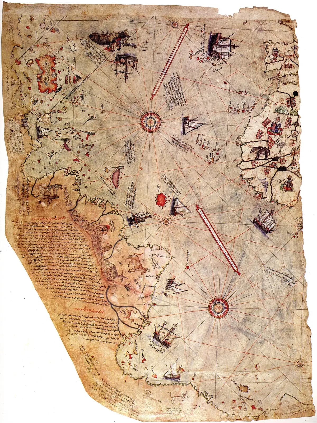
In 1929 scholars working in the archives of the Topkapı Palace in Istanbul found part of a map. It was dated 1513, only 21 years after Columbus reached America. A note on it said that the coasts and islands were taken from Columbus's map.
People have argued about the southern coast ever since. I keep asking where the maps behind it went.
The traditional view
An Ottoman captain named Piri Reis drew the map. UNESCO lists the surviving fragment in its Memory of the World register. It calls the map the earliest cartographic record of Columbus's voyages. It describes a detailed and considerably accurate picture of the newly discovered regions. It adds that fixing the position of new places was almost technically impossible at the time.
Piri Reis wrote on the map that he drew it from about twenty charts and mappae mundi. Gregory McIntosh wrote a book-length study of the map and finds it ordinary for its time. He writes that it "is not the most accurate map of the sixteenth century, as has been claimed."
On the southern coast McIntosh sees Terra Australis. This was the southern continent that geographers of the period expected to find. He notes that a Portuguese map from about 1519 to 1521 and a Spanish map of 1524 also join South America to it.
Knowledge of the Entire Globe
In Earthly Enigmas I treat the Piri Reis map as one correlation among several in my argument that a global network needed global knowledge. I read it as a compilation of older source maps drawn with unusual accuracy.
Charles Hapgood argued in 1966 that the southern coast shows Antarctica before the ice. The mainstream reads that land as a distorted South America. I say the debate remains open.
What Has Not Been Explained
Both views lean on questions the evidence cannot yet answer. Three of them stand out.
Where are the source maps?
Piri Reis lists his sources on the map itself. McIntosh translates the inscription as saying the map was completed "from about twenty charts and mappae-mundi." They include eight maps he calls Jaferyas, an Arabic map of India and four Portuguese maps. Columbus's map is the last on the list.
Scholars do not agree on the total. Some count twenty, some thirty and some thirty-four.
In 1980 Paul Hoye and Paul Lunde wrote in Saudi Aramco World about the Hapgood question. They said settling it would take the location of at least one source map. Hapgood replied that no search for the source maps had ever been made.
If he had twenty maps to work from, where are they?
What is the land at the bottom?
Below the Rio de la Plata the coast of South America turns east and runs along the foot of the map. Several readings of that coast sit side by side.
McIntosh reads it as Terra Australis joined to South America, as other maps of the period show it. According to the Wikipedia article on the map, the cartographic historian Svat Soucek noted that the parchment curves at South America. He added that cartographers often adjusted the orientation of a coastline to fit the surface available. I have not checked that quotation in Soucek's own work.
Hoye and Lunde say the resemblance to the Antarctic coast is slight. They add that if the section ran south instead of east it would look much more like the east coast of South America. They say some of its features "jibe remarkably well" with a modern map of South America.
Hapgood's team took the other side. Hoye and Lunde summarize their case this way. They saw the Andes and a llama on the map. They saw a feature that looked like the Falkland Islands. They concluded that the land south of it was Queen Maud Land in Antarctica and that the match was "a striking similarity" accurate to within 20 miles. They also pointed to a 1949 seismic profile of Queen Maud Land that showed undersea mountains. Hoye and Lunde report that Hapgood accepted his cartographers had lost 900 miles of South American coast. I have not read Hapgood's own text.
The same Wikipedia article reports that the geologist Paul Heinrich objects. He says the match confuses the land under the ice with a hypothetical ice-free Antarctica, because it leaves out the way land rises after ice melts. He also says the 1949 survey measured under one percent of the area drawn on the map. I have not read Heinrich's own paper.
The ice itself is part of the argument. The same article says Hapgood believed Antarctica was free of ice in 17,000 BCE and partly free as late as 4,000 BCE. The British Antarctic Survey's education site says Antarctic glaciers began to form in the late Eocene, perhaps as much as 38 million years ago. Antarctica was first sighted in 1820, about three centuries after the map. A timeline from the Royal Museums Greenwich gives that date.
What did Piri Reis think he was drawing?
What did he mean by the days of Alexander?
In his inscription Piri Reis says his charts were drawn "in the days of Iskender dhu-l Karnian" and that they show "the inhabited quarter of the world." He adds that the Arabs call these charts Jaferya.
McIntosh reads Jaferya as a misspelling of the word for Ptolemy's Geography. On that reading the maps are medieval and Renaissance copies that go back to the second century CE. Hoye and Lunde ask whether that is what Piri Reis meant by maps drawn in the time of Alexander the Great.
How far back do his own words reach?
The questions I can't put down
Some questions need more room than one article gives them. Two of them keep pulling me back.
How did the distances come out so well? UNESCO calls the chart considerably accurate for a time when positioning new places was almost technically impossible. McIntosh says many later sixteenth century maps surpass it. Hoye and Lunde report Hapgood's claim that the map is accurate even in longitude, which mariners and mapmakers could not calculate until spherical trigonometry arrived. I follow what that means for global knowledge in Earthly Enigmas.
What else is in the archive? The map came to light in 1929 when scholars searched the Topkapı archives. The Wikipedia article reports, citing Gerber (2010), that the museum director gave a visiting scholar access to rooms nobody had opened and that undocumented manuscripts turned up. Hapgood said nobody had searched for the source maps. I have not checked Gerber. You can read a free sample of the book before you decide. The articles section has more subjects in the same format.
Sources
- UNESCO Memory of the World: The Piri Reis World Map (1513)
- Gregory McIntosh, The Piri Reis Map of 1513 (University of Georgia Press, 2000)
- Paul Hoye and Paul Lunde, Piri Reis and the Hapgood Hypotheses, Saudi Aramco World (1980)
- Royal Museums Greenwich: History of Antarctic explorers
- British Antarctic Survey: Tectonic history, into the deep freeze
- Wikipedia: Piri Reis map (secondary, for the Soucek, Heinrich, Hapgood dates and Gerber points)