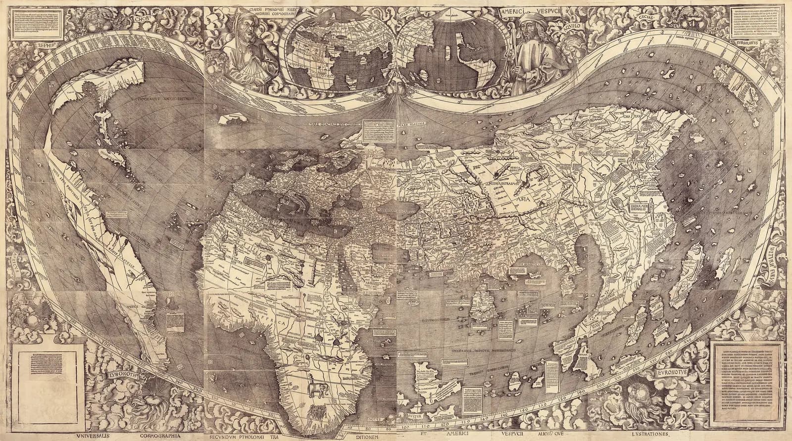
Twelve printed sheets join into a wall map about 128 by 233 centimeters. The Library of Congress holds the only known copy.
The map is famous for one word, because it is the first to print the name America. The part that keeps pulling me back is the water along its left edge.
The traditional view
Martin Waldseemüller made the map in 1507 with his colleague Matthias Ringmann at Saint-Dié in Lorraine. Chet Van Duzer writes that the pair published three works "designed to accompany each other." They were a short book, a set of globe gores and the wall map. Van Duzer translates the map's title as "A map of the whole world according to the tradition of Ptolemy and the explorations of Amerigo Vespucci and others."
The Library of Congress says this is "the only known surviving copy of the 1,000 maps that are believed to have been printed." The Jesuit historian Joseph Fischer found it in 1901 at Wolfegg Castle, bound into a volume made by the globe maker Johannes Schöner. The Library completed its purchase in 2003.
The name comes from the small book. In the 1907 English translation by Edward Burke the passage reads, "I see no reason why any one should justly object to calling this part Amerige, i.e., the land of Amerigo, or America, after Amerigo, its discoverer, a man of great ability." The same book says the fourth part of the world "is an island, inasmuch as it is found to be surrounded on all sides by the ocean."
Toby Lester, in a popular history adapted for Smithsonian Magazine, argues that Ringmann wrote the book and most likely coined the name. The Library credits both men.
Van Duzer finds that the map follows older models. He writes that its design, projection and long texts are "based closely on the large world map by Henricus Martellus at Yale, which was made c. 1491." He means another similar Martellus map that is now lost. He adds that "we know that Waldseemüller had access to the Caverio map when he made his 1507 map." The map is also built on Ptolemy, the second-century geographer, and on the voyages of Columbus and Vespucci.
The Ocean Before Balboa
Chapter 5 of Earthly Enigmas makes an argument about maps. I treat the Piri Reis map as one correlation among several in my case for a global network. I write that someone, before 1513, had mapped the Atlantic coastlines with unusual accuracy. I also write that "None of this is possible without global knowledge."
The Waldseemüller map is six years older than the Piri Reis map. The Library of Congress says it shows the new land as a separate continent beside a separate ocean. Whether it belongs in my argument is not something the book says. The Piri Reis article covers the chart that names its own sources.
Where the Experts Part Ways
Both views lean on questions the evidence cannot yet answer. Three of them stand out.
What did the mapmaker know about the ocean on the left?
The Library of Congress puts the problem in its own words. It says the map is "the first known map to show the Continent of South America separated from Asia in a way that reveals the existence of the Pacific Ocean." It adds that "neither Magellan nor Balboa had reached the Pacific Ocean by this time."
A second Library page goes further. It says the Pacific and the western coast of South America on the map "remains an unsolved mystery for scholars." It asks, "How then did Waldseemüller know of the ocean's existence and depict a continent whose coastline on the west borders the ocean?"
John Hébert, chief of the Library's Geography and Map Division, was asked on NPR whether the mapmaker was guessing well. He answered, "obviously, someone had been here." He also said, "But we don't know and we're still trying to put that story together." The page is dated 2001, but it describes the 2007 handover of the map, and I have not resolved the date.
John Hessler of the Library told the Washington Post that "There is some probability that Waldseemueller knew something that is no longer extant." I read the first page of that article only.
Van Duzer's account is a different kind of answer. He writes that the map "represents all 360 degrees of longitude at a time when the interior and the western reaches of the New World were unknown, and the vastness of the Pacific was still undiscovered by Europeans." He treats that as a bold design choice. His chapter does not discuss the outline of the western coast, and I found no source that does.
Two further views reach me secondhand. Wikipedia says the historian Peter Whitfield has theorized that Waldseemüller reasoned from Vespucci's accounts that the new lands could not be part of Asia. Robert Finlay, in a critical review, reports that Gavin Menzies asserts Chinese charts stand behind the Waldseemüller maps. I have not checked Whitfield and I have not read Menzies.
What did the mapmaker know about the ocean on the left?
How did the information reach a village in Lorraine?
The Library's 2009 bulletin says that how news of the Columbus and Vespucci voyages "arrived in the village of St. Dié in the early 16th century remains an open and controversial question." The Library's exhibit says the sources for the New World "remain unknown to scholars."
The mapmaker names one kind of source himself. In the 1907 translation he writes that in designing the sheets "on the marine charts we observe that the equator is placed otherwise than Ptolemy represented it." The introduction to that volume, written in the voice of Fischer and Franz von Wieser, says "We can prove positively that Waldseemüller made use of two Portuguese sea-charts."
One of those charts may be known. The same introduction says the "principal cartographic source" was the Caverio chart, which it spells Canerio. It says the agreement is so close "that it could not have been a map of the Canerio type" but "must have been Canerio's map itself." Van Duzer says the mapmaker had access to the chart, and Gregory McIntosh calls it a primary source. The Caverio article sets out what the specialists say about that chart. It also asks where the older chart behind it went. I have not checked what the Caverio chart shows west of South America, so I cannot say how much of the ocean it explains.
Some of the trail is lost or contested. Van Duzer, according to the Library's bulletin, postulated a lost cartographic source for the map by tracing its sea monster legends. Lester writes that the Vespucci letter that reached Duke René of Lorraine was "also falsified." I did not look into who wrote Vespucci's letters, and I cannot say how settled that point is.
How did the news reach Saint-Dié, and what else came with it?
Why did the later map know less?
Waldseemüller made a second large world map in 1516. The Library describes the Carta Marina as "markedly superior to the earlier map in artistic detail" and says it uses "greatly expanded and corrected geographical information."
The same Library pages describe what it leaves out. Waldseemüller "omits the word" America from it, and "indicates that North America is joined with Asia." The Library says he dropped the name "in part because of the controversies surrounding his earlier naming." A comparison page adds that "The size of South America is greatly reduced" and that he "no longer shows a Pacific Ocean."
Van Duzer reads the later choice as caution. He writes that the mapmaker "more prudently omits as unknown everything between the eastern coast of the New World and the eastern coast of mainland Asia." He also notes that the Caverio chart shows parts of the ocean now called the Pacific that Waldseemüller "chose not to copy."
The man who drew the ocean in 1507 left it off nine years later. Why did the better informed map know less about the west?
The questions I can't put down
Some questions need more room than one article gives them. Two of them keep pulling me back.
How does a printing of a thousand maps end at one? Lester writes that "copies of the 1507 map wore out or were discarded in favor of more up-to-date and better-printed maps." The Library's bulletin adds that S. Blair Hedges dated the surviving copy to about 1515, which means the woodblocks lasted at least ten years. Nothing I read says the map was suppressed. In Chapter 16 of Earthly Enigmas I follow how records disappear in other cases, including the Mesoamerican codices.
Why does a map of the newest discoveries carry the oldest legends? Van Duzer writes that its sea monster texts come "from medieval sources," and that they suggest the mapmaker "still saw the ocean as dangerous." The map joins those texts to Ptolemy and to recent voyages. In Chapter 5 I follow the Piri Reis map, which names about twenty older charts behind it, and you can read a free sample before you decide. The articles section has more subjects in the same format.
Sources
- Library of Congress: Waldseemüller Maps, Exploring the Early Americas (home)
- Library of Congress: 1507 World Map
- Library of Congress: 1507 World Map Highlights
- Library of Congress: Carta Marina 1516
- Library of Congress: 1507 and 1516 compared
- Library of Congress Information Bulletin, July/August 2009: Exploring Waldseemüller's World
- Library of Congress item record (the page blocks automated readers; not read)
- Waldseemüller, Cosmographiae Introductio, facsimile and English translation by Edward Burke, with Joseph Fischer's introduction (1907)
- Chet Van Duzer, Introduction to the Carta Marina (Springer, 2020)
- Chet Van Duzer, Changing Ideas about the Oceans Reflected in the World Maps of Martin Waldseemüller (Terra Brasilis, 2019; Wayback copy)
- Toby Lester, The Waldseemüller Map: Charting the New World (Smithsonian Magazine; popular history)
- NPR, All Things Considered: interview with John Hébert (transcript)
- David Brown, 16th-Century Mapmaker Martin Waldseemueller's Intriguing Knowledge (Washington Post, 2008; Wayback copy, first page only)
- Robert Finlay, How Not to (Re)Write World History: Gavin Menzies and the Chinese Discovery of America (review; used only to report Menzies's claim)
- Wikipedia: Waldseemüller map (secondary; used to locate sources and for the Whitfield statement, which I have not checked)