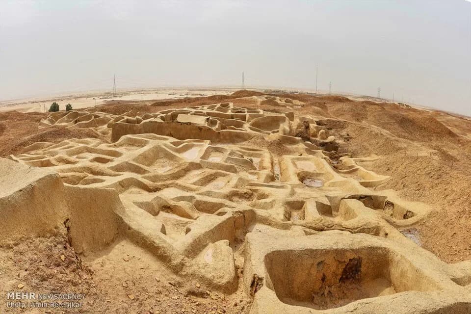
A low hill rises 19 meters out of the desert in southeastern Iran. ICOMOS puts the city on it at 151 hectares inside the boundary, about 2,220 meters long.
Local people named the place Shahr-i Sokhta, which means Burnt City. The specialists still disagree about when the city ended and what ended it.
The traditional view
UNESCO inscribed Shahr-i Sokhta in 2014. It says the city lies "at the junction of Bronze Age trade routes crossing the Iranian plateau" and that it was "founded around 3200 BCE" and "populated during four main periods up to 1800 BCE."
The same text lists a monumental area, residential areas, industrial zones and a graveyard. UNESCO says "changes in water courses and climate change led to the eventual abandonment of the city in the early second millennium."
The ICOMOS evaluation gives the four periods. Period I runs from 3200 to 2800 BCE and covers 16 hectares. Period II reaches "its largest size of 80 ha." Period III, from 2500 to 2300 BCE, is "a relatively unknown period due to lack of investigation." Period IV runs to about 1850 BCE and includes the Burnt Building, after which "the site was abandoned."
ICOMOS also reports lapis lazuli workshops in the north-western corner of the city. It says a comparison with lapis from the Royal Cemetery at Ur "indicates that the Shahr-i Sokhta workshops supplied the stone obtained from Badakhshan in a semi-finished state to Mesopotamia."
Italian teams excavated from the 1960s, working with the Iranian Centre for Archaeological Research. ICOMOS says the work broke off after the Islamic Revolution and resumed in 1997 under an Iranian program.
ICOMOS advised against inscription at that stage. It wrote that "it is clear that Shahr-i Sokhta was a very large and important city within south-eastern Iran." It did not consider that the site "stands out in relation to comparable sites in the wider region beyond south-eastern Iran." UNESCO lists the site under criteria (ii), (iii) and (iv). I have not read the Committee's decision.
The City in the Middle
In Earthly Enigmas I write that the common timeline begins with Mesopotamia. I also write that history books treat the ancient world as a series of isolated experiments. I argue for a network that links cultures with no documented contact. Among the 17 sites on Jim Alison's great circle I list Persepolis and Mohenjo-Daro.
ICOMOS places the city "between two of the most important civilisations of the third millennium BCE." It names the Mesopotamians and the Elamites in the west and the Indus Valley civilization in the east.
What the Record Leaves Open
Both views lean on questions the evidence cannot yet answer. Three of them stand out.
Did a fire end the city?
ICOMOS writes that the name comes from "traces of ash and fire." It describes the Burnt Building, with 25 rooms, as "destroyed by fire as indicated by the name."
UNESCO gives a different cause for the end of the city, which is water and climate. The excavation volume published in 2022 holds two further accounts.
Pier Francesco Fabbri and Giorgia Vincenti write that "life in the settlement abruptly ceased." They say the crisis behind it was attributed "not without uncertainty, to radical and sudden climate change."
Enrico Ascalone excavated Area 33 in 2018 and 2019. He writes of "a slow and inexorable decline around 2450 BC." He places the final abandonment around 2300 BC, "the causes of which remain unresolved." He says the drastic crisis that Maurizio Tosi proposed "can be ruled out."
Hossein Moradi and colleagues write that the Burnt Building "was occupied for a short time after the fire around 2000 BC." Ascalone describes the same area as briefly reoccupied around 2100 BC.
Moradi and colleagues add that the 1800 BC date for the building's last phase "casts doubt on the accuracy of the dates of this phase." Ascalone writes of "the raising by ca. 5 centuries of the chronology of Shahr-i Sokhta."
Wikipedia says that Massimo Vidale described the city in a 2021 lecture as burned down three times before it was abandoned. I have not checked the lecture.
Which came first, the fire or the abandonment, and what ended the city?
How many people lived here?
ICOMOS lists a different size for each period. Period II reaches 80 hectares and Period III falls to 20. Fabbri and Vincenti place the city's "maximum extension" in Phase 3 of Period III. They call it one of the largest settlements in the entire Near and Middle East.
Wikipedia, citing a chapter by Ascalone and Fabbri, says the estimate of the city's area has risen from 151 to 200 hectares. I have not read the chapter.
The graveyard adds a second set of numbers. Ratko Krvavac writes that it holds "at least 20,000 and possibly more than 40,000 burials." His note lists 18,000, 20,000 and 25,000 to 40,000 from three earlier authors. ICOMOS gives "20,000-37,000 graves, of which 680 have been excavated." Krvavac writes that over 1,000 graves have been excavated since 1972.
The graveyard holds the remains of people who lived in the city. I give the figures with that in mind and I draw no population from them.
How many people lived at Shahr-i Sokhta at one time, and how many over the life of the city?
Who was it trading with, and when?
UNESCO says its civilization "entertained trade and cultural relations" with the Indus plain, the Persian Gulf, the Oman Sea, southwest Iran and Central Asia.
ICOMOS answers that there is "very little evidence in the nomination dossier to support this conclusion." It reports that the excavators' published reports "conclude that the trade was not large-scale." They consider the evidence to suggest "sporadic and ephemeral trade contacts."
The same evaluation says graves at Ur and Shahr-i Sokhta "contain identical sets of stone tools and semi-finished precious stones." It says the connection to the Indus Valley "is limited to a few potsherds, and possibly stamp seals and gaming pieces."
The dates decide whether the cities overlapped. Jarrige, Didier and Quivron summarize a 2008 paper by Elisa Cortesi, Maurizio Tosi and colleagues. They write that it argues the Indus civilization coincided with Shahr-i Sokhta's final phase of Period III and Period IV. I have not read the 2008 paper itself.
Jarrige and his coauthors answer that the assumed overlap with the later Indus phases "does not so far lie on any convincing argument." Ascalone's newer chronology leads him to write of "the near absence of Harappan elements" in the city. He says Shahr-i Sokhta "played little part" in the Harappan system.
What evidence shows goods moving in quantity, and between which centuries?
The questions I can't put down
Some questions need more room than one article gives them. Two of them keep pulling me back.
Who were the dead? Fabbri and Vincenti report that adult skeletons from the graveyard "constantly show an overrepresentation of females (about 42% males and 58% females)." In their reference set of 34 necropolises the mean was about 1.4 males for each female. They found similar values at Gonur Depe, Mohenjo-Daro, Djarkutan and Rakhigarhi. They write, "We speculate that the most likely interpretation of this particular observation could be the uxorilocal settlement pattern in these populations." I have not read their later paper. In Chapter 5 I list Mohenjo-Daro on Jim Alison's great circle, and I follow the network question through Earthly Enigmas.
What was the city called? ICOMOS says the city "is yet to be identified in ancient texts." In Chapter 7 I read the Sumerian King List, which says kingship was in Eridu. ICOMOS also names Sarazm as the site with greater evidence of trade contacts, and the Sarazm article covers it. The Susa tablet article covers the kind of tablet that ICOMOS lists among the finds of Period I. The Royal Game of Ur article covers a board game with a parallel in a Shahr-i Sokhta grave. You can read a free sample of the book before you decide. The articles section has more subjects in the same format.
Sources
- UNESCO World Heritage Centre: Shahr-i Sokhta (entry 1456, description and Statement of Outstanding Universal Value)
- ICOMOS Advisory Body Evaluation, Shahr-i Sokhta, No 1456 (UNESCO document 152722)
- Ascalone and Sajjadi (eds.), Excavations and Researches at Shahr-i Sokhta 3 (Tehran, 2022): Ascalone, Area 33 report; Moradi and colleagues, survey and chronology; Krvavac, the graveyard; Fabbri and Vincenti, traumatology
- Jarrige, Didier and Quivron, Shahr-i Sokhta and the chronology of the Indo-Iranian regions (Paléorient 37-2, 2011)
- Cortesi, Tosi, Lazzari and Vidale, Cultural Relationships beyond the Iranian Plateau (Paléorient 34-2, 2008) (read only as summarized by Jarrige and colleagues)
- Fabbri and Vincenti, Adult sex ratio in the necropolis of Shahr-i Sokhta, Bactria Margiana, and Indus Valley sites (Journal of Sistan and Baluchistan Studies 1-1, 2021)
- Wikipedia: Shahr-e Sukhteh (secondary, for the Vidale lecture and the 200 hectare estimate)