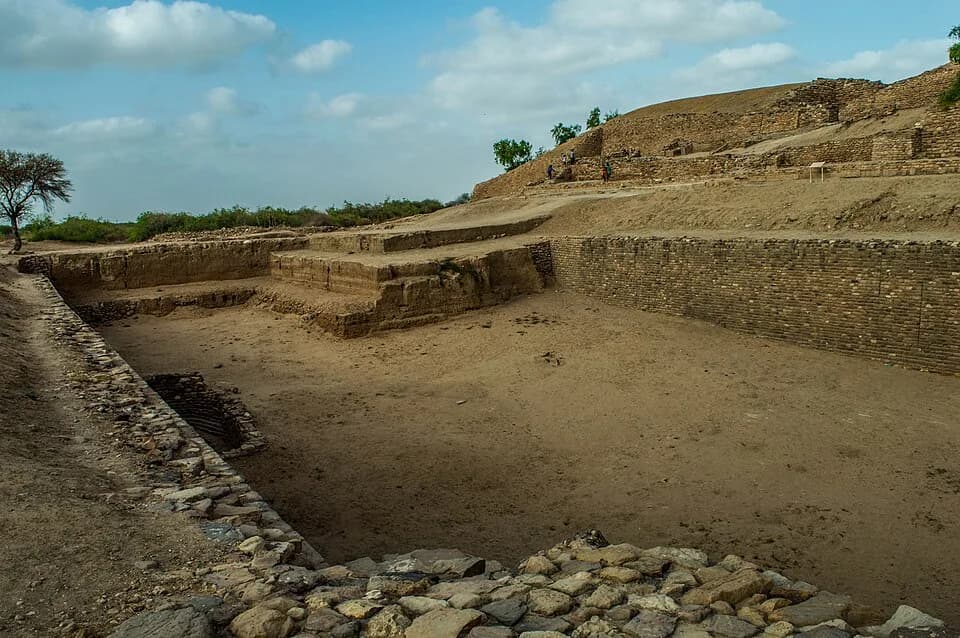
Dholavira stands on Khadir island in Gujarat with the salt flats of the Great Rann of Kutch on every side.
Archaeologists found ten large white signs here, lying in a chamber beside the north gate. Each sign is more than a foot tall. Nobody can read them.
The traditional view
UNESCO added Dholavira: a Harappan City to the World Heritage List in 2021. It says the city was occupied between about 3000 and 1500 BCE and calls it one of the best preserved urban settlements of its period.
The walled city has a fortified castle with a bailey and a ceremonial ground, a fortified middle town and a lower town. UNESCO adds that a series of reservoirs lies to the east and south of the citadel.
The site was excavated for 13 field seasons between 1989 and 2005. R.S. Bisht, who led the work, says the dig revealed "seven significant cultural stages documenting the rise and fall of the Indus civilization." His summary is reproduced in an annotated compilation by S. Kalyanaraman.
The city sits between two monsoon channels, the Manhar and the Mansar. Bisht writes that the builders made about sixteen or more reservoirs and arranged them in a series on all four sides. He puts the water works at about 10 hectares, or 10 percent of the area inside the outer fortification.
The largest reservoir he describes measures 73.40 meters by 29.30 meters at the top. Its floor was cut in three levels and the deepest, as far as the dig has reached, is 10.60 meters down.
UNESCO says most Harappan towns stood near rivers and perennial water. It says the island location of Dholavira "was strategic to harness different mineral and raw material sources" and to support trade with the Oman peninsula and Mesopotamia.
What Stays Open
In Earthly Enigmas I write that history books treat the ancient world as a series of isolated experiments. I place the Indus Valley planned cities inside that argument in Chapter 5. I also list Mohenjo-Daro among the 17 sites on Jim Alison's great circle.
The Plan, the Sign and the Water
Both views lean on questions the evidence cannot yet answer. Three of them stand out.
Was the plan drawn first, or grown into?
UNESCO calls Dholavira an outstanding example of Harappan urban planning with "preconceived city planning." Bisht writes that the city in its fullest form was "a precisely proportionate whole" laid out "with mathematical precision and, perhaps, with astronomically established orientation."
He gives the east-west length of the city as 771.10 meters and the north-south length as 616.87 meters, "thus giving the precise ratio of 5 : 4." A table in the same text and the Frontline report both give the length as 711.10 meters. Only the first figure gives 5 to 4. I have not seen the printed report.
Bisht also writes that the planning laid down in Stage I "formed the nucleus on which the subsequent settlements of the later stages expanded gradually." After a catastrophe in Stage III he says "the lower town was added and the city-walls were extended further eastwards in order to enclose the new additions." Frontline reports the catastrophe as an earthquake.
Michel Danino reads the proportions as a design principle. His abstract says the town planning "rests on the conscious use of specific proportions for its successive enclosures." He calculates a unit of 190.1 centimeters and says the Arthashastra's scheme of linear measures "conclusively has Harappan roots." In the Frontline report he said that further research was under way to validate the unit. I have read only his abstract.
J. Mark Kenoyer measured artifacts at Harappa. He found "some degree of standardization" in proportions such as the 1:2:4 brick ratio but "little evidence for rigorous standardization within the site itself." He was writing about Harappa. I have not found his comment on Dholavira's plan.
Was the city of 5 to 4 drawn before the first wall went up, or did it find that ratio as the stages were added?
Who was the signboard for?
Bisht says the ten signs are gypsum inlays. He writes that they "could have been fitted on a wooden signboard, most probably fitted above the lintel of the central passageway of the gate." In another passage he says the board was probably mounted "so as to be visible from afar for its white brilliance." The same text says the exact meaning "is not known in the absence of decipherment of the script."
Harappa.com describes each symbol as about 37 centimeters high on a board about 3 meters long. It says one symbol repeats four times and that the board was in use in Stage IV. It places the board "just outside the north entrance" while Bisht's text puts the find in the western chamber of the gate.
Atlas Obscura reports that Bisht believes an earthquake could have dislodged the board and that the people of Dholavira then moved it to a storeroom beside the gate. That is the reporter's account of his belief. I have not seen it in Bisht's own writing.
Steve Farmer, Richard Sproat and Michael Witzel call it a "famous three-meter wide 'signboard'." They say some inscriptions suggest the sign that repeats four times is a sun or power symbol. They argue the Harappans had no true script and read the signs as a nonlinguistic system. The Indus Seal article sets out that debate.
An independent researcher, Jagadish Metla, posted a paper on Academia that reads the board by its setting. His abstract proposes an "access-identification interpretation" and says current evidence does not "distinguish this proposal decisively from other institutional or ceremonial functions." I have read only the abstract.
S. Kalyanaraman reads it differently. In his compilation he says the board "was an announcement of the metalwork repertoire of dhokra kamar, cire perdue metalcasters and other smiths." I have not checked whether other specialists accept that reading.
What was a sign that large meant to tell a person walking up to the gate?
What ended the water system?
Bisht's summary says Stage V "is characterized by the general decline particularly in the maintenance of the city." He says the largest reservoir "got damaged beyond repairs by the authorities" in Stage V. He adds that the reservoirs of the southern series became defunct sometime in the same stage.
Frontline puts the end of Stage V at about 2000 BCE. It says the settlement was then abandoned for several decades and reoccupied on a smaller scale. UNESCO gives the whole occupation as about 3000 to 1500 BCE. Harappa.com says the site was occupied from about 2650 BCE and began to decline slowly after about 2100 BCE.
A 2020 paper in the Journal of Quaternary Science dated carbonates from seven cultural stages. Its authors include Bisht. Their abstract gives the occupation as about 5500 to 3800 years BP. It says a "catastrophic drought" drove "the final collapse of the settlement of Dholavira exactly at the onset of the Meghalayan (Late Holocene) stage." I have read only the abstract.
The geologist Mahesh Thakkar tells Atlas Obscura that the Indus Valley people lost basic needs such as fresh water as the climate changed slowly. Bisht writes of damage done by the authorities. Neither source says how those two accounts fit together.
What ended the water system?
The questions I can't put down
Some questions need more room than one article gives them. Two of them keep pulling me back.
Why build a city on a salt island? UNESCO says the location was strategic for its minerals and its trade. The 2020 abstract describes Early Harappan mangroves and seawater that periodically flooded the Great Rann. Bisht's summary describes a settlement between two monsoon channels. The book asks whether the ancient world was really a series of isolated experiments, and trade with Mesopotamia and Oman belongs in that picture. I follow that argument through Earthly Enigmas.
How did the same stonework turn up hundreds of kilometers away? Frontline reports Bisht saying that architectural members at Mohenjo-daro and Harappa were "made of the same stone and with similar shape, size and craftsmanship." He says they were finished at Dholavira. I have not checked that with the excavators of the other two cities. Chapter 5 of the book is about shared construction signatures between distant sites. You can read a free sample before you decide. The articles section has more subjects in the same format.
Sources
- UNESCO World Heritage Centre: Dholavira, a Harappan City
- R.S. Bisht, excavation summary from the Archaeological Survey of India, in S. Kalyanaraman's annotated compilation
- Frontline: The rise and fall of a Harappan city (T.S. Subramanian, 2010)
- Harappa.com: Dholavira and Its Mysterious Sign Board
- Atlas Obscura: The Mystery of the World's Oldest Billboard
- Farmer, Sproat and Witzel, The Collapse of the Indus-Script Thesis (2004)
- Danino, New Insights into Harappan Town-Planning, Proportions and Units (abstract only)
- Kenoyer, Measuring the Harappan World (2010), first ten of seventeen pages read
- Sengupta and others, Did the Harappan settlement of Dholavira collapse during the onset of Meghalayan stage drought? (2020, abstract only)
- Metla, The Dholavira North Gate Signboard as Access-Identification Signage (Academia, undated, abstract only)