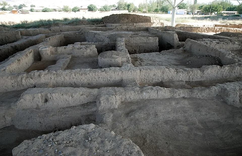
In 1976 a villager found a few objects on the surface of a freshly ploughed field. One of them was a bronze axe, according to ICOMOS. That find led archaeologists to Sarazm.
The same report says the archaeologists have studied less than 4% of the protected land. The sources still disagree about how large the town was.
The traditional view
UNESCO inscribed the Proto-urban Site of Sarazm in 2010. It says the site "bears witness to the development of settlements in Central Asia from the 4th millennium BCE to the late 3rd millennium BCE."
The site lies in the Zeravshan valley in northwestern Tajikistan, about 15 km west of the town of Penjikent. ICOMOS describes four periods of occupation between 3500 and 2000 BCE.
Robert Spengler and George Willcox publish a slightly different set of dates, which they credit to the archaeologist Razzokov. They also write that all the dates they mention are uncalibrated. They call Sarazm "an Eneolithic (Chalcolithic)/Early Bronze Age agricultural urban outpost."
The Tajik Management Plan describes the buildings. It lists a religious building of 128 square meters and a six-room "palatial complex" measuring 16 by 16.5 meters. It also lists a communal granary of twelve rooms.
The Plan describes a burial in excavation IV that held a woman, a man and an adolescent. It says several thousand beads of steatite, lapis lazuli, cornelian, turquoise and silver lay on and around the woman. It says 49 gold beads decorated her hair and that her bracelets were made of shell from the Indian Ocean.
UNESCO says the town "had connections with the steppes of Central Asia, and in addition with the Turkmenian, proto-Elamite, Mesopotamian, and Indus worlds."
The record also holds some cautions. UNESCO calls the integrity of the property "ill-defined because of uncertainty about the precise boundaries of the proto-urban site." In 2007 the World Heritage Committee deferred the first nomination. It asked Tajikistan to "reduce the level of excavation on the site" and to rely more on non-invasive survey.
The Edge of the Network
In Earthly Enigmas I write that history books treat the ancient world as a series of isolated experiments. I argue for a network that links cultures with no documented contact. I also list Mohenjo-Daro among the 17 sites on Jim Alison's great circle.
The sources do describe contact. UNESCO places Sarazm at the north-eastern extremity of an area that stretches from Mesopotamia to the Indus and the Iranian plateau. ICOMOS reports interchanges with the Indus Valley.
The Questions the Plan Leaves Open
The documents and the papers lean on questions they cannot yet answer. Three of them stand out.
How big was the town?
The Management Plan says the settlement "exceeded 50 hectares during its most developed period, when Sarazm had a settled population of about 3000." ICOMOS gives "some 50ha" and "about 3,000 inhabitants." Elsewhere ICOMOS puts the possible surface area between 45 and 50 hectares and calls the archaeological urban area "around 47ha."
Spengler and Willcox give a wider range. They write that the visible area is 35 hectares. They report that Isakov suggested up to 90 hectares and that Besenval and Isakov suggested as much as 100 to 150. They add that even 35 hectares would make Sarazm larger than any of its known contemporaries in southern Central Asia. Gonur Depe, at 22 hectares, is the largest center in Margiana.
ICOMOS reports thirteen excavation zones covering about 2.5 hectares. It says the zones represent "less than 4% of the protected land." It also says the town "does not have a clearly defined plan" and had "no protective enclosure."
Spengler and Willcox write that the deposit never exceeds 2 meters in depth. Besenval and Isakov read that shallow deposit as evidence for phases of abandonment and structural erosion. That raises the question of how much of the settlement stood at one time.
I found no basis stated for the figure of 3,000 people in the Plan or in ICOMOS.
How large was Sarazm at any one time, and what is the figure of 3,000 based on?
Where is the tin?
UNESCO says the town played a role "in the working of metals, particularly tin and copper." The Management Plan calls tin Sarazm's export. It writes that mining of Zeravshan tin probably began at least a millennium earlier than the proven second-millennium mines, "as evidenced by tin-bronze metallurgy at Sarazm and the contemporary use of tin in the leading cities of Mesopotamia, like Ur." ICOMOS says recent studies confirm Sarazm's "role in the control of tin."
Vincent Pigott writes in the Encyclopaedia Iranica that analyses of bronzes from Sarazm "revealed only unalloyed copper." He cites the 1987 study by Isakov and colleagues. The abstract of that study counts 8 metallurgical samples. Pigott calls the result "particularly significant in view of the proximity of known tin sources in the Zeravshan valley."
In a 2018 chapter Pigott writes that tin-bronze "was not present at the site in any period." He cites David Anthony for that and calls it "a curious fact." I have not read Anthony.
A 2023 survey of Central Asian bronze by Daniel Berger and colleagues says that unalloyed, arsenical and leaded copper "dominated in the Early Bronze Age (3rd millennium BCE)." The survey covers the whole region and not only Sarazm.
Pigott dates the oldest documented tin mine in Central Asia, Mushiston in Tajikistan, to about 2400 to 1300 BCE. He places the mining at Karnab in Uzbekistan after 2000 BCE. Sarazm's four periods run from 3500 to 2000 BCE.
Spengler and Willcox report slag and crucibles from excavation II, dated to the third period. They say the 1987 study concluded that Sarazm copper was processed in a similar fashion to the work of contemporary coppersmiths in Mesopotamia, the Iranian Plateau and the Indus Valley. The Plan lists more than 150 metal artifacts, among them bronze axes. I have not seen which analysis stands behind the label bronze.
Which analyses show tin, or tin-bronze, in objects made at Sarazm?
Who came first?
ICOMOS says the settlement "may have been established on an earlier village of farmers dating back to the Neolithic." The Plan says the town "could have been established on an earlier late Neolithic village, still to be found." The Plan adds that the oldest period is missing from some excavations and thinly represented in others.
The documents then offer different accounts of the founders. The Plan lists "the waves of migration from southern Turkmenistan" among the forces that shaped the culture. ICOMOS writes that Sarazm "clearly belongs to the proto-urban cultural ensemble of southern Turkmenistan."
Pigott reports that Anthony describes Sarazm as a "northern colony" of the Namazga I-II culture, whose homeland lay in the foothills of the Kopet Dagh mountains of southwestern Turkmenistan. UNESCO's text puts the emphasis elsewhere. It describes a complementarity between the pastoral nomads of the mountains and the agrarian peoples of Transoxiane.
Who lived at Sarazm first, and where did they come from?
The questions I can't put down
Some questions need more room than one article gives them. Two of them keep pulling me back.
What brought Sarazm to an end? The Plan says the reasons for the abandon of Sarazm by its inhabitants "have not yet been identified." It lists migration, epidemic disease and an attack on a settlement that "wasn't fortified," and says none of these could be verified. ICOMOS lists the same three ideas. The Plan says the site lay abandoned for a thousand years until the villager's find. In Chapter 10 I follow what was lost and what survived, and the Göbekli Tepe article looks at a site that was buried on purpose. I follow that question through Earthly Enigmas.
Who carried the shells and the rosette? ICOMOS reports a thin gold rosette with twelve petals that gives a connection with the civilization of Ur. The Plan says the Indian Ocean bracelets may have come as finished objects from Gujarat or Kutch. It also says that trades with distant regions in the Near East "were carried out through intermediaries." Nobody names the intermediaries. In Chapter 5 I make the case for a network that links ancient cultures. The Ancient Merv article covers Bronze Age Gonur, and the Bactrian Princess article follows one statuette type and the far-flung parallels the specialists cite. You can read a free sample of the book before you decide. The articles section has more subjects in the same format.
Sources
- UNESCO World Heritage Centre: Proto-urban Site of Sarazm (entry 1141, Statement of Outstanding Universal Value)
- UNESCO World Heritage Committee decision 31COM 8B.29 (2007, nomination deferred)
- UNESCO World Heritage Committee decision 34COM 8B.25 (2010, inscription)
- ICOMOS Advisory Body Evaluation, Sarazm (UNESCO document 151855)
- Sarazm Management Plan 2006 to 2010, Republic of Tajikistan (UNESCO document 105347) (State Party document)
- Spengler and Willcox, Archaeobotanical results from Sarazm, Tajikistan (Environmental Archaeology 18, 2013)
- Pigott, Bronze i. In pre-Islamic Iran (Encyclopaedia Iranica IV/5, 2000)
- Pigott, The BMAC, the Seima-Turbino Horizon and a Possible Eastward Transmission of Tin-Bronze Technology (in How Objects Tell Stories, Brepols, 2018)
- Berger et al., The rise of bronze in Central Asia (Frontiers in Earth Science 11, 2023)
- Isakov, Kohl, Lamberg-Karlovsky and Maddin, Metallurgical analysis from Sarazm, Tadjikistan SSR (Archaeometry 29, 1987) (abstract only; the full text is paywalled)