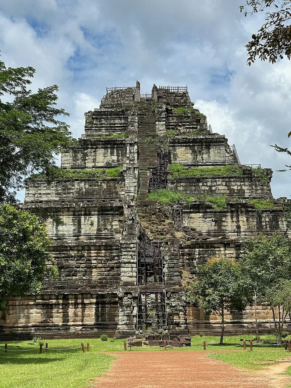
Prasat Prang rises out of the forest at Koh Ker. It is a stepped pyramid of sandstone, and the sources put its height between 35 and 38 meters.
For a short time in the tenth century the king of the Khmer Empire ruled from here. The site lies about 80 kilometers from Angkor.
The traditional view
UNESCO added Koh Ker: Archaeological Site of Ancient Lingapura or Chok Gargyar to the World Heritage List in 2023. The record calls it a capital of the Khmer Empire between 921 and 944 CE.
King Jayavarman IV founded the city in 921. For seven years it was one of two rival capitals, the other being Angkor. From 928 until 944 it was the sole capital. Then the political center moved back to Angkor.
The ICOMOS evaluation behind the listing says the name Lingapura means the city of lingas. It counts thirty temples and sanctuaries in the nominated area. It also lists a royal palace complex, three sandstone quarries and a reservoir called the Rahal that measures about 1,140 by 500 meters. Seventy-three inscriptions were found in nine temples.
UNESCO says the sacred city was believed to be laid out on ancient Indian concepts of the universe. It names two innovations. One is the Koh Ker style of sculpture. The other is construction with very large monolithic stone blocks.
The same text calls Koh Ker a short-lived capital and an interlude in Khmer history. It says the city was constructed in a single phase over twenty-three years. It also says the innovations had a lasting influence.
Damian Evans and colleagues mapped the area with lidar in 2012. They report that Koh Ker, like Phnom Kulen, was an open city with no clearly defined enclosure or city wall. They also report hydraulic engineering on a scale comparable to that of Angkor itself.
What the Evidence Does Not Settle
In Chapter 18 I write that LiDAR digitally strips away the canopy. I use Angkor as my example and I write that it was long viewed as an isolated temple complex.
Koh Ker lies under the same kind of forest. Evans and colleagues report that human changes to the ground cover essentially the whole 67 square kilometers of their Koh Ker survey block.
What Nobody Has Confirmed
The published work leaves several questions open. Three of them stand out.
How many phases does Koh Ker have?
UNESCO and ICOMOS both say the city was built in a single phase. ICOMOS adds that the layout may follow a preconceived sacred mandala.
Other researchers describe a longer sequence. Thierry Zéphir lectured on Koh Ker in 2015. The Society of Friends of the Cernuschi Museum summarized it. The summary says the central temple went up in 921 and the large pyramid behind it was added in 928. I have only seen that summary.
Etsuo Uchida, Kojiro Tsuda and Ichita Shimoda tested the laterite blocks and found five stages of construction. They believe the brick sanctuaries are the oldest, then the sandstone ones, and the laterite sanctuaries last. They report that buildings of the fifth stage remained unfinished.
Evans goes further in his survey of the landscape. He writes that it "cannot simply be claimed, on the basis of current evidence, that any great proportion of the remains have any kind of temporal coherence."
He says two decades of change would mean innovation "at a pace that was perhaps unparalleled" in the pre-Angkor and Angkor periods. He suggests the city may be "a vast palimpsest representing a succession of urban spaces."
Shimoda and Sato, who surveyed the temples on foot, read the common design as pointing to a construction period of no more than twenty years. They place one temple, Prasat Andong Kuk, later because of its layout and its reused stone blocks. ICOMOS records a small settlement in the sixth century and two temple complexes built after 944.
How many phases does Koh Ker have?
What fixed the angle of the plan?
Ichita Shimoda and Katsura Sato measured the main axis of Prasat Thom at 14 degrees off due east. They call that exceptional in Khmer temples, which traditionally face east. ICOMOS says the city is rotated fourteen degrees, presumably for symbolic, astronomical or political reasons.
Shimoda and Sato found that nine temples share axes between 13.5 and 16.4 degrees. Three large complexes south of the Rahal sit on a line 3,773 meters long, and the middle one lies about 3 meters from it. They note that nothing in the inscriptions, carving or style links those three temples.
ICOMOS reports that the nomination reads the layout as a sacred mandala. It adds that there are no known contemporary records or inscriptions to confirm the original planning methodology.
Shimoda and Sato offer one idea in a footnote. A geomagnetism study estimates about 14 degrees of west inclination in the tenth century. They write that "the use of a magnetic compass to align the site is worthy of consideration." I have not read that study.
Evans reads the evidence differently. He writes that "Much has been made of the unusual orientation of the monuments at Koh Ker."
In his view most monuments are "oriented quite conventionally." He explains the temples that face southwest by a second reservoir north of the Rahal. Each of them faces "an adjacent, formalised, rectangular body of water."
What fixed the angle of the plan?
How many people lived at Koh Ker, and where did they live?
ICOMOS says inscriptions indicate that more than 10,000 people lived in and around the city between 928 and 944. It describes the water system as the work that turned a flooded area into habitable land.
Shimoda and Sato report that their surveys found no solid traces of royal palaces or residential communities. Evans writes that the palace "has not been clearly identified." He says the settlement pattern and the population remain somewhat ambiguous and that a large population "remains to be proven at Koh Ker."
Evans also did a rough calculation for the land within a two hour walk of Prasat Thom. He writes that it "had the capability of supporting a population of more than 30,000 people without large-scale engineering works such as the Rahal." He calls his figures provisional.
He reads the inscriptions as saying that only the king and his royal court moved to Koh Ker and back. He finds it "almost impossible to imagine" that a city of some hundreds of thousands relocated wholesale to Koh Ker and back. That is his figure for Angkor, and he puts the return within one or two generations.
How many people lived at Koh Ker, and where did they live?
The questions I can't put down
Some questions need more room than one article gives them. Two of them keep pulling me back.
What stopped the roofs from going on? Shimoda and Sato describe three sandstone sanctuaries with finished walls and no roofs. Their pedestals are each carved from one stone and measure up to 4.3 meters square. Evans reports that Henri Parmentier suggested the difficulty of moving sandstone from distant quarries may explain the unfinished temples. Uchida and his colleagues place quarries 5 and 6 kilometers from Prasat Thom. Evans says the bulk of the building material likely came from the Koh Ker area. None of the sources I read says how the blocks were moved. In Chapter 3 of Earthly Enigmas I follow the same how-question through the stonework at Giza and Puma Punku. The Puma Punku article looks at one site in detail.
What is the oldest thing at Koh Ker? ICOMOS gives the earliest occupation as a small settlement in the sixth century. Evans reports thermoluminescence dates on ceramics from Prasat Kracap by Sipos, Belényesy and Bozsó. Most fall between the tenth and thirteenth centuries, and two samples are about 1700 and 4000 years old. He finds the 4000 year date "rather difficult to take at face value." I have not seen their paper. In Chapter 4 I follow dates that sit badly with the accepted sequence, and the Göbekli Tepe article is the closest example. You can read a free sample of the book before you decide. The articles section has more subjects in the same format, including Angkor Wat.
Sources
- UNESCO World Heritage Centre: Koh Ker: Archaeological Site of Ancient Lingapura or Chok Gargyar
- UNESCO Decision 45 COM 8B.8 (2023)
- ICOMOS evaluation of Koh Ker (2022)
- Damian Evans, The Archaeological Landscape of Koh Ker, Northwest Cambodia (BEFEO 97-98) (read from the open copy at the Angkor Database)
- Evans et al., Uncovering archaeological landscapes at Angkor using lidar (PNAS 110, 2013)
- Shimoda and Sato, Religious Concept in the Layout of the Ancient Khmer City of Koh Ker (Udaya 10)
- Uchida, Tsuda and Shimoda, Construction sequence of the Koh Ker monuments (Heritage Science 2:10)
- Society of Friends of the Cernuschi Museum: summary of Thierry Zéphir's 2015 lecture on Koh Ker (secondary, a summary rather than the lecture)