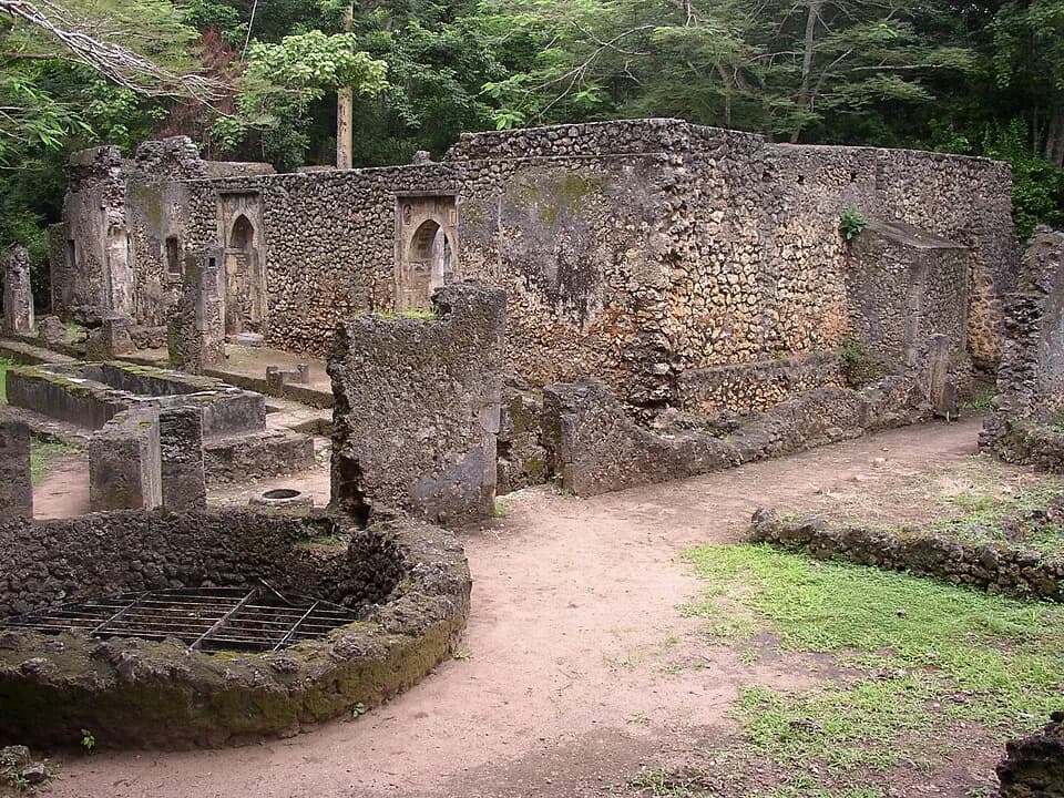
Walk into the forest at Gedi and the walls begin to appear between the trees. There are mosques, tombs, a palace and streets laid out on a grid.
Goods from China, Persia, India and Venice turned up in the ruins. The Indian Ocean lies about six kilometers away.
The traditional view
UNESCO calls Gedi "one of the most important and densely populated Swahili cities on the East African coast" in the period from the 10th to 17th centuries. It adds that the town was particularly important between the 15th and 17th centuries. It describes two rings of walls, a palace complex, a Grand Mosque, and mosques and tombs inset with Chinese porcelain.
The ICOMOS evaluation says the wealthy lived inside the inner wall. The outer wall enclosed farm and plantation land with mud and wattle houses for the middle class. It says peasants lived outside the walls.
UNESCO lists luxury goods from China, Persia, India and Venice found at Gedi. It says the trade was supported by exports of gold, ivory, minerals and timber "as well as slaves." It also credits the town with "a sophisticated water engineering and management system that is still readable."
ICOMOS says Swahili is a Bantu-speaking culture that absorbed influences from other parts of the Indian Ocean world and combined them with local culture. Wolfgang Alders reports that James Kirkman, who excavated Gede between 1948 and 1958, argued for a "sub-Arab" builder culture. Alders says post-colonial scholars have largely refuted that view.
The place is still in use. The National Museums of Kenya says the forest is a sacred site for traditional rituals and sacrifices for the surrounding community. ICOMOS says people from Arab and Swahili communities visit to pray at several mosques.
What the Ruins Leave Open
UNESCO describes Gedi as part of a complex network of trade and cultural exchanges that crossed the Indian Ocean. In Earthly Enigmas I write that history books treat the ancient world as a series of isolated experiments.
What Nobody Has Settled
The accepted account has gaps of its own. Three of them stand out.
Why is a trading town six kilometers from the sea?
UNESCO and ICOMOS both give the distance as 6.5 kilometers. A 2023 survey paper by Caesar Bita and Wes Forsythe says Gedi's "lack of seaward connectivity has perplexed scholars."
ICOMOS calls the distance "an intriguing element worthy of continuing research." It notes "a number of theories about the inland location." It says the trade suggests "additional networks with the African interior or systems of transhipment that are not well understood at this stage." It adds that the inland location "could also be related to defensive needs."
Bita and Forsythe found a cluster of house sites at Chafisi, on the part of Mida Creek closest to Gedi. They suggest it may have been an outport for the stone town. They also write that the pottery sample was modest and from an unsecured context.
They say the creek's environmental history is poorly studied. They report that Kirkman dismissed any relationship between Gedi and creek sites such as Kilepwa and Shaka.
Two other accounts point the other way. The Encarta Africana entry on the PBS site says Gedi "probably did not participate directly in the trade that linked towns along the Swahili Coast." Bita and Forsythe write that Gedi seems to have been less important than Malindi and Mambrui, which were mentioned in medieval texts. The entry also says no Portuguese or other written record from the time mentions Gedi. I have not checked that.
Stéphane Pradines titled his 2010 book Gedi, une cité portuaire swahilie, which means a Swahili port city. I have not read it.
How did goods reach a town six kilometers from the sea, and why was it built there?
Why did the last families leave?
The National Museums of Kenya says the abandonment "is believed to be as a result of a number of factors." It lists a raid by the Wazimba in 1589 and the move of the Sheikh of Malindi and the Portuguese to Mombasa in 1593. It also lists a falling water table, shown by the deepening of the well outside the Great Mosque. It adds the threat from a group it calls the Galla. It says the last families left in the first half of the seventeenth century.
The Encarta entry says archaeologists "can offer no definitive answers." It lists a Portuguese or Galla attack, a falling water table and some sort of epidemic. It says Gedi was abandoned in the 16th century and reoccupied for a short time before the final abandonment in the early 17th.
David West Reynolds wrote in Archaeology that the city "probably suffered from Portuguese incursions, and was finally destroyed by hostile Somali nomads sometime in the early seventeenth century." ICOMOS says the inland location "could possibly be a factor in why Gedi was not reoccupied later."
Each account names a different mix of causes. Was it one event or several, and which came first?
When did Gedi begin, and when was it at its height?
The dates depend on who you read. UNESCO gives the 10th to 17th centuries. ICOMOS says Gedi flourished between the 12th and 15th centuries. UNESCO calls it particularly important between the 15th and 17th.
The National Museums of Kenya says the town traces its origin to the twelfth century and was rebuilt with new walls in the fifteenth and sixteenth. Its 2024 press release says the culture thrived from the 13th to 17th centuries. The Encarta entry says Gedi was founded in the 13th century. Reynolds says the fourteenth.
Bita and Forsythe report that Kirkman dated the occupation to the 12th through 16th centuries with a peak in the 15th to early 16th. They report that Pradines claimed Gedi began as a village in the 11th century. They add that Swahili local wares have a broad date range, so chronologies lean on imported pottery.
Which dates belong to which wall, house and street?
The questions I can't put down
Some questions need more room than one article gives them. Two of them keep pulling me back.
How many people lived here? UNESCO calls Gedi densely populated. Reynolds writes that some 2,500 people may have lived there at its height. Alders reports an argument that Gede was comparable in size to the largest coastal towns. I have not checked that. In Chapter 3 of the book I give population figures for Cahokia and Teotihuacan. I follow that question through Earthly Enigmas.
How did goods from so far away end up in a forest? Alders reproduces Kirkman's map, which names a House of the Venetian Bead, a House of the Chinese Cash and a House of the Ivory Box. In Chapter 5 I write that history books treat the ancient world as a series of isolated experiments. You can read a free sample before you decide. The Great Zimbabwe article looks at another African stone town that ICOMOS used as a comparison. The articles section has more subjects in the same format.
Sources
- UNESCO World Heritage Centre: The Historic Town and Archaeological Site of Gedi
- ICOMOS Evaluation, Gedi (Kenya), No 1720, March 2024
- National Museums of Kenya: Gede Museum
- National Museums of Kenya: The Historic Town and Archaeological Site of Gedi (inscription release, 2024)
- Bita and Forsythe, An Outport for Gedi? Archaeological Survey in Mida Creek, Kenya, Heritage 6(12), 2023
- Alders, Archaeological Survey and Landscape History at Gede, Kenya, Nyame Akuma
- Reynolds, Swahili Ghost Town, Archaeology 54(6)
- PBS Wonders of the African World: Historic Gedi (text from Microsoft Encarta Africana, 1999) (secondary encyclopedia entry)
- Wikipedia: Ruins of Gedi (used only to locate sources; no fact is taken from it)