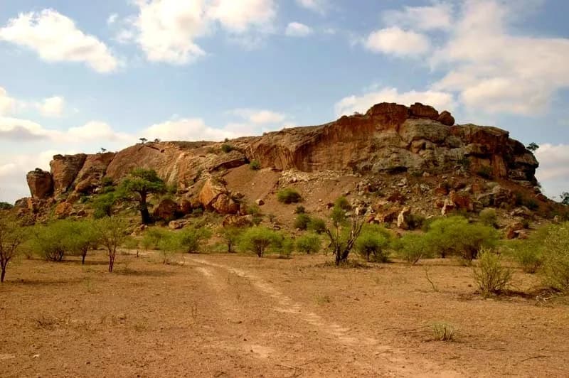
Mapungubwe Hill is a flat-topped sandstone hill in the Limpopo valley. SANParks describes a narrow path hidden in a cleft in the rock as the way to the top.
Excavators opened graves on the summit during the 1930s. UNESCO now calls the landscape around the hill the rise and fall of the first indigenous kingdom in Southern Africa. Both the claim to be first and the date of the fall carry published arguments.
The traditional view
UNESCO describes the Mapungubwe Cultural Landscape as the rise and fall of the first indigenous kingdom in Southern Africa between 900 and 1,300 AD. It names three capitals. They are Schroda, Leopard's Kopje and a final one around Mapungubwe hill.
UNESCO says the kingdom controlled trade through East African ports to India and China. It harvested gold and ivory from its hinterland. The evidence shows a sacred leadership in which "the king was secluded from the commoners."
The Metropolitan Museum's timeline essay calls Mapungubwe the earliest known site in southern Africa where leaders were "spatially separated from their followers." The commoners lived at the foot of the hill and on the plateau around it.
Thomas Huffman and Stephan Woodborne trace a pottery sequence from Zhizo through Leokwe, K2 and Transitional K2 to Mapungubwe. They write that trade wealth and intensive agriculture helped turn a society with hereditary leadership at K2 into "a class-based society with sacred leadership at Mapungubwe."
Their dates put the change from K2 pottery to Transitional K2 pottery at about AD 1150. Mapungubwe pottery came about 120 years later and lasted about 50 years.
UNESCO blames the end on climate change and says power moved north to Great Zimbabwe. Huffman and Woodborne write that a drought dated to about AD 1310 contributed to the abandonment.
UNESCO also says the standard of the 1930s excavations "could be argued" to have lost valuable evidence. Counts of the hilltop graves differ. SANParks and the Met give 23. John Giblin writes of 27 burial sites.
SANParks says the remains of about 147 people were excavated from the landscape between 1933 and 1998. Representatives of descendant communities asked government to arrange their return. The remains were reburied on 20 November 2007.
What the Hill Does Not Say
In Earthly Enigmas I write that history books treat the ancient world as a series of isolated experiments. I make that case in Chapter 5. In Chapter 7 I write about gold. I describe circular stone structures, roads and terracing across about 1,500 square kilometers in Mpumalanga, a gold-rich region of South Africa, with no official age assignment.
The published work on the hill leaves its own questions open. The gold rhinoceros has a separate article, The Mapungubwe Gold Rhinoceros, which follows that object and its dates. This article asks about the settlement. Three questions stand out.
Where the Accounts Don't Meet
Was Mapungubwe the first?
Huffman and Woodborne call Mapungubwe "the capital of the first indigenous state in southern Africa." Shadreck Chirikure and colleagues disagree in a 2014 paper on Mapela Hill in southwestern Zimbabwe. Their Bayesian chronology dates stone-walled terraces there to the 11th century CE, "almost two hundred years earlier than Mapungubwe."
They write that Mapela "flourished between CE1055 and CE1400." They conclude that Mapungubwe "can no longer be regarded as the sole cradle of the Zimbabwe culture." They say this calls for significant adjustments to existing models.
The same authors note that Huffman had already pointed out that the status of Leopard's Kopje walls in southwestern Zimbabwe "has not been fully considered." They also say they present evidence from one site. I have not checked whether Huffman has replied in print.
What would settle which place came first?
How many people lived there?
Three published figures sit side by side. The Met says Mapungubwe "may have reached a population of 5,000." SANParks says the cultural landscape sustained "at least 9,000 people" between AD 1220 and 1300. Huffman and Woodborne write that "over 10 000 people lived in the valley" during the Mapungubwe phase.
The figures may describe different areas. The Met speaks of the city, SANParks of the landscape and Huffman and Woodborne of the valley. Huffman and Woodborne assign 50 people to each homestead for 50 years. They call the result a count of populations "in relative terms rather than as an absolute census."
For the reach of the kingdom, Huffman wrote in 2000 that Mapungubwe "probably controlled about 30 000 sq km." He reasoned from a link between settlement hierarchies, settlement size, population and territory, and he compared it to polities such as the Zulu. I read that line in an excerpt of the chapter hosted on Academia.
UNESCO gives a core area of nearly 30,000 hectares. That figure measures the protected property, while Huffman's measures an estimated territory.
How many people lived under the hill's rulers, and how far did their authority reach?
When did the hill's people leave?
UNESCO gives more than one date on a single page. The short description says the kingdom was abandoned in the 14th century. The longer text speaks of a demise at the end of the 13th century. It also says the land could no longer sustain a high population when rainfall decreased after 1300 AD.
The Met essay says Mapungubwe flourished from 1220 to 1290 or 1300 in one section. In another it says the capital was "thriving only from 1290 to 1300."
Huffman and Woodborne put the abandonment at about AD 1320. They date a drought at about AD 1310 from a baobab record.
Linda Prinsloo and colleagues report that many pigments in glass beads from the hill were made after the 13th century, some in the 19th century. They say this raises questions about the revision of the hill's last occupation date to 1290 AD. Their introduction says that date rested on seven radiocarbon dates. It also summarizes an earlier excavator's estimate of the middle of the 19th century. I have read the abstract and the introduction only.
In 2024 Chirikure and colleagues, writing from Mapela and Little Mapela, question the drought explanation. They write that neighboring societies "persisted and thrived through the same climatic challenges."
When did people leave the hill, and why did they go?
The questions I can't put down
Some questions need more room than one article gives them. Two of them keep pulling me back.
Who was credited with building places like this one? Jane Carruthers writes in a 2006 paper that Europeans long credited Phoenicians, Romans and other outsiders with the walled sites between the Limpopo and the Zambezi. She adds that Mapungubwe faded from history twice, the second time after 1949 "when it was suppressed." That is one scholar's view and I have not checked it against the original records. In Chapter 17 of Earthly Enigmas I describe a four-stage pattern in how institutions respond to a discovery. The section is called "The Archaeological Suppression Pattern." I put her account beside that pattern and leave the comparison to you.
Where did the beads come from? UNESCO says the kingdom's wealth showed in Chinese porcelain and Persian glass beads. Prinsloo and colleagues list India, Fustat in Egypt and Venice as places proposed for the older beads. They say three celadon shards from the hill were re-dated from the Song dynasty to the Yuan or early Ming. In Chapter 5 of the book I write about contact between distant cultures, and a Limpopo hilltop with Indian Ocean beads sits inside that question. You can read a free sample before you decide. The articles section has more subjects in the same format.
Sources
- UNESCO World Heritage Centre: Mapungubwe Cultural Landscape
- SANParks: Natural and Cultural History, Mapungubwe National Park
- Metropolitan Museum of Art, Heilbrunn Timeline: Mapungubwe (ca. 1050-1270)
- Huffman and Woodborne, New AMS dates for the Middle Iron Age in the Mapungubwe landscape (South African Journal of Science 117, 2021)
- Huffman, Mapungubwe and the origins of the Zimbabwe culture (Goodwin Series 8, 2000) (excerpt hosted on Academia)
- Chirikure et al., Zimbabwe Culture before Mapungubwe: New Evidence from Mapela Hill, South-Western Zimbabwe (PLOS ONE 9, 2014)
- Chirikure et al., Archaeology, climate change and human adaptation in southern Africa: Evidence from Mapela and Little Mapela (Quaternary Science Advances 15, 2024) (abstract only)
- Prinsloo, Tournié and Colomban, A Raman spectroscopic study of glass trade beads from Mapungubwe hill and K2 (Journal of Archaeological Science 38, 2011) (abstract and introduction only)
- Carruthers, Mapungubwe: an historical and contemporary analysis of a World Heritage cultural landscape (Koedoe 49, 2006)
- John Giblin, The Conversation (2016)