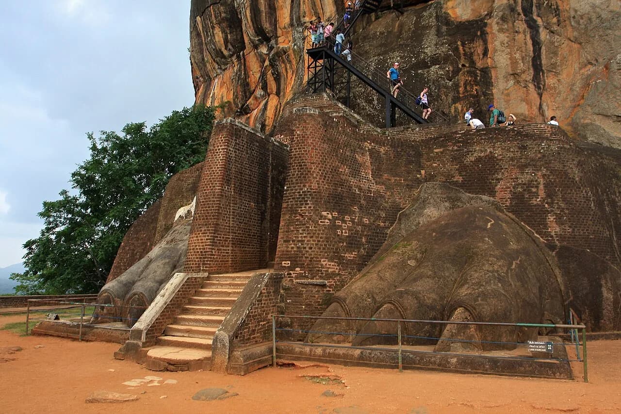
Two huge brick paws sit on a terrace on the north side of a granite rock in central Sri Lanka. Wilhelm Geiger, who translated the chronicle that tells the rock's story, wrote that the claws "reach to the breast of a man standing upright."
What remains of the lion is those paws. The question the rock keeps asking is how much of its story we can read from what is left.
The traditional view
UNESCO describes the ruins as "the capital built by the parricidal King Kassapa I." It places them on the slopes and summit of a granite peak about 180 meters high. It adds that "galleries and staircases emerging from the mouth of a gigantic lion constructed of bricks and plaster provide access to the site." The entry gives his reign as 477 to 495. Impart reports that the site was designated a World Heritage Site in 1982.
The main written source is the Culavamsa, a Pali chronicle. In Geiger's translation it says Kassapa "betook himself through fear" to Sihagiri after he failed to kill his brother. It continues that he "cleared (the land) round about, surrounded it with a wall and built a staircase in the form of a lion." It says the name came from that staircase. It adds that he "built there a fine palace, worthy to behold, like another Alakamanda and dwelt there like (the god) Kuvera."
Impart says Kassapa took the throne by killing his father and driving his brother, the rightful heir, into exile in southern India. It reports that the site re-emerged as a monastery after Kassapa's death.
The site also holds a painted gallery and a polished brick wall, the Mirror Wall. Impart says 22 painted women survive on the rock face. Visitors scratched verses on the Mirror Wall for centuries. Impart counts about 1,800 graffiti. Divya Kumar-Dumas counts more than 1,400 verses from the 7th to the 13th century.
Below the rock lie the water gardens. Kumar-Dumas describes a four-part garden about 115 meters on a side and a fountain garden where "gravitational pressure forced water (conducted via underground pipes) up through the holes."
H.C.P. Bell led the excavations. According to a 1905 guidebook by Burrows, work began in 1895 and Bell unearthed the claws in 1898. Archaeologist Disha Ahluwalia adds in a ThePrint opinion piece that some social media accounts link the rock to Ravana of the Ramayana. She writes that it is the fortress of Kassapa I.
What the Evidence Does Not Settle
The sources I read agree on what the rock holds. They split on who lived there, what the lion looked like and who the painted women are.
The Questions the Rock Keeps
Three questions stand out. Each rests on sources that disagree.
Did a king live on the summit?
UNESCO and the Culavamsa both credit Kassapa with building here. Kumar-Dumas notes that a monk named Dhammakitti redacted that chronicle passage in the 13th century. She also reports that a visitor of the late 8th or early 9th century "prefaces his poem with his expectation of a palace."
Bell found brick rooms, terraces, a cistern and a pond on the summit. Burrows quotes him on "the complete absence of monolith pillars and stone-carved doorways." Bell wrote that above the floor "all was of brick or wood."
Raja de Silva, a former Archaeological Commissioner, reads the same rock differently. He writes that "there being no evidence of a palace on the summit, there is no reason to believe that Kassapa lived there." He holds that Sigiriya was "a long-standing Buddhist monastery." Impart supports an earlier religious use. It reports a monastic complex around the rock from the third century BCE, with Brahmi inscriptions naming patrons.
What would show it either way? Kumar-Dumas writes of the water architecture, "Neither inscriptions nor scientific dates support the case." I have not checked whether anyone has dated the summit rooms directly.
How much of the lion can we say?
The chronicle says Kassapa "built a staircase in the form of a lion." Geiger's footnote says the structure was brick and had the form of a recumbent lion, "perhaps of the fore part of the body." He then writes, "I am inclined to think that this staircase was of wood."
Burrows says that until Bell found the claws "there was nothing to show how the rock came by its name." UNESCO describes access through "the mouth of a gigantic lion." National Geographic History describes passageways "between a monumental pair of lion paws." Geiger's note mentions the "outstretched right paw."
The meaning of the lion is also open. De Silva says it stood at a gateway to remind the devotee "of the Buddha, the Sakya-simha." In his account Paranavitana saw a copy of the lion on the Plateau of Red Arsenic in Kalidasa's poem Meghaduta. De Silva does not accept that comparison. I have not read Paranavitana directly.
How much of the lion do two paws and one line of a chronicle allow us to say?
Who are the women on the wall?
Bell thought the paintings showed "a procession of the queens and princesses of Kasyapa's court" on their way to worship at a nearby Buddhist site. Impart adds that Ananda Coomaraswamy proposed apsaras. Senarath Paranavithana proposed personifications of the clouds and lightning of Alakamanda. Senake Bandaranayake suggested the costume and jewelry reflect courtly life. Impart sums it up this way: "None of these theories are conclusive."
De Silva proposes the goddess Tara. He dates the paintings to "sometime after the beginning of the 6th century AC, probably towards the middle." He argues that the Mirror Wall verses were written long after the paintings and are "of not much relevance for the elucidation of the subject." Impart reads those verses as a record of how medieval visitors responded to the women.
Every reading depends on who the rock belonged to. If we do not know who lived here, how do we know who the women are?
The questions I can't put down
Some questions need more room than one article gives them. Two of them keep pulling me back.
Who laid out the water gardens, and when? Kumar-Dumas writes that crediting Kassapa with them "requires a suspension of disbelief." She adds that only one third of the site "has been carefully surveyed." A news report from the Mawrata site dated August 30, 2026 describes new LiDAR and radar surveys. It says the northern water garden is a mirror image of the southern one. It adds that the northern part was left unexcavated. I have not checked the survey report itself. In Earthly Enigmas I ask the same kind of question about dates at other sites. You can see how in the Göbekli Tepe article. The Rani ki Vav article looks at another water structure. I follow that kind of question through Earthly Enigmas.
Does the garden axis point at the sun? Amelia Sparavigna, a researcher at the Politecnico di Torino, writes that the axis of the complex is oriented "with the sunset of the zenithal sun." She measures the axis at about 9 degrees off east and west. She finds the sunset azimuth on April 9 and September 1, when the sun stands overhead, at about 8 degrees north of west. She works from satellite maps. I have not found a reply to her paper. In Chapter 5, "The Same Sky, Everywhere," I look at alignments to the sky at sites far apart. You can read a free sample of the book before you decide. The articles section has more subjects in the same format.
Sources
- UNESCO World Heritage Centre, Ancient City of Sigiriya (202)
- Geiger (trans.), Culavamsa, Part 1, chapter 39 (archive.org)
- Burrows, The Buried Cities of Ceylon, Sigiri chapter, quoting H.C.P. Bell (archive.org)
- Divya Kumar-Dumas, Sigiriya: An Early Designed Landscape in Sri Lanka (Orientations)
- Raja de Silva, The Sigiriya Ladies: Who were they, why were they painted? (sigiriya.org repost)
- Raja de Silva, review of Paranavitana's Sigiri study (lankalibrary.com repost, The Island)
- Impart, Sigiriya Murals and Mirror Wall
- Impart, Desires, Reactions, Interpretations: Murals and Inscriptions from Sigiriya
- Sparavigna, The Solar Orientation of the Lion Rock Complex in Sri Lanka (arXiv:1311.2853; International Journal of Sciences, 2013)
- National Geographic History, Sigiriya, the Lion Fortress of Sri Lanka
- ThePrint, Sri Lanka's Sigiriya wasn't Ravan's palace (Disha Ahluwalia)
- Mawrata News, LiDAR, GPR and gradiometry survey report, August 30, 2026 (read through a fetch tool's extraction)