Borobudur has 160 carved panels on its lowest level. A wall of added stone covers almost all of them. A short stretch at the southeast corner has been opened for visitors.
Nobody has settled why the builders hid them.
The traditional view
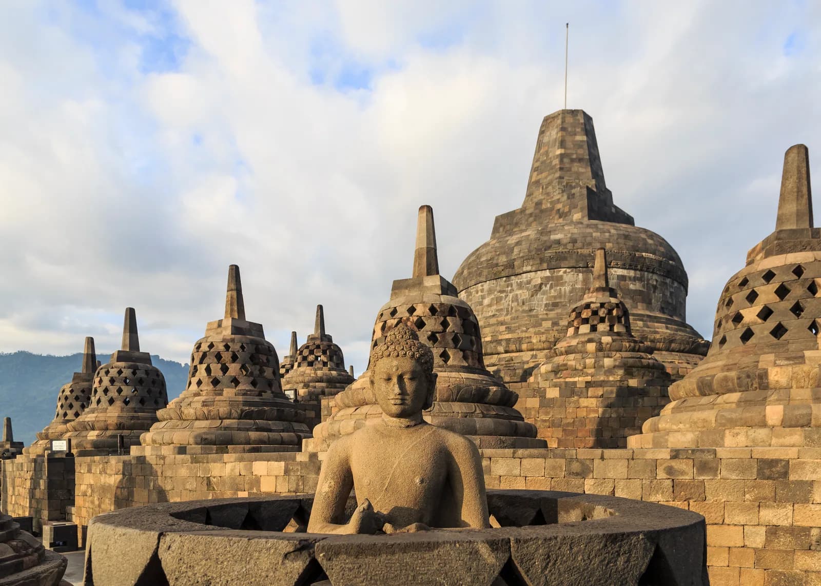
UNESCO describes the Borobudur Temple Compounds as a Buddhist monument built in the 8th and 9th centuries during the Syailendra Dynasty. It stands in the Kedu Valley in central Java. The main temple is a stupa in three tiers around a hill. A pyramidal base with five square terraces carries three circular platforms and a monumental stupa. Around the circular platforms stand 72 openwork stupas. Each holds a statue of the Buddha.
UNESCO reads the three divisions as Buddhist cosmology. It says the base represents kamadhatu, the sphere of desires. The five square terraces represent rupadhatu, the sphere of forms. The circular platforms and the big stupa represent arupadhatu, the sphere of formlessness.
The archaeologist Hariani Santiko counts 1,460 narrative panels, 1,212 decorative reliefs and 504 Buddha statues. She writes that King Samaratungga of the Sailendra dynasty built the temple in the 9th century. Murwanto and colleagues date construction to about 760 to 830 CE, citing John Miksic. Smarthistory says around 800 and adds that exact dates vary among scholars.
Santiko writes that the monument lay in ruins under trees and underbrush when H.C. Cornelius examined it in 1814 for Sir Thomas Raffles. UNESCO says the present state is the result of restorations in the 20th century. It also says enough original material survived to make a reconstruction possible. UNESCO adds that the site could serve again as a Buddhist pilgrimage site.
What the Record Leaves Open
Murwanto and colleagues write that "uncertainty continues to surround the palaeoenvironmental context" of the monument. Smarthistory says the dates vary. According to the Wikipedia article on the Karangtengah inscription, a stone dated 824 CE names a sacred Buddhist building that has been identified as Borobudur. I have not checked that in the original sources.
Uday Dokras has posted papers on Academia with titles that point to Hindu beginnings for Borobudur. I have seen only an abstract. It says "No records pertaining to its construction or purpose exist" and that the dating rests on comparisons of reliefs and inscriptions.
What Nobody Has Settled
Three questions stand out.
Why was the foot buried?
Santiko writes that the carvings on the hidden base are scenes from the Karmawibhangga text on cause and effect. She places them on the lowest level, the kamadhatu. J.W. Ijzerman and his group uncovered the panels in 1885. Kassian Cephas photographed them in 1890 and 1891 before the stones went back. She says the negatives are kept at the Tropenmuseum in Amsterdam.
Smarthistory gives a structural reason. It says buttresses "were added shortly after the building's construction in order to further support the structure's weight."
Gopal Kamal and Ritu Kamal wrote a paper on the hidden base for a 2008 seminar. They say the covering "could be for structural reasons" and note that Borobudur is "a hollow structure on a hill slope." They also quote Robert Fisher. He says the added stone may have been needed for the weight or may have been "a part of a plan to symbolise the suppression of the world of desire." He adds that the carvings at the Terrace of the Elephants in Angkor Thom were also enclosed "where structural reinforcement was not an issue."
The Kamals quote J.G. de Casparis on Jan Fontein. De Casparis writes that "neither of the two motives discussed there is wholly satisfactory." He says the doubt applies even more strongly to the technical view, a procedure "which is inefficient, as has been convincingly shown by Dumarçay." I have not read Fontein or Dumarçay myself.
A JSTOR article on the hidden foot offers a third idea. I saw only a search excerpt. It says some scholars hold that the reliefs "had been deliberately covered because they were at some point deemed morally inappropriate."
The Kamals conclude that "hiding the base was either the goal of the exercise, or a welcome side-effect." They point to a study that used laterite samples to establish the dates of different parts of the Angkor complex. They write that similar studies at Borobudur could show whether the hidden base was part of the original structure.
Why was the foot buried?
Did a lake lie beside it?
Santiko says the temple stands on a hill near the junction of the Progo and Elo rivers. She writes that the position follows a manual for artisans known as the Vastusastra. UNESCO says Borobudur is "laid out in the form of a lotus."
In 1931 and 1932 the Dutch scholar W.O.J. Nieuwenkamp pictured Buddha on a lotus floating on a lake that had since dried up. Murwanto and colleagues say he and Theodoor van Erp argued about it in print until 1937.
Murwanto and colleagues report that "Borobudur intentionally stood by an existing lake." They used resistivity and electromagnetic surveys, two cores 50 meters deep, pollen counts and radiocarbon dates. Fossil tree stumps on top of the claystone date to the 12th to 14th centuries. The authors write that "no suitable material for dating has been found in the Sileng River deposits to show exactly the time of temple construction." They reason that clay kept settling for about 20,000 years, so the lake may not have dried up for long.
A report in Tempo describes a team from the Geological Agency and the research agency BRIN that revisited the Sileng riverbank. Tempo says the layer once read as lake clay "contained 70% sand with high iron content." The team found no ostracods or diatoms, which are tiny lake organisms. A sample from rice fields 500 meters south of the temple was volcanic ash mixed with clay. The geologist Eko Yulianto told Tempo that "Scientifically, the existence of the lake has not been verified." He called the issue sensational, much like Gunung Padang.
A 2023 gravity survey by Permana and colleagues reports a deposit "thought to be an ancient lake" between 50 and 525 meters down. I read only the abstract. It does not say when that deposit formed.
Did a lake lie beside Borobudur when it was built?
What ended the pilgrimage?
UNESCO says the temple was used "until sometime between the 10th and 15th centuries when it was abandoned." Smarthistory says use ended roughly 100 years after completion for "still unknown reasons." Santiko writes that it was abandoned "with an unknown reason."
Murwanto and colleagues review the explanations. R.W. van Bemmelen proposed in 1949 that a volcanic disaster in 1006 drove the rulers east. The authors say most scholars have since doubted this. They give the majority view as a move to East Java in the middle of the tenth century, possibly 928. They say reports of ash on the temple at rediscovery "are inconsistent." Their cores show "no evidence of massive airborne fallout from Mt Merapi."
The authors add that about 43 smaller temples nearby "remained occupied until at least the thirteenth century." They suggest that the move may have been caused by "some water-related disease," since malaria persists on the plain. UNESCO still lists acidic ash from Mount Merapi as a threat.
The Wikipedia article on Borobudur says Soekmono assumed that abandonment followed the conversion of the population to Islam in the 15th century. I have not checked that in Soekmono's own text.
What ended the pilgrimage to Borobudur?
The questions I can't put down
Some questions need more room than one article gives them. Two of them keep pulling me back.
Did anyone draw a plan? Hokky Situngkir writes that "the architecture is not based on final master plan." He reports a fractal dimension of 2.325 and cites a survey by P. Atmadi that finds a head to body to foot ratio of 9 to 6 to 4. I have not checked either figure. The Kamals write that the plans "could have changed with time" over almost 60 years. It follows recurring geometry through other sites, and I list Buddhist art among the traditions where the Flower of Life recurs. I follow that question through Earthly Enigmas. The Sri Yantra article looks at one sacred diagram in detail.
Why do three temples share one line? UNESCO says Mendut and Pawon lie "on a straight axis to Borobudur" and that the three "represent phases in the attainment of Nirvana." Smarthistory says that at certain times of year the path of the rising sun seems to emerge from Mount Merapi and strike the temple's peak. I have not checked that. In Chapter 5 I follow the same sky through other sites, including the western causeway at Angkor Wat. The Angkor Wat article covers that case. You can read a free sample of the book before you decide. The articles section has more subjects in the same format.
Sources
- UNESCO World Heritage Centre: Borobudur Temple Compounds
- Hariani Santiko, Identification of Karmawibhangga Reliefs at Candi Borobudur (Amerta, 2016)
- Gopal Kamal and Ritu Kamal, Symbolic, Architectural or Metaphysical: The Hidden Base of Borobudur (2008 seminar)
- Murwanto et al., Borobudur temple stood by a lake (The Holocene 14, 2004)
- Tempo: Controversy Over Ancient Lake Theory at Borobudur Temple
- Permana et al., Identification of the Ancient Lakes Based on Gravity Methods in Borobudur Temple (JGE, 2023) (abstract and introduction only)
- Hokky Situngkir, Borobudur was Built Algorithmically (arXiv 1508.03649) (preprint)
- Smarthistory: Borobudur
- Uday Dokras on Academia: The PRALAYA and the disasters at Borobudur (abstract page only; the quoted line is from the abstract of a related paper on his profile)
- Wikipedia: Karangtengah inscription and Wikipedia: Borobudur (secondary, for the 824 inscription and the Soekmono assumption)
- JSTOR article on the hidden foot and artistic practice (search excerpt only)