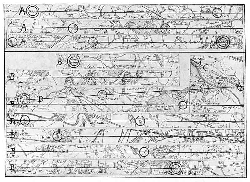
On the last day of June 1921 a Herefordshire businessman laid a ruler across a map. Churches, standing stones, burial mounds and old crosses seemed to fall into straight lines.
His name was Alfred Watkins. I keep asking whether he found a pattern in the land or drew one on the paper.
The traditional view
Watkins was a businessman, a pioneering photographer and a local councillor, according to The Guardian. His 1925 book The Old Straight Track argued that the lines were the remains of prehistoric tracks and trade routes. He pictured mounds, standing stones, notches cut in ridges, ponds and beacon fires as the marks that guided travelers.
The same article says he attributed neither mystical nor electrical properties to the alignments.
Watkins also asked the hard question himself. His preface says what matters is whether the lines are a humanly designed fact, an accidental coincidence or a mare's nest.
In the last part of the book he ran a test. The Andover map held 51 churches. Eight separate groups of four churches lay on a straight line, and one group of five did. He then marked 51 crosses at random on a similar sheet and found one line of four and none of five.
Three or more points lined up 34 times on the random sheet and 38 times on the real map. Watkins concluded that three-point alignment is valueless as proof. He called four-point alignment exceedingly strong evidence of design.
The academic answer came in 1983 with Ley Lines in Question by Tom Williamson and Liz Bellamy. Williamson described their test to The Guardian. On a map of the land around Avebury they joined every ley marker to every other and counted 130 alignments of six points. They then randomized each site's position inside its grid square and counted 127.
He says the randomized map scored slightly better than the real one. He adds that many mark points are areas and not dots, and that ancient sites are not scattered at random. Barrows cluster on chalk ridges and villages string along river valleys.
Williamson says the result does not prove there are no ley lines. It does undercut the claim that old sites on a map line up more often than chance would predict.
The Guardian reports that Watkins later accepted his trade-route idea made little sense in some cases. The mystical and energy ideas arrived after him, in the 1960s.
The Lines Between
In Earthly Enigmas I start with Watkins and his map. The standard answer is that the alignments were coincidental and that any random line will pass through several sites. I think that statistical argument has a problem. It assumes a uniform distribution of sites.
I do not say every ley line is real. Some are almost certainly coincidental. I write that rigorous probability analysis shows the strongest alignments exceed chance.
Then I turn to the whole planet. The more striking discovery, I write, came when researchers stopped looking at Britain and started looking at the whole planet.
Jim Alison found a single great circle that runs through 17 ancient sites. They include Giza, Siwa, Persepolis, Mohenjo-Daro, Sukhothai, Angkor Wat, Nazca and Easter Island. In 2025 Rosola Labs fitted the circle and reported an R-squared of 0.9998. I describe that fit as rigorous, measurable and replicable. I also mention a second and a third great circle.
I limit what the circle proves. I say plainly that none of this proves the ancients built on an electromagnetic grid. I call the results correlations and I invite readers to check the numbers.
I read the sites as markers, and I ask who knew enough about the whole planet to place them. I call the stone sites of my earlier chapters, Baalbek and Ollantaytambo among them, the opening case for something larger.
The Lines Nobody Has Settled
Both views lean on questions the evidence cannot yet answer. Three of them stand out.
Is it coincidence?
Two tests on British maps gave opposite answers. Watkins found far more four-point lines on a real map than on a random one. Williamson and Bellamy found about the same number of six-point lines on a real map and a randomized one.
Williamson reports a second check. They plotted ring ditches from aerial photographs on a map of south Cambridgeshire, where Watkins had worked. Ring ditches are crop marks left by plowed-out barrows. Williamson says none of them fell on the lines Watkins and others had drawn.
A paper by Dennis Doxtater of the University of Arizona takes up the critics' method. He argues that finding many random alignments in a large set does not rule out designed ones inside a smaller subset. For the 33 largest mounds in Scandinavia, the abstract says the real pattern matched or beat 98 of 100 random sets at the upper two accuracies. He reasons that some alignments were intentionally designed and that the set also holds random ones. I have read only the first part of that paper and I have not checked where it was published.
In the book I say the critics' statistic assumes a uniform distribution of sites. Williamson says his second objection was that sites are not randomly distributed, and that his randomized run kept the broad distribution of points across the map.
Do the real alignments rise above chance once the size and the real distribution of the sites are handled fairly?
What were the lines for?
Watkins thought each line was a sighted track. The Guardian reports that he later accepted the trade-route idea made little sense in some cases.
It also quotes Danny Sullivan, a former editor of The Ley Hunter journal. Sullivan says there is no single phenomenon that is a ley. He lists old tracks, alignments between sites and astronomical alignments. The article adds that Paul Devereux and Nigel Pennick later explored funeral paths and spirit paths as another reading of the lines. I have not read their book.
In the book I call the structures markers.
What job did a straight line across the land do?
Who chose the sites?
Alison's page lists 17 sites on one great circle. He says Easter Island, Nazca, Ollantaytambo, Paratoari, Tassili n'Ajjer and Giza are all aligned on it. Other sites lie within a tenth of a degree. He adds that the circle crosses regions that are largely unexplored.
Michael Rosola wrote a program to find the best-fit circle through the same 17 sites. It returned an R-squared of 0.9998. Giza lands 6.66 kilometers from the line, Nazca 7.35 and Easter Island 9.62. Tassili n'Ajjer sits 101.85 kilometers away and Ur 80.59.
Rosola is open about the limits. He calls the work a quick endeavor of less than an hour. He writes that there is a selection bias, because Stonehenge, Göbekli Tepe and all the sites in North and Central America were left out. He adds that given enough sites you might derive arbitrary lines that fit no matter what. He still finds the list hard to dismiss.
A paper from the Deep Time Research Institute tests the circle against three large site databases. It reports that monuments cluster near the circle at 2.52 times the expected rate and that settlements do not. It also says the circle is "unusual but not unique" among random circles. The paper says it was withdrawn from peer review and has no current venue. I have not checked its code.
In the book I describe the great-circle fit as measurable and replicable.
Does the circle say something about the sites, or about how a list of sites gets built?
The questions I can't put down
Some questions need more room than one article gives them. Two of them keep pulling me back.
Who could have known the whole planet? Alison notes that the circle crosses regions that are largely unexplored. In the book I write that none of this is possible without global knowledge, and I follow that thought to the end. The Deep Time paper says its data do not directly support one coordinated plan, because the construction dates span about 10,000 years across unrelated societies. I follow the question through Earthly Enigmas.
What lies under the platform at Baalbek? UNESCO says the Roman temples stand on earlier ruins formed into a raised plaza of twenty-four monoliths, the largest weighing over 800 tons. In the book I write that the date of that platform has never been established. I have not checked what the excavation reports say about it. Another Andean stone puzzle is in Puma Punku. You can read a free sample of the book before you decide. The articles section has more subjects in the same format.
Sources
- David Newnham, The ley of the land, The Guardian (2000)
- Alfred Watkins, The Old Straight Track (1925), full text at the Internet Archive
- Dennis Doxtater, University of Arizona, probabilities of designed alignments among prehistoric mounds in Scandinavia
- Jim Alison, The Prehistoric Alignment of World Wonders
- Michael Rosola, Great Circle Alignment of Ancient Sites (2025)
- Deep Time Research Institute, Statistical Analysis of Ancient Monumental Site Distribution Along a Proposed Great Circle
- UNESCO World Heritage Centre: Baalbek