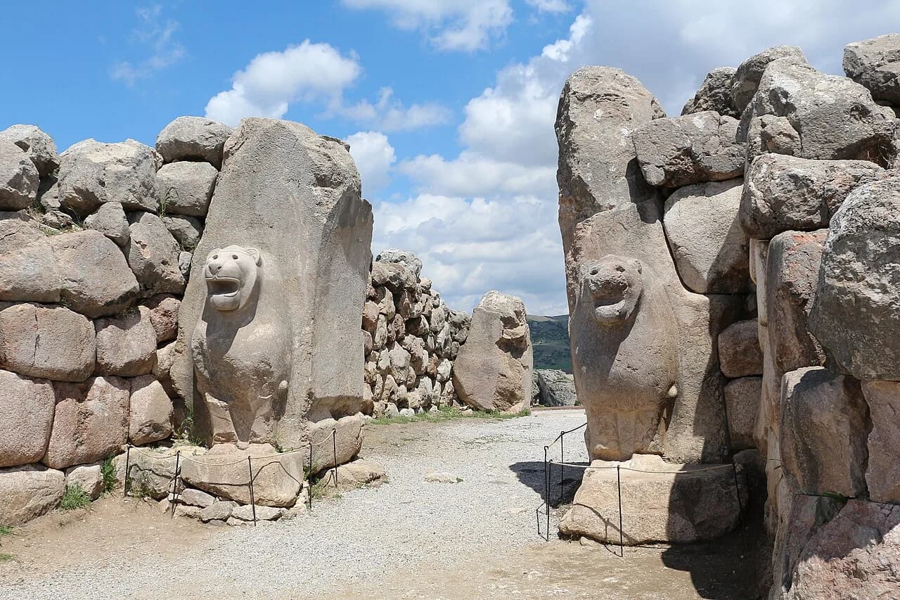
Two stone lions flank the southwest gate of the Hittite capital. The head of the left lion was lost at a time nobody knows.
The German Archaeological Institute has reconstructed it. A guidebook text says the head of the right lion served as the model. The lions are famous. Much about the wall behind them is still argued over.
The traditional view
UNESCO describes Hattusha as the former capital of the Hittite Empire. The German Archaeological Institute gives the years of its time as capital as about 1650 to 1180 BC.
UNESCO says a monumental wall of more than 8 kilometers surrounds the whole city. It says the upper-city fortification is a double wall with more than a hundred towers. It lists five gateways known so far. Two are in the west. The Lion's Gate is in the southwest, the King's Gate in the southeast and the Sphinx Gate in the south.
UNESCO adds that the fortifications, together with the Lions' Gate and the Royal Gate, "represent unique artistic achievements."
Trevor Bryce writes that Tudhaliya IV, who ruled from 1237 to 1209 BC, more than doubled the city by adding a new Upper City. He says Tudhaliya "also constructed massive new fortifications." Bryce describes a main wall on an earthen rampart 35 feet high with towers at 70-foot intervals.
A guidebook text on Turkish Archaeological News gives the gate towers as about 10 by 15 meters. It says the stones were "delivered in a roughly hewn state" and shaped to their exact form on site. It says the lions probably had a protective role, which researchers deduced from similar lion images in Hittite and Mesopotamian architecture.
The published numbers do not all agree. UNESCO gives the wall as more than 8 kilometers long. The German Archaeological Institute gives about seven. The guidebook text gives 6.6. Claudia Glatz gives a wall up to 8 meters high with towers every 10 to 12 meters.
Jürgen Seeher of the German Archaeological Institute writes that the Hittites built their city walls of unfired mud brick. He puts the towers 15 to 20 meters apart. Archaeologists reconstructed a 65-meter section at Hattusa.
What the Gate Cannot Tell Us
In Earthly Enigmas I do not discuss Hattusa or the Hittites. I do write about other Anatolian sites in Chapter 2, including Göbekli Tepe, Karahan Tepe and Derinkuyu.
Where the Accounts Split
The specialists disagree with each other on several points. Three of them stand out.
When was the wall built?
Bryce credits Tudhaliya IV. Glatz wrote in 2020 that "No firm date can be assigned to the construction of the fortification wall." She adds that it would seem logical for the wall to accompany the city's southward expansion. She also says most major construction happened "much earlier than previously assumed."
Seeher wrote in a 2006 abstract that the idea of an Upper City first emerging in the 13th century BC "must now be revised." The earliest settlement layers found so far in the western Upper City date to the 16th or 15th century BC. The abstract breaks off before its next point. I have not read the full paper.
The guidebook text says the outer fronts of the gate towers did not get their final smoothing. This has often been read as a late date, at the end of the 13th or start of the 12th century BC. The text also says building may have begun in the late 14th century and stopped. The German Wikipedia article on the gate credits that idea to Andreas Schachner, the current excavation director. I have not checked it in his own writing.
Zsolt Simon published a paper in 2011 titled "When were the fortifications of the Upper City of Hattuša built?" I have only seen an automated summary of it, so I do not quote it.
Glatz credits newly available radiocarbon dates, among other things, with changing the picture of the city. When was the wall built?
What were the wall and the gates for?
The wall looks like a fortification. Seeher's 2010 abstract says the towers helped observation and defense. It also says they belong to a "representative" building scheme (my translation from the German). The Hittites used it in the capital and in the provinces whether or not the terrain called for it.
He calls the regular towers a self-presentation of the ruler and his realm. The reconstruction of the 65-meter section showed that so many towers raised the effort of building the fortifications by 70 to 80 percent.
Glatz writes that the defensive value of Yerkapı, the great rampart at the south of the city, "has been questioned in the past." She finds it plausible that it served "primarily as a monumental stage for ritual performance." UNESCO describes the Sphinx Gate on top of that rampart, with an arched stone tunnel running underneath.
The excavation team agrees. Repola, Varriale, Marazzi, Morra and Schachner wrote in 2025 that Yerkapı "is hypothesised to have served ceremonial rather than defensive purposes." They report 249 painted hieroglyphs inside its tunnel.
The guidebook text on Yerkapı says "historians do not agree" and that "nothing can be said about the function of the passage." What was the wall for?
Why build on that scale when the state was struggling?
In 2005 Bryce wrote that "the Hittite world was living on the edge." He lists a defeat by Assyria, a rebellion near the frontier, a dynasty in dispute and a possible famine. He says the pharaoh Merneptah sent grain "to keep alive the land of Hatti."
Bryce then asks what prompted a "sudden and dramatic" surge of building in the kingdom's last decades. He writes that the rebuilding "remains a mystery."
Manning and colleagues found an unusually severe dry period in tree rings from around 1198 to 1196 BC. They write that it may have been a tipping point.
The dating question above bears on this one. Bryce places the building in the last decades. A different date for the wall changes what needs explaining. Why build on that scale?
The questions I can't put down
Some questions need more room than one article gives them. Two of them keep pulling me back.
How did a city this large feed itself? The German Archaeological Institute names this as a research question, because the region is in its words geographically rather unfavorable (my translation from the German). Diffey, Neef, Seeher and Bogaard report an underground silo complex that could feed 20,000 to 30,000 people a year. Glatz says the grain stored across Hattusa could have fed about 30,000 people for a year, about double the likely number of inhabitants. In Chapter 2 I write about Derinkuyu in Cappadocia, an underground city with a capacity of about 20,000 people according to Turkish government estimates. I ask there why it was built. I follow that question through Earthly Enigmas.
Where did the court go? Manning and colleagues report that the city was abandoned and emptied by the royal administration and only later burnt. They write that the reasons for the abandonment remain unclear. Bryce suggests that scribes carried the tablets away and writes that "the stuff had to go somewhere." In Chapter 11 I follow a chain of preservation that runs through the Stone Hills sites, Stonehenge and Carnac, oral tradition and the mystery schools. The Hittites are not part of it. You can read a free sample before you decide. The articles section has more subjects in the same format.
Sources
- UNESCO World Heritage Centre: Hattusha, the Hittite Capital
- German Archaeological Institute: Ḫattuša/Boğazköy, project page (German)
- Trevor Bryce, The Last Days of Hattusa (Archaeology Odyssey, 2005; Biblical Archaeology Society)
- Claudia Glatz, The Making of Empire in Bronze Age Anatolia (Cambridge University Press, 2020), chapter Placing Empire (quoted passages read from a text copy of the book; page numbers not recorded here)
- Jürgen Seeher, Chronology in Hattusa: New Approaches to an Old Problem (BYZAS 4, 2006) (author's abstract only)
- Jürgen Seeher, Wie viele Türme braucht eine Stadt? (Byzas 10, 2010) (author's abstract only, in German)
- Repola et al., Survey and Analysis of Hieroglyphic Inscriptions in the Postern of Yerkapı-Ḫattuša (Heritage 8(8):321, 2025)
- Manning et al., Severe multi-year drought coincident with Hittite collapse around 1198-1196 BC (Nature 614, 2023)
- Diffey, Neef, Seeher and Bogaard, The agroecology of an early state: new results from Hattusha (Antiquity 94, 2020) (author version)
- Turkish Archaeological News: Lion Gate in Hattusa (guidebook text; secondary; follows the German Wikipedia article closely)
- Turkish Archaeological News: Yerkapı in Hattusa (guidebook text; secondary)
- German Wikipedia: Löwentor (Ḫattuša) (secondary; read to locate sources and used only for the attribution to Schachner)