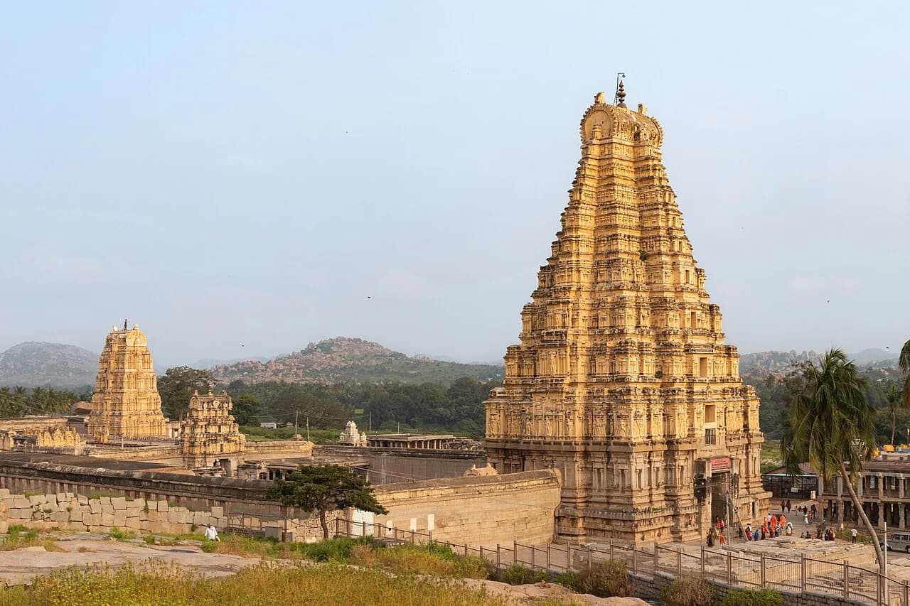
In 1565 an alliance of Deccan sultans took the capital of the Vijayanagara empire. UNESCO says the city was pillaged for six months and then abandoned.
Today one temple at the site still has worshippers and others stand empty. The sources do not agree on how much of the city was lost.
The traditional view
UNESCO describes Hampi as the last capital of the last great Hindu kingdom of Vijayanagar. It lists more than 1,600 surviving remains across 4,187 hectares. They include forts, temples, pillared halls and water structures. Most are built of local granite, burnt brick and lime mortar.
UNESCO places the capital between the 14th and 16th centuries. Robert Sewell wrote in 1900 that the city is generally supposed to have been founded in 1336. He cites an inscription of the first king dated 1340.
The Portuguese traveler Domingos Paes visited about 1520. In Sewell's translation he says that what he saw from a hill "seemed to me as large as Rome, and very beautiful to the sight."
Carla Sinopoli of the Maxwell Museum calls Vijayanagara a thriving city of more than a quarter million residents. She says its core covered 25 square kilometers.
UNESCO says the capital was "pillaged over a period of six months before being abandoned" after the defeat at Talikota in 1565. It also notes that building work at Hampi continued over a period of 200 years.
What the Evidence Does Not Settle
In Chapter 3 I do name Hire Benakal among the thousands of Indian megalithic sites. I describe that tradition as substantially underweighted by the standard narrative.
Frontline places the Hirebenakal megalithic cemetery some 50 kilometers from Hampi. That is the only link between the book and this place that I can show.
Where the Accounts Part
The sources agree that Hampi was a great capital and that it fell in 1565. They part ways on how much was lost, how large the city was and why it stood here. Three questions stand out.
How much of the city did 1565 take?
UNESCO says Talikota "led to a massive destruction of its physical fabric." Sewell wrote that the enemy reached the capital on the third day. From then on, he says, "for a space of five months Vijayanagar knew no rest."
He wrote that "never perhaps in the history of the world has such havoc been wrought, and wrought so suddenly, on so splendid a city." In the Basatin al-Salatin, as translated by Basu and quoted by Lycett and Morrison, the Muslim army "remained at Vijayanagar for about six months."
Mark Lycett and Kathleen Morrison reached a different picture in a 2013 paper. They describe "an historical tradition emphasizing the total destruction of the city." They find that the level and focus of destruction was "strikingly variable."
They report "no fire damage or defacement of images" inside the Ramachandra temple. The Vitthala temple took heavy damage along its central axis.
What came after is also disputed. Sinopoli writes that the city "was abruptly abandoned in 1565." The Penn Museum project page says "limited occupation continued thereafter." Lycett and Morrison write that the city and its hinterland "remained both habitable and inhabited." In Sewell's translation the Venetian Cesare Federici saw houses in 1567 that "stand still, but emptie."
UNESCO's criterion (iv) speaks of "living temples." Lycett and Morrison say only the Virupaksha complex "remained a living temple, probably more or less continuously." They write that the great Vaishnavite complexes stand empty.
How much of the capital did the sack take, and how much did the centuries after?
How big was the city?
Sinopoli puts the core at 25 square kilometers and the metropolitan region at least 450. The Penn Museum page puts the central city at some 20 square kilometers and says the fortifications encompass 650. UNESCO protects 4,187 hectares. I have not checked whether these figures measure the same thing.
The Wikipedia article on Hampi says the city is estimated to have been the second largest in the world by 1500, after Beijing. I have not checked that. Paes said only that it seemed as large as Rome.
Most of what made the city is gone. Fritz and Michell write that in the royal centre "only the stone basements and column footings are to be seen." Sewell wrote that the mud huts of "by far the greater portion of the inhabitants have disappeared." Lycett and Morrison say visitors are "mostly unaware of the vast size" of the unexcavated parts.
The stone is what remains. How large was the capital, and what did the timber and mud hold?
What drew a capital to this spot?
Sewell retells a tradition from the chronicler Nuniz. The founder reasoned that placing the river "between him and the ever-marauding Moslems" would make his people more secure.
Fritz and Michell describe a different draw. The site was already sacred, tied to the goddess Pampa and her consort Virupaksha. They write that "certain episodes from the Ramayana epic are believed to have taken place here." They say these associations give the granite ridges "a distinctive sacredness."
Candis Haak finds that Hemakuta Hill was "a site for pilgrimage since at least the 7th century." She says its Shaiva temples "date back to the 9th century." Fritz and Michell put the small early temples there in the tenth and eleventh centuries. Haak adds that the early history "has remained understudied."
What made this the place for a capital?
The questions I can't put down
Some questions need more room than one article gives them. Two of them keep pulling me back.
How were the pillars tuned? The Vitthala temple has a hall of columns that ring when struck. A 2008 study by Anish Kumar and colleagues describes itself as the first scientific investigation of them. It found "excellent correlation" between the measured notes and the frequencies calculated from each column's dimensions and ultrasonic velocity. Physics Today reports that every column tested was solid.
India Today says what remains unknown is how each column was tuned. I read that in a search excerpt only and I have not checked the paper. Robert Brubaker, quoted by Kuppa and Menon, calls the way Vijayanagara masons split their granite "something of a mystery." In the book I follow precision stonework at Puma Punku. You can read that article or follow the question through Earthly Enigmas.
What was this place before it was a capital? Haak and Fritz and Michell date the earliest temples to the ninth through eleventh centuries. A 2009 field report summary from Sinopoli and colleagues describes a nearby habitation site occupied from the Southern Neolithic. Frontline quotes Andrew Bauer dating Iron Age use of such hills to 1200 to 300 BCE. I have not read Bauer's own paper.
In Chapter 3 I name Hire Benakal as one of the megalithic sites I think the standard narrative underweights. You can read a free sample of the book before you decide. The articles section has more subjects in the same format.
Sources
- UNESCO World Heritage Centre: Group of Monuments at Hampi
- Robert Sewell, A Forgotten Empire (Vijayanagar) (1900), full text on the Internet Archive
- Lycett and Morrison, The "Fall" of Vijayanagara Reconsidered (JESHO 56, 2013)
- Fritz and Michell, Interpreting the Plan of a Medieval Hindu Capital, Vijayanagara (World Archaeology, 1987) (text shown in the page's figure panels only)
- Haak, A Digital Analysis of an Early Medieval Cultic and Ritual Change in Hampi (Histories, 2022)
- Penn Museum: Vijayanagara Research Project
- Maxwell Museum: Surveying the Imperial City of Vijayanagara (Sinopoli, 2020)
- Kuppa and Menon, Stories from Silent Stones (Heritage, 2018)
- Kumar and colleagues, musical pillars of the Vitthala temple (JASA, 2008), abstract on PubMed (paper paywalled, abstract only)
- Physics Today: Musical pillars made of solid granite
- Frontline: Megalithic wonder (2013)
- India Today: Mystery of Hampi's singing pillars (2026) (search excerpt only, secondary)
- Wikipedia: Hampi (used to locate sources and for the unchecked second-largest-city estimate)